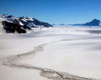
Photos of Shackleton Glacier and surrounding mountains. Most were taken from a Twin Otter during a reconnaissance flight to find prospective work areas and landing sites on the lower glacier. The massif in the first half of the photos (photos 3 - 22) is Mount Heekin. Others show the Swithinbank Moraine (a long medial moraine emanating from Matador Mountain), Cathedral Peaks and Waldron Spur east of the lower glacier, and Nilsen Peak. The heavily shaded mountains in the last few photos are Mt Speed and Mt Wasko, at the foot of the glacier on the west side. To locate peaks and spurs in the photos of the lower glacier, see the panoramas taken from Gemini Nunataks. There are also a few photos taken from Gemini Nunataks, a pair of low hills near the west edge of the glacier, where we landed and collected reconnaissance samples for exposure dating. Initial results from these samples show that the nunataks emerged from the thinning glacier about 6000 years ago.