Cosmogenic-nuclide measurements and stratigraphic info
Borehole SWRA-3
Key to drillhole logs
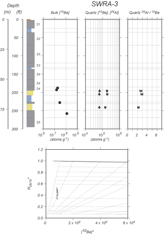
Be-10 and Al-26 in quartz
| | | Depth | | [Be-10] | | | | [Al-26] | | |
| Sample name | | (ft) | | (atoms/g) | | +/- | | (atoms/g) | | +/- |
| |
| SWRA-3-196 | | 196 | | 6.74E+04 | | 1.92E+03 | | 1.84E+05 | | 1.54E+04 |
| SWRA-3-205 | | 205 | | 6.45E+04 | | 1.91E+03 | | 1.90E+05 | | 1.25E+04 |
| SWRA-3-241 | | 241 | | 6.50E+04 | | 1.87E+03 | | 1.45E+05 | | 1.05E+04 |
Bulk Be-10 in sediment
| | Depth | | [Be-10] | | |
Sample name | | (ft) | | (atoms/g) | | +/- |
| |
| SWRA-3-188 | | 188 | | 1.85E+07 | | 4.75E+05 |
| SWRA-3-193 | | 193 | | 1.49E+07 | | 3.87E+05 |
| SWRA-3-228 | | 228 | | 2.86E+07 | | 7.24E+05 |
| SWRA-3-258 | | 258 | | 1.21E+08 | | 1.67E+06 |
Stratigraphy
Mass depths reflect the following density assumptions:
| What? | | Till | Glaciolacustrine | Sand | Loess | Silty sand | Gravelly sand |
| Density(g cm-3)
| | 2.25 | 2.06 | 2.13 | 2.18 | 2.06 | 2.49 |
These are averages derived from the density measurements here.
| Top depth | | Bottom depth | | Lithology | | Top depth | | Bottom depth | | Density | | Mass thickness | | Top mass depth | | Bottom mass depth |
| (ft) | | (ft) | | | | (m) | | (m) | | (g cm-3) | | of unit (g cm-2) | | (g cm-2) | | (g cm-2) |
| |
| 0 | | 2.5 | | LOESS | | 0.00 | | 0.76 | | 1.70 | | 130 | | 0 | | 130 |
| 2.5 | | 25 | | TILL | | 0.76 | | 7.62 | | 2.25 | | 1540 | | 130 | | 1669 |
| 25 | | 36 | | GL | | 7.62 | | 10.97 | | 2.06 | | 690 | | 1669 | | 2360 |
| 36 | | 71 | | TILL | | 10.97 | | 21.64 | | 2.25 | | 2395 | | 2360 | | 4755 |
| 71 | | 120 | | TILL | | 21.64 | | 36.58 | | 2.25 | | 3353 | | 4755 | | 8108 |
| 120 | | 132 | | TILL | | 36.58 | | 40.23 | | 2.25 | | 821 | | 8108 | | 8929 |
| 132 | | 136 | | GL | | 40.23 | | 41.45 | | 2.06 | | 251 | | 8929 | | 9180 |
| 136 | | 165 | | TILL | | 41.45 | | 50.29 | | 2.25 | | 1985 | | 9180 | | 11165 |
| 165 | | 185 | | TILL | | 50.29 | | 56.39 | | 2.25 | | 1369 | | 11165 | | 12534 |
| 185 | | 195 | | TILL | | 56.39 | | 59.44 | | 2.20 | | 671 | | 12534 | | 13204 |
| 195 | | 208 | | SAND | | 59.44 | | 63.40 | | 2.13 | | 844 | | 13204 | | 14048 |
| 208 | | 226 | | GL | | 63.40 | | 68.88 | | 2.06 | | 1129 | | 14048 | | 15178 |
| 226 | | 231 | | TILL | | 68.88 | | 70.41 | | 2.27 | | 346 | | 15178 | | 15524 |
| 231 | | 249 | | SLTSND | | 70.41 | | 75.90 | | 2.17 | | 1191 | | 15524 | | 16714 |
| 249 | | 269 | | TILL | | 75.90 | | 81.99 | | 2.20 | | 1341 | | 16714 | | 18055 |
| 269 | | 295 | | TILL | | 81.99 | | 89.92 | | 2.25 | | 1779 | | 18055 | | 19835 |