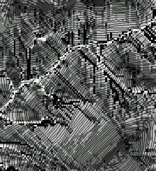
Figure 1. Soil distubance area and proximity to stream decrease as the tailhold anchor is shifted from ground-level (a) to a tail spar tree (b) to the far side of the riparian zone (c) and finally to the opposite ridge (d).
Finn Krogstad, Luke Rogers, and Peter Schiess
Presented at the International Mountain Logging and 10th Pacific Northwest Skyline Symposium, Corvallis Oregon, Mar 28 - Apr 1, 1999.
LoggerPC and ArcInfo are used to identify the spatial distribution of skyline yarding induced soil disturbance. Hydrologic functions in ArcGRID are used to estimate the likelihood that these exposed soils will deliver sediment to the stream network. Simulations in a steep basin suggest that significant yarding related sediment delivery can be avoided by setting cable anchors in or flying logs through a riparian corridor.
Keywords: Geographic Information Systems, erosion, sediment delivery, riparian, harvest planning.
Among the many goals of contemporary forest regulation, reducing riparian disturbance and reducing sediment delivery may be the two most often in conflict. While flying logs or even stringing cable through a riparian corridor may be discouraged as unacceptable disturbance of the riparian corridor, the alternative of building more roads (with more crossings of streams and steep slopes) is no more acceptable.
The increase in road density may be the most significant environmental consequence of this riparian protection, but restricting logging impacts to the riparian stands can eliminate options for improving deflection by anchoring tailholds within or beyond the riparian zone. It is unfortunate that skyline loggers loose flexibility in setting tailholds so close to the stream where a disturbed soil can deliver sediment to the stream most efficiently.
The input of fine sediment on the survival of incubating and juvenile salmonids has been a subject of study for most of the century (Everest, et al. 1987). The significance of forest roads and yarding operations on fine sediment delivery is also well studied. With advances in computing power and geographic information systems (GIS) we can now consider the spatial distribution of soil disturbance under alternate yarding configurations and the hydrologic processes that determine whether this soil is carried down into the stream network.
GIS also provides the opportunity to evaluate alternate impacts on riparian stands and the stream functions they support. Among these functions are temperature control, detrital leaves and insects, large woody debris (LWD) and the hydraulic structure it supports. Cable operations can be detrimental to riparian stands and thus stream functions through cable anchoring, cable whipping, and swinging of logs.
If we are to justify the damage resulting from extending cable settings through these riparian stands, we must be able to identify equally significant environmental impacts that longer reaching cable systems can avoid. The road impacts on hydrology, sediment, and habitat fragmentation can be identified and estimated. This paper focuses on the soil disturbance and sediment delivery resulting from inadequate deflection that can be produced when attempting to log without significant impact to the riparian stand.
This study was prompted by and set in a landscape that is particularly suited for long-reach skyline operations. Prospector Creek, a tributary to the Washougal River in south central Washington state, is typical of the steep (average 70 percent slopes) valleys in the upper part of the Washougal basin. The planned road network is concentrated towards the ridges, minimizing concerns about road impact contributions to peakflow, fine sediments, and landsliding. The major watershed issues in these cases are harvest related impacts on stream peakflow, fine sediment delivery, and riparian leave trees. The low productivity and difficult access restricted economically viable option to clearcutting, which in turn eliminated the potential for reducing rain-on-snow peakflow impacts through partial harvesting. The watershed impacts from alternate design options thus reduced to a tradeoff between harvest related erosion and riparian impacts.
The long steep uniform hillslopes common in the Prospector Creed area drastically limited the deflection potential even beyond 2000' (see Figure 1a). The use of tail trees for elevating the tailhold anchors (Figure 1b) became an integral part of the landscape harvest design for this planning area (Schiess 1998). Further deflection could be gained by anchoring the tailhold on the far side of the riparian area (Figure 1c) with deflection maximized using a tailhold on the opposite ridge. However, in several instances ridges remained inaccessible because of the topography and, steep and sensitive slopes
Determining soil disturbance from logging operations is a multi-step process (Figure 2) utilizing ArcInfo and Oregon State University's LoggerPC (1997). Getting information into LoggerPC from ArcInfo is accomplished using a program written in ArcInfo's internal programming language, AML. The first step is to locate landings in ArcInfo. Users are prompted for landing locations, maximum external yarding distance and the number of cable roads. ArcInfo then generates the cable roads and extracts the profile data for input into LoggerPC. Profile data can be generated at any interval, however, choosing an interval equal to the cell size of the DEM seems to work the best.
Importing the profiles into LoggerPC is done using the PLANS X,Y,Z import format. In LoggerPC, yarders, cable sizes and carriages should be selected to minimize soil disturbance. In attempting to minimize soil disturbance exceptionally long external yarding distances become a necessity, often locating tailholds across entire valleys. Since the skyline may be as much as three hundred feet off the ground near the bottom of the valley, long drop-lines are necessary. Operationally this implies only a few options, a four-drum yarder with a mechanical drop-line and a three-drum yarder with a motorized carriage. These were the two systems we used in our analysis.
For the analysis discussed below a Thunderbird TY 90 with a 90 foot tower and an Eagle IV motorized drop-line carriage were used. For the cable analysis we assumed a choker length of 15 feet, a 14 inch log diameter and a 32 foot log length. Our target payload was 6000 pounds with a minimum acceptable payload of 4000 pounds. In many instances where we had poor deflection LoggerPC would not allow payloads using the standing skyline configuration. In these instances we used either a running or live skyline to increase our payloads.
Figure 1. Soil distubance area and proximity to stream decrease as the tailhold anchor is shifted from ground-level (a) to a tail spar tree (b) to the far side of the riparian zone (c) and finally to the opposite ridge (d).
After the analysis is completed in LoggerPC the payload suspension information is brought back into ArcInfo and merged with the existing landing profiles. These profiles are then converted into grids for sediment analysis.
The process of creating landing and profile information for LoggerPC and for bringing suspension information back into ArcInfo is simple and quick. LoggerPC is an excellent tool for analyzing individual profiles or even an entire setting. For the purpose of mapping sedimentation, we used LoggerPC since it gives suspension information in an exportable format. However, when planning on the landscape level, LoggerPC would be too time intensive. At the landscape planning level a program like the Forest Service's Preliminary Logging ANalysis System (PLANS, Twito 1988) would provide similar results with less time commitment. As the program is written, extracting suspension information would require a C program patch. Modifying PLANS and our existing AML's to work to map sediment is one of our goals.
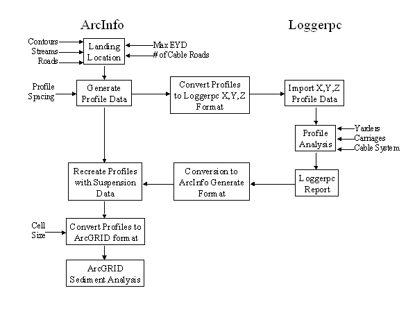
Figure 2. The ArcInfo/LoggerPC interface process.
Sediment delivery is a function of the soils, slope, rainfall, and disturbance for a given section of soil, the amount of water flowing across the site from upslope, and the filtering effect of soils and vegetation as this sediment travels downslope. Past efforts at sediment delivery have focussed on areas with uniform features such as agricultural fields (Wischmeier and Smith 1965). Sediment from forest roads can also be modeled (Dube, et al. 1998) since road construction tends to produce uniform properties. A similar approach has been applied to harvests (Cline, et al. 1981), to estimate sediment delivery from alternate harvest methods.
In comparing sediment delivery from slightly different cable layouts however, we need to look at each part of the hillslope individually, since a small shift in tailhold location or payload can determine whether there will be soil disturbance. The location of each patch of disturbed soil will determine whether water from upslope is running across that soil, the path that water will take downslope, and whether the sediment will be filtered out along the way. Sediment erosion is a function of several factors:
Management - Disturbance of the vegetation and litter cover exposes the soil to erosion. The cable analysis above identifies the areas of soil disturbance.
Soil - High silt and clay content commonly inhibit infiltration, promoting runoff and erosion. Future analysis will allow for different soil types.
Precipitation - Higher storm intensity increases the likelihood and volume of overland flow. Future analysis will allow for different storm intensities.
Contributing Area - The likelihood and volume of overland flow increases with the area upslope. The upslope contributing area above each DEM cell is a standard product of many GIS.
Slope - The steeper the slope, the greater the hydraulic gradient, the thinner the saturated layer (for a given flow volume), and the less likely that water will be flowing across the surface. Hillslope or flow gradient is also a standard GIS product.
Sediment mobilized by precipitation is not necessarily delivered to the streams. Filtering occurs when water is forced to flow through filtering material such as an organic soil layer or even mineral soil. If post harvest downslope flow becomes subsurface flow or even flows through the litter layer, the surface area is sufficient to remove much of the sediment. The occurrence of overland flow is highly variable across the slope and throughout the storm. Whether downslope flow remains as surface flow or disappears into the soil is largely a function of soil depth and upslope contributing area. The more upslope contributing area, the more likely saturated thickness will exceed soil thickness and flow across the surface.

Alternately, we can estimate the likelihood that the saturated thickness is less than a given soil thickness, that water is not flowing across the surface and that filtering is occuring. This filtering factor is easily coded into ArcGRID as follows.
F = flow_grad / (float(flowacc) + 1)
The sediment that is not filtered by one section of slope can be filtered by the next, and so on, so the delivery fraction is a negative exponential function of all the individual filtering factors that a packet of sediment laden water will flow over on its way to the stream. This exponential reduction in sediment delivery is similar to Ketcheson and Megahan's (1996) exponential distribution of sediment travel distances from road culverts, and their decay constant of 46.43 feet can be put into the sediment delivery equation
D = exp(- flowlength(flowdir, F))
Sediment delivery to the stream network is thus the sediment produced by each cell times the fraction not removed by the soil and vegetation of each cell downslope.
|
|
|
|||
|
|
Figure 3. Sediment Filtering factor F (the ratio of the slope to the upslope contributing area) declines downslope towards the stream network. |
|
Figure 4. The fraction of sediment reaching the stream declines with distance from streams and saturated areas. |
|
We can now create some alternate harvest settings and map out the areas of soil disturbance and identify which of these deliver non-negligible amounts of sediment to the stream. We will focus on profiles c and d in Figure 1, which demonstrate the methodology and process.
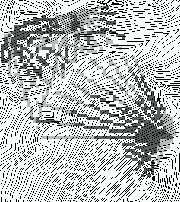
The conventional setting with external distance < 2000 feet is shown in Figure 5. Setting tailholds beyond the riparian zone (corresponding to the profile in Figure 1c) provides deflection across the critical lower slopes which are most likely to deliver to the streams. Nonetheless, it's frequent soil disturbances occasionally does hit a patch of soil that is well connected to the stream network, and sediment delivery occurs.
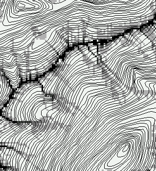
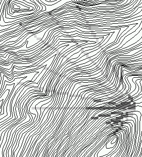
The long-reach alternative is displayed in Figure 6 (profiled in Figure 1d), and just as expected, it produces very little soil disturbance, and that disturbance is concentrated on the upper slopes that have little chance of delivering sediment to the stream network.
In comparing harvest options with different combinations of riparian drainage and sediment delivery, it would be desirable to have a function for estimating the habitat loss as a function of sediment and wood.
habitat=f(trees,sediment)
|
|
|
||
|
|
Figure 5. A setting design with anchors beyond the riparian zone (figure 1c) disturbs soil particularly in the upper slopes (upper image), but the highest sediment delivery (lower image) comes not from the most disturbed soils, but rather from the wetter slopes. |
 sediment fraction delivered to stream |
Figure 6. A long-reach setting (figure 1d) creates much less soil disturbance, which is concentrated on the upper slopes (upper image), producing almost no sediment that is delivered to the stream (lower image). |
Lacking such a function, this paper focusses on delivery processes rather than attempting to assign a sediment volume or mass per unit area of hillslope. One might be tempted to estimate the width of soil disturbance for each cable line to get an area of disturbance, then multiply by some empirical erosion rate for that soil type and slope. Care should be exercised when approaching this problem however, since it is easy to see that runoff works very differently if the disturbance is oriented downslope rather on a side slope. In the former, runoff would be accumulating as it moves down the disturbed track, but it would quickly flow back into undisturbed soil in the latter case. In future versions, the issue of disturbance direction can and will be addressed in the upslope area/downslope flowpath approach.
Another pending improvement is to switch from LoggerPC which is better for individual profiles, to PLANS which is better for entire settings. In switching, we intend to automate this process so that alternate plans for an entire landscape level planning area can be compared.
Cline, R., Cole, G., Megahan, W., Patten, R., Potyondy, J. 1981. Guide for Predicting Sediment Yields from Forested Watersheds. USDA Forest Service Northern Region Intermountain Region. 48 p.
Dube, K.V. and Wold., W.L. 1998. SEDMOD: A GIS-based road erosion and delivery model, Eos, 79(45): F352
Everest, F.H., Beschta, R.L., Scrivener, J.C., Koski, K.V., Sedell, J.R., Cederholm, C.J. 1987. Fine sediment and salmonid production: a paradox. In Salo, E.O., Cundy, T.W. Eds. Streamside Management: Forest and Fishery Interactions. U. Washington. Coll. of For. Res. p. 98-142.
Ketcheson, G.L. and W.F. Megahan. 1996. Sediment Production and Downslope Sediment Transport from Forest Roads in Granitic Watersheds. U.S.D.A. Forest Service. Intermountain Research Station. Research Paper INT-486. 11 p.
LoggerPC 3.2. 1997. LoggerPC 3.2 Users Manual. Oregon St. U. Dept of For. Eng. Corvallis. Oregon. 112 p.
Schiess, P. 1998. A Management Plan for the Washougal Landscape. University of Washington. College of Forest Resources. 131 p.
Twito, R.H., McGaughey, R.J., Reutebuch, S.E. 1988. The SKYTOWER and SKYMOBILE Programs for Locating and Designing Skyline Harvest Units. USDA Forest Service, General Technical Report, PNW GRT-215. 35 p.
Wischmeier, W.H. and Smith, D.D. 1965. Predicting rainfall-erosion losses from cropland east of the Rocky Mountains. U.S.D.A. Agricultural Handbood No. 282.
The reported project is supported through funds provided by the Washington State Department of Natural Resources. Mentioning of brand names does not imply any endorsement by the authors or the funding agency.
THE AUTHORS
Finn Krogstad and Luke Rogers are graduate students in Forest Engineering at the College of Forest Resource, University of Washington, Seattle, WA 98195. Peter Schiess is Professor of Forest Engineering in the College of Forest Resource, University of Washington, Seattle, WA 98195.