After about a 25-year hiatus in work by UW faculty and students on local bedrock geology, in the 1950s W.R. “Ted” Danner made an exhaustive study of rock units in northwestern Washington. He focused primarily on those containing limestone for his PhD thesis, completed in 1957. He probably visited even the most remote outcrops and quarries. In the San Juan Islands, limestone was economically important in the early 20th century: consider the quarries and kilns at Roche Harbor and Limestone Point. Perhaps Danner's most important discovery was the remarkable similarity of fossil fusulinids – marine foraminifera that lived in the Permian Period about 270 to 250 million years ago – to the same protozoans found in rocks of the same age in Japan. He might have been the first geologist to speculate on the “exotic” nature of this fauna, and raised the surprising possibility that the Permian rocks in the San Juans and Northwest Cascades had travelled thousands of kilometers from where they were originally deposited, bringing these fossils with them. Danner later became a professor at the University of British Columbia. In the 1960s, UW professor Joseph Vance began geologic mapping and studies of the bedrock on Orcas and San Juan islands. He supervised graduate student research and brought field courses there to learn geologic mapping.
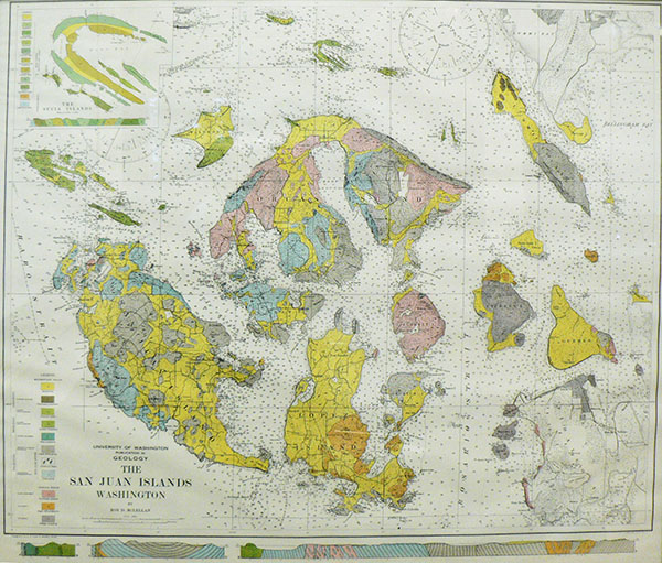
I arrived at UW as an assistant professor after a short career as an exploration geologist in the Alaska Division of Shell Oil Company, in August 1974. Before Autumn Quarter began, I visited UW Professor John Whetten’s field class for majors and non-majors at Camp Nor’wester, then on the Sperry Peninsula on Lopez Island. I was struck by the similarity of some of the rocks on Lopez to rocks I had studied in California and Alaska. In 1975 Whetten and Vance each published papers, based on their own geologic mapping, in a Washington Department of Ecology Water Supply Bulletin. They compiled a new color map of the islands, the first since McLellan’s. The names, ages, and colors have changed from the 1927 to the 1975 map, but the overall disposition of rock units is similar: a credit to McLellan’s perceptive mapping.