Physical Characteristics of Argyle Creek
The San Juan Islands
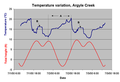
experience a twice daily tidal cycle, where coastal areas each day experience
water depth changes as two tidal highs and two tidal lows. Each pair
of highs or lows is not necessarily equal in height, but the rise and fall
follows a consistent pattern. A typical tidal pattern in the San
Juan Islands can be traced along the red line in the graph below, starting
at the end of section A: the tide first reaches a "high" high tide (referred
to as a high-high), followed by a high-low, a low-high, and a low-low.
This tidal pattern results in Argyle creek draining and filling twice a
day, as partly reflected by a somewhat complicated pattern of temperature
change within the creek. Section A of the graph shows the longest
drain time that Argyle experiences, about 14 hours in duration. The
water drain corresponds to a large temperature increase of about 9 degrees
C. The temperature then rapidly decreases as cold ocean water (about 10
degrees C) flows back into the lagoon. The temperature plateaus,
labeled B, indicate the short drain and fill time between the high-high
and the high-low.
As Argyle Creek drains, it never runs dry. The
lowest part of the creek is about 5 feet above sea level (5 ft. above the
average daily low-lows for the year 2000), and at low tides water depths
in Argyle Creek measure about 12-20 cm along the thalweg.
The creek bed at Argyle is composed of glacially derived sediments, ranging
in size from clay to boulders. The dominant sediments are smaller
smooth pebbles and larger rough cobbles, along with dead clam and barnacle
shells, and live oyster and barnacle shells.