
Oyster Growth
|
Oyster Growth |
Spatial Variation in Secondary Productivity |
|
We use the Pacific oyster, Crassostrea gigas, as a sort of “ecological sponge” to tell us about the characteristics of the estuarine environment. We are especially interested in the energetic support of food webs, and how productivity varies across multiple spatial scales. Since 2000, we have been tracking the spatial pattern of oyster growth in Willapa Bay by transplanting small oysters to multiple locations, leaving them for a few months, and recording their growth and stable isotope ratios. |
|

|

This map shows 9 sites where oysters were outplanted in 2001. Willapa Bay has two arms - a short eastern arm where Range Point (RP) is located (South Bend is at the next bend in the river), and a longer southern arm with little freshwater input. |
The tiny 2-week old oysters above grow into the oysters below in about a month. |
|

|
|
Because oysters are filter feeders, growth rates tell us about the food availability in the water. |
|
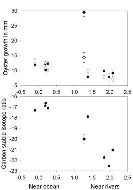 The top graph shows that growth rates vary dramatically throughout the bay. Dark points show how much growth occurred from May-July 2001 (in terms of linear shell extension), and light points show growth from July-September 2001. Sites are arranged along a water temperature gradient - warmer sites receive less cold ocean water and are farther into the bay. In general, growth declines with distance from the ocean, so that oysters in the southern arm grow half as fast as near the ocean. Range Point oysters are a dramatic exception, indicated by the diamond points of fast growth but moderate water temperatures. Stable isotope analysis capitalizes on the fact that “you are what you eat.” Different primary producers (phytoplankton, eelgrass, algae, benthic microalgae, terrestrial or marsh plants) have different characteristic signatures of naturally-occurring isotopes of common elements, such as carbon and nitrogen. When we look at the stable isotope signatures of oysters, we can tell, in a general sense, which ones have been eating more “stuff” that comes from the ocean vs. comes in through rivers from the land. We’ve focused on stable carbon isotopes, because these vary dramatically between oceanic phytoplankton (d13C = -18 to -22) and terrestrial plant material constituting watershed inputs (d13C = -23 to -26). The bottom graph shows that oysters are eating food made of different carbon isotopes throughout the bay. In Willapa Bay (and Grays Harbor in 2002), the results from stable isotope analysis map very well onto how close oysters are to the ocean: Oysters close to the ocean have stable-carbon isotope ratios similar to marine phytoplankton, whereas oysters far from the ocean have ratios that are closer to terrestrial plants (they may be eating detritus from rivers and marshes or, more likely, phytoplankton that grow in the rivers). We don’t know yet how much eelgrass detritus oysters are eating, but eelgrass detritus is one possible explanation for stable-carbon isotope ratios outside the range of either marine or terrestrial food sources. Interestingly, even though oysters near the Naselle River and Willapa/North Rivers eat similar food (their stable isotope ratios are similar), they have very different growth. Essentially, the river-based food from the large Willapa/North Rivers fuels very productive oysters, but the same food from the small Naselle River cannot support fast growth of oysters in the south-east part of Willapa Bay. In Grays Harbor, the gradient from the ocean to the Elk River seems most like the North/Willapa River arm of Willapa Bay (better growth further up the river). In summary, oysters grow best close to estuary mouths in coastal estuaries, fueled by marine inputs, and also near large river mouths, fueled by terrestrial inputs. |
|
 |
|
|
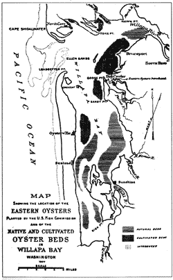
The large-scale patterns of secondary productivity in Willapa Bay mirror local ecological knowledge about the best places to grow oysters. This map was drawn in 1894. It shows that native oysters (Ostreola conchaphila) recruited quite a distance away from the ocean, but oysters were intentionally moved closer to the ocean before harvest. This pattern still holds true, because most fattening beds, where oysters reach market size, are located at Stackpole (ST), Bay Center (BC), Stony Point (SP), and Toke Point (TP). We have tested several other factors that affect oyster growth at smaller scales: 1) oysters grow slower when they spend more time out of the water, and 2) oysters grow slower when grown on the bottom relative to off-bottom, if the tidal elevation is otherwise equal. We still do not know how much local depletion of food occurs by oysters – the year we are testing more explicitly for food limitation by neighbors (intraspecific competition). |
|
|
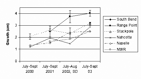
During the past 4 years that we have tracked oyster growth in Willapa Bay, growth rates have improved everywhere. (There have also been differences in initial size, growth interval, and specific locations.) Indeed, in 2003, there was no longer any spatial variation in growth from Stackpole to Nahcotta (and only slightly lower growth in the south end of the bay near the mouth of the Naselle river and the National Wildlife Refuge headquarters). Why have conditions improved for oysters? We do not know, although changes in weather and nearshore oceanic properties may play a role. High growth at Nahcotta in 2003 is puzzling, because the water samples we collected from the different locations clearly show lower chlorophyll in the south part of the bay. Chlorophyll is the photosynthetic pigment in phytoplankton, which are a major food source for oysters. (LISN and LISS are southern sites.) |
|
 |
|
UW Biology | University of Washington |
Created by Lee McCoy, Updated by Jerome Tichenor, March 19, 2013 |