QRC members lead and participate in a wide range of disciplinary and interdisciplinary research projects from the study of past earth climates and glaciations to shifts in the geographic distributions and evolution of vegetation and faunal communities, to the evolution and dispersals of the genus Homo and the increasing scales of human modification of earth environments through the Holocene. QRC provides a venue for meeting and collaborating with scholars across Quaternary disciplines. We are also fortunate to be able to provide seed funding and small grants for member research projects. We are especially happy to support grad student and junior scholar research activities, much of which leads to larger, external funding from agencies like the National Science Foundation. Since the program’s launch in 2014, we have funded over 100 research projects.
Geoarchaeological Research of sediment samples from Angkor, Cambodia
Abstract: The largest premodern government in mainland Southeast Asia, the Angkorian empire, centered mostly in Cambodia, ruled from the ninth to the fifteenth centuries AD. During this time, numerous massive temple monuments, including Angkor Wat, were constructed. Previous research has shown how the central area of Angkor Wat was inhabited by extensive low density urban settlements (Carter et al. 2018), with distinctive cycles of decline and reorganization (Carter et al. 2019). Previous work on hydroclimate reconstruction from tropical southern Vietnamese tree rings (Buckley et al. 2010) has indicated that Angkor experienced drought during the time of the transition from the Medieval Climate Anomaly (MCA) into the Little Ice Age (LIA). This drought appears to have led to the failure of Angkor as a viable city. However, little is known about how the remote areas of the empire were involved in these processes of expansion and decline, and how these drought events affected their involvement in the empire. We ask what impact did incorporation into the Angkor empire have on these settlements at the edge of the empire, and how did climate change affect their integration?
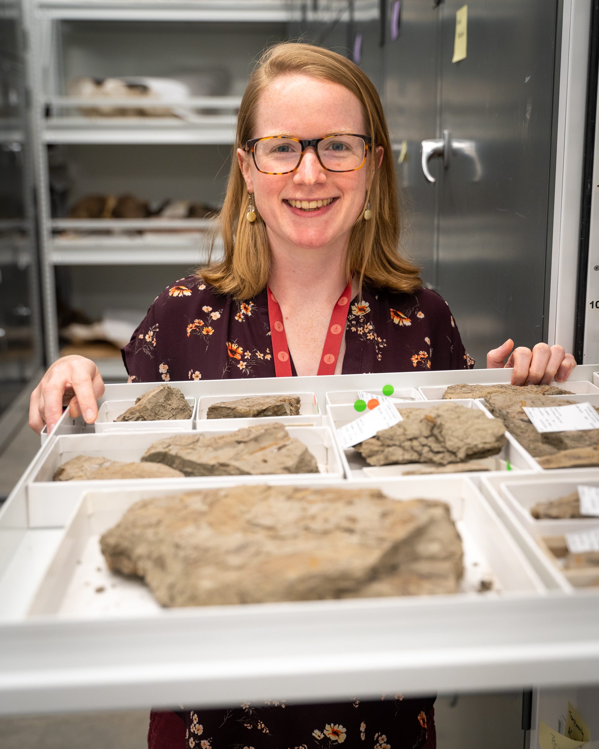
Estella Leopold Collection and Lab management Project
Abstract: Esteemed Emerita Professor Dr. Estella Leopold built a world-class research collection and laboratory during her tenure at the University of Washington (UW). Dr. Leopold is a pioneering paleobotanist, conservationist, and woman in science; she is the second ever Director of the QRC, member of the National Academy of Sciences, and esteemed Professor Emerita of the Biology Department at UW. Her research on Quaternary and Cenozoic climate around the world and her conservation efforts–leading to the founding of the Florissant Fossil Beds National Monument, co-founding the Aldo Leopold Foundation to keep the land ethic legacy of her father alive and thriving, among many other accomplishments–are a crowning contribution to UW’s reputation.
We have been entrusted with the responsibility to properly move and catalog Dr. Leopold’s collections of fossil specimens, equipment, and reference materials. Over the summer of 2023, and with the support of the QRC, we plan to inventory, coordinate, and move the various elements of the Leopold Lab in Johnson Hall as well as collections stored in Hitchcock Hall. Our project aims to ensure that these resources are still accessible to the Quaternary science research community and that Dr. Leopold’s legacy is preserved. As former director of the QRC, her significance within the QRC community warrants the investment to preserve her legacy. This project will also enhance the UW Burke Museum paleobotany collection in terms of specimens, reference materials, and laboratory equipment. We aim to serve as a hub of palynology research at the UW, of particular interest to many members of the QRC. We also intend to work with the QRC, Biology, Earth and Space Sciences, and Burke Museum to determine the best new home for the reference materials and equipment in the Leopold Lab. This project presents an opportunity to safeguard Dr. Leopold’s legacy and to improve the palynological and paleobotanical resources at UW; we look forward to sharing these resources with the QRC community in research and outreach endeavors in the future.
Investigating Strike-Slip Faulting in the Hyper Arid Core of the Atacama Desert, Northern Chile
Abstract: The Salar Grande Fault (SGF) is a dextral-oblique fault system within the northern segment of the Atacama Fault Zone (AFZ), in Northern Chile. The study area is immersed in hyper-arid desert conditions (< 2 mm/year rainfall), with excellent surface preservation markers indicating strike-slip fault motion. The region sits within one of the most active subduction zones in the world, where future magnitude 9 earthquakes from the megathrust and tsunami waves up to 30 m are expected to impact the coastal towns. Reconstructing the landscape evolution of the SGF is essential to understand the role of crustal faults in subduction zone settings and the interaction between deeper tectonics and surface processes.
This QRC fund supports two methods to provide Quaternary and Cenozoic evolution data to the study area.
Optical Luminiscence Dating (OSL) techniques working with the USGS Luminescence Laboratory Facilities: We took several samples from fluvial deposits, alluvial fans and fault scarps, to date humid periods and potential paleoseismic activity in the study area. These ages contribute to build a better paleoclimatic record of the study area.
Pilot study of thermochronology in apatites with the CU-Trail Facilities: we took 8 samples from a transect up to the top of the mountains of the study area. Our goal is to reveal the exhumation history of the mountain range and the role of the SGF in the uplift of the region.
This is an essential part of my research and Ph.D. dissertation at UW and these project are both collaborations between the ESS Department and other institutions like CU Boulder and the USGS. We hope to present these results in conferences and publish at least one peer-reviewed publication from the data.
Examining the Chronology of the Foothills Erratics Train, Alberta, with in-situ Optical Surface Exposure Dating
Abstract: Optically stimulated luminescence (OSL) depth profiles from quartz can be used to extrapolate rock surface exposure ages with an understanding of a sample’s light attenuation and OSL bleaching behaviors. However, the current measuring procedure for producing depth profiles, which involves measuring the luminescence of millimeter slices from surface core samples, offers low resolution data, limiting age and parameter extrapolative accuracy for the dating technique. Further, OSL anomalies from non-quartz mineralogical variations in the measured samples can cause depth profile data scatter in dating quartz rich rocks, further limiting age extrapolative accuracy.
Obtaining OSL depth profiles with the use of sub-millimeter OSL laser scanning measuring protocols on transverse core slices, rather than obtaining OSL from millimeter slice segments, has potential for improving the data resolution of OSL depth profiles. Further, with this spatially resolved OSL data, one can identify and eliminate OSL non-referential to light exposed quartz with the use of scanning electron microscopy energy dispersive x-ray spectroscopy (SEM-EDS) measures. This filtering process may reduce the amount of data scatter present in depth profile datasets of heterogeneous rock mediums, which may offer improvements in parameter extrapolative accuracy for quartz OSL dating.
Thus, the QRC sponsored project aims to trial using these enhanced luminescence measuring protocols to surface date three erratics from the Foothills Erratics Train in Alberta, Canada. The erratics are believed to have been deposited along the margins of the Cordilleran and Laurentide Ice Sheets during their latest glacial retreat. Ongoing controversies concerning the surface exposure dates of these erratics using cosmogenic nuclides have complicated interpretations of glacial histories and interactions between the Cordilleran and Laurentide ice sheets during the upper Pleistocene, with particular questions of when an ice-free corridor between the Laurentide and Cordilleran ice sheets opened up, which would have allowed for the migration of humans into North America. Optically stimulated luminescence is a chronometer more sensitive to millennial timescales than what cosmogenic nuclide dating can provide, and may be able to document retreat direction chronologies via surface exposure dating applications using the proposed novel OSL measuring techniques.
Using Stable Isotopes of n-Alkanes to Track the Uplift of the Cascade Mountains of Washington, USA
Abstract: The Cascade Mountains are one of the dominant geographic features of the Pacific Northwest. The Cascades produce a large rainshadow effect, which is expressed as a regional dichotomy in climate and vegetation. This dichotomy has been a major controlling factor on the natural history and biogeography of the area, which in turn has strongly influenced local cultures and economies, yet the timing of the Cascade orogeny is poorly constrained. This project endeavors to better constrain the uplift chronology of the Cascade Range of Washington State by determining the onset of its orographic rainshadow, as recorded in the d2H and d13C values of leaf wax n-alkanes in sedimentary rocks both east and west of the range’s crest. These isotopic values are controlled, ultimately, by the local climate: leaf-wax n-alkane d2H has been shown to correlate strongly with local atmospheric d2H across the Cascades (Sisley et al. 2023). These biomarkers are persistent in the rock record and can be used to elucidate past climate conditions and, by extension, the presence or absence of the Cascade rainshadow through time. Our results will provide important context for researchers studying local tectonic and evolutionary history.
Constraining Astoria Canyon’s distal depocenter: Discovering the balance of gradual and episodic accumulation along WA’s outer slope
Abstract: Marine sedimentary deposits along the Cascadia margin have long been a source for insight into historical events and processes including: seismic recurrence; floods, storms and other oceanographic processes; and geochemical exchanges in the Pacific Northwest. This history is accessed through sediment core collection and analysis (210Pb geochronology, grain size analysis, imaging, tracers). Prior studies have implemented these methods over segments of the Washington Margin, but gaps in core coverage preclude a comprehensive view of the margin. Recent core data collected from upper Astoria Canyon have proven that modern hydrodynamics are capable of flushing sediment to depths far greater than initially anticipated, but this study was not able to constrain the depth of the canyon depocenter. These dual factors have spurred new interest in a coring survey over this coverage gap with two goals:
core sites within Astoria Canyon will define the down-canyon extent of modern sediment deposition, and
cores within and surrounding the canyon allow for the creation of an accurately interpolated map of sediment accumulation throughout northern Cascadia.
The proposed field effort will collect a series of box and kasten cores from Astoria Canyon and the surrounding slope, and analyze them for 210Pb geochronology, grain size, and stratigraphic analysis through computed tomography. The results from this proposed effort will contribute a more refined knowledge of both local canyon sediment depositional processes, and margin-wide accumulation.
Abstract: Astoria Canyon was the submarine extension of the Columbia River discharge during low-stand conditions in the late Pleistocene and early Holocene. However, under current high-stand conditions, the connection between Astoria Canyon and the Columbia River is less direct, with the mouth of the Columbia separated from the canyon head by about 20 km. Although the Columbia River remains the likely source of any modern sediment-gravity flows down Astoria canyon, the processes of transport, deposition, and remobilization on the continental shelf have imparted signatures on any Columbia River sediment reaching Astoria Canyon. The goal of this work is to characterize deposits of Columbia-derived sediment along a transect between the modern river mouth and the head of Astoria Canyon. The depositional history (via 210Pb geochronology) and sediment characteristics (e.g., grain size, physical structure, porosity) of shelf sediments will be compared with active sedimentation processes in the head of Astoria. By comparing the century-scale history of deposits on the shelf with modern sedimentation in the canyon head, we will improve our understanding about the the degree of coupling between modern sediment discharge from the Columbia River and delivery to Astoria Canyon.
Sediment Supply to Astoria Canyon: Canyon Head Sedimentary Processes
Abstract: During low stands in sea level, Astoria Canyon was the submarine extension of the Columbia River dispersal system and many of the submarine deposits associated with it (e.g., Astoria Fan) are thought to have been sourced from the Columbia River. However, in modern conditions, sources of sediment to Astoria Canyon are less well understood, and could include erosion of local canyon walls, wave-supported sediment gravity flows, or bottom-boundary layer advection of sediments. Hydro- and sediment dynamics of the Astoria Canyon head will be examined using an instrumented benthic tripod as part of a USGS-funded project.
With this additional work supported by QRC we will expand the scope of that project to examine modern sedimentation within the canyon head using a combination of surface grab and box core sampling, and deployment of sediment traps in conjunction with the instrumented tripod. The proposed instrument deployment will encompass a summer field season, and thus we can evaluate dynamics and conditions by adding ship-based sampling when the tripod is deployed and retrieved (proposed for June and September of 2019, dependent on collaborative UW-USGS ship-time scheduling). The canyon head has complex morphology, and thus differing dynamics and sediment-accumulation patterns, and capturing a range of variability is essential not only for evaluating the erodibility and geotechnical strength of the sediment, but also for targeting future coring efforts. The characteristics of these modern sediments (e.g., grain size) will be compared with sediment cores collected on the shelf (see linked QRC project, PI Fricke). This will help determine whether sediment actively transported or deposited in the head of Astoria Canyon is derived from local sources, or shelf sediments, and if the latter, the degree of reworking (i.e., winnowing) of those source deposits. Dynamical measurements collected with the USGS-funded instrumented tripod will constrain the type and intensity of processes responsible for the remobilization and modification of material reaching the canyon head.
 Abstract: Esteemed Emerita Professor Dr. Estella Leopold built a world-class research collection and laboratory during her tenure at the University of Washington (UW). Dr. Leopold is a pioneering paleobotanist, conservationist, and woman in science; she is the second ever Director of the QRC, member of the National Academy of Sciences, and esteemed Professor Emerita of the Biology Department at UW. Her research on Quaternary and Cenozoic climate around the world and her conservation efforts–leading to the founding of the Florissant Fossil Beds National Monument, co-founding the Aldo Leopold Foundation to keep the land ethic legacy of her father alive and thriving, among many other accomplishments–are a crowning contribution to UW’s reputation.
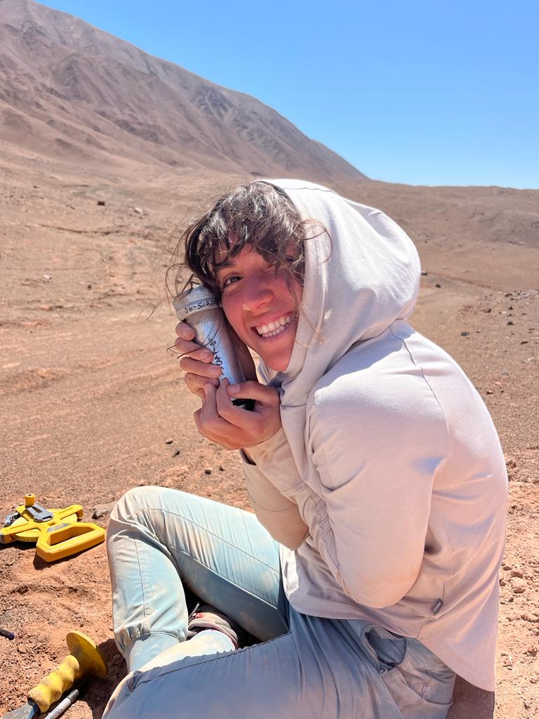 Abstract: The Salar Grande Fault (SGF) is a dextral-oblique fault system within the northern segment of the Atacama Fault Zone (AFZ), in Northern Chile. The study area is immersed in hyper-arid desert conditions (< 2 mm/year rainfall), with excellent surface preservation markers indicating strike-slip fault motion. The region sits within one of the most active subduction zones in the world, where future magnitude 9 earthquakes from the megathrust and tsunami waves up to 30 m are expected to impact the coastal towns. Reconstructing the landscape evolution of the SGF is essential to understand the role of crustal faults in subduction zone settings and the interaction between deeper tectonics and surface processes.
  Abstract: Marine sedimentary deposits along the Cascadia margin have long been a source for insight into historical events and processes including: seismic recurrence; floods, storms and other oceanographic processes; and geochemical exchanges in the Pacific Northwest. This history is accessed through sediment core collection and analysis (210Pb geochronology, grain size analysis, imaging, tracers). Prior studies have implemented these methods over segments of the Washington Margin, but gaps in core coverage preclude a comprehensive view of the margin. Recent core data collected from upper Astoria Canyon have proven that modern hydrodynamics are capable of flushing sediment to depths far greater than initially anticipated, but this study was not able to constrain the depth of the canyon depocenter. These dual factors have spurred new interest in a coring survey over this coverage gap with two goals: