Introduction
Gap analysis, which uses land cover, wildlife habitat relationship models, and other data to predict the distribution of terrestrial vertebrates, provides information which can be applied to landscapes and regions in order to ensure that land management and land use plans more effectively incorporate the protection of biodiversity. Although the data from the Washington Gap Analysis Project (WAGAP) have been summarized and analyzed at the statewide level, the analysis was conducted using ecoregions and vegetation zones. This approach to interpreting the data is useful for many applications; however, with regard to county land use planning, ecologically determined units do not translate well to politically determined boundaries. The WAGAP data were therefore significantly manipulated, analyzed, and re-interpreted before they were applied to the county land use planning process. The methodologies described in this handout were developed through a pilot implementation project in Spokane County, Washington and were created in an attempt to link biological knowledge to the County’s Critical Areas Ordinance and Compre-hensive Plan.
Spokane County is currently engaged in updating its Comprehensive Plan as required by the Washington Growth Management Act (RCW 36.70A). The current County plan includes goals calling for the identification, improvement, and protection of fish and wildlife habitat. Additionally, the plan calls for the minimization of habitat fragmentation by protecting important fish and wildlife areas and open space and by interconnecting corridors to form a continuous network of fish and wildlife habitat and ecosystems. Furthermore, the County’s Critical Areas Ordinance (CAO) requires the protection of a variety of priority habitats, including wildlife corridors and landscape linkages. The County was interested in developing a method for locating and identifying these priority habitats, and chose to enter into a pilot WAGAP implementation project involving the Washington Department of Fish and Wildlife, the Inland Northwest Land Trust, and the University of Washington (Department of Urban Design and Planning and the Washington Cooperative Fish and Wildlife Research Unit).
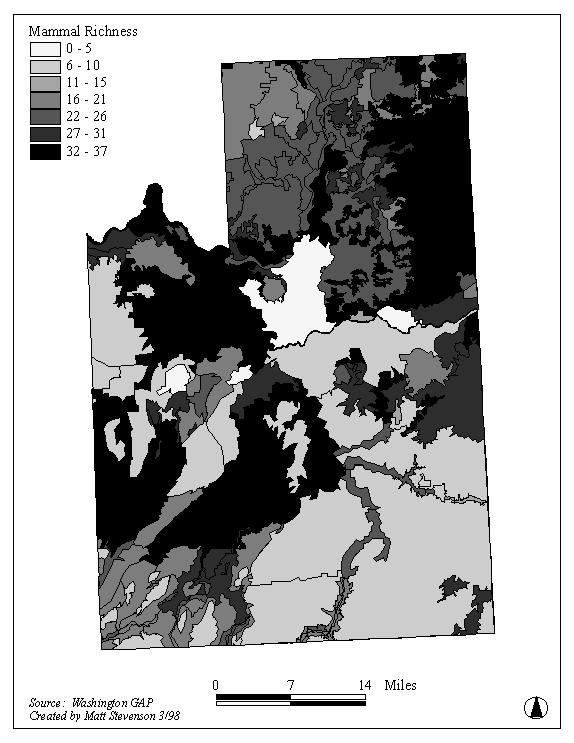
Figure 1: Mammal species richness
Methods
The protection of biodiversity was chosen as the design strategy for locating and delineating wildlife corridors and landscape linkages in Spokane County because it is the most effective way to ensure the realization of the goals dealing with fish and wildlife in the CAO. Furthermore, planning for biodiversity before species become endangered can help to prevent the imposition of confrontational governmental sanctions as human activity continues to expand into previously undeveloped areas. Representation and richness were the specific methods selected to capture biodiversity at the scale of the entire county.
The purpose of achieving representation is to ensure that every species predicted to occur in the County is recognized at least once by a subset of all the County’s WAGAP polygons. Representation does not necessarily mean that the entire life history of any given species can be accommodated within the representative set of polygons, but does guarantee that all species predicted to occur in the County are included within the representative subset of polygons. Redundancy is built into the process, as the three groups used in the analysis (mammals, birds, and reptiles and amphibians) are combined after representation is established for each individual group. Representation was determined using a modified set coverage approach on WAGAP species distribution data (exemplified in Figure 1). This approach resulted in the map shown in Figure 2, the representative set for all terrestrial vertebrates modeled by WAGAP.
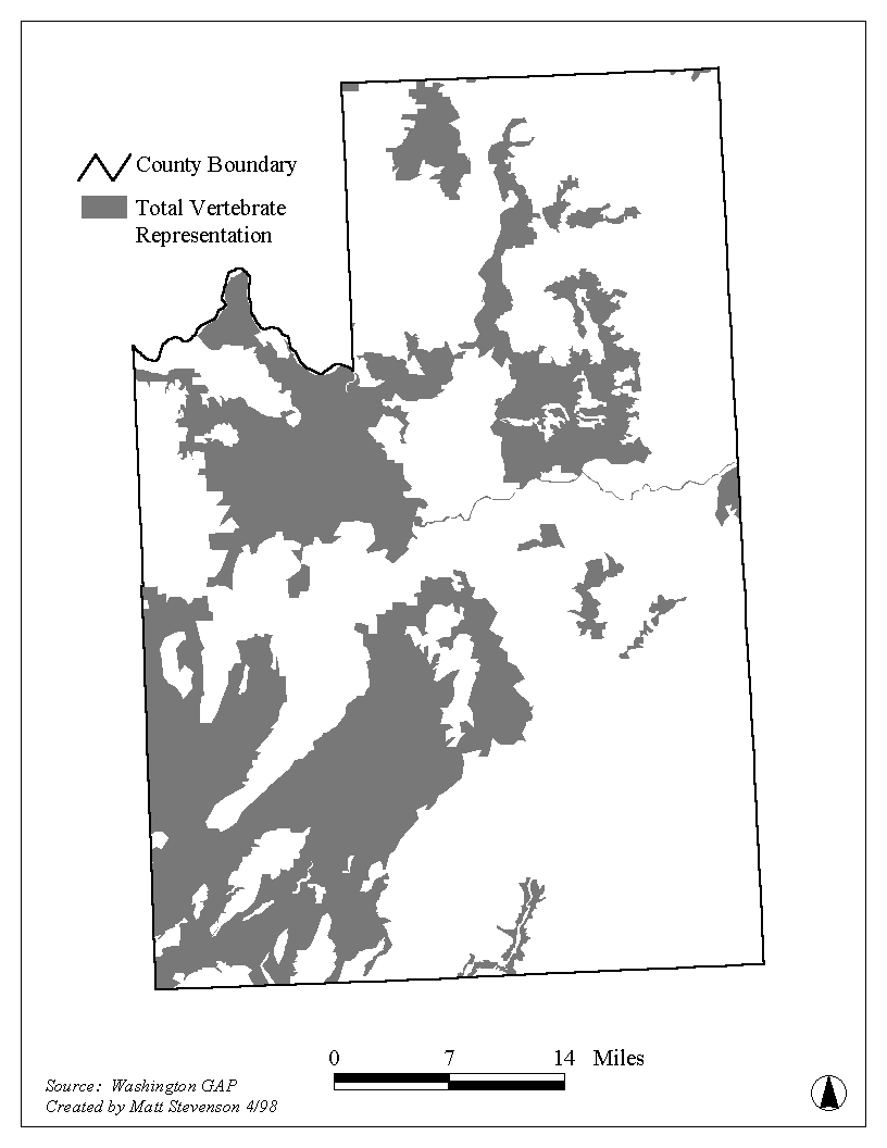
Figure 2: Representative set for all terrestrial vertebrates
Establishing species richness thresholds by taxonomic group was necessary before areas of high species richness could be identified as potential locations for reserves. This process entailed the creation of a decision rule for which polygons should be selected or "turned on," based upon the number of species predicted to be present in each. For this analysis, threshold levels were set at 75 percent of possible richness for mammals and birds and 50 percent of possible richness for reptiles and amphibians. All polygons with high species richness as indicated by the application of the inclusion rule were initially considered for habitat reserve area designation. The ideal polygons for potential habitat reserves were large polygons with high species richness, natural land cover, low internal and adjacent human development, and high levels of agreement with other wildlife distribution databases. Potential habitat reserves for all three groups are reflected in Figure 3.
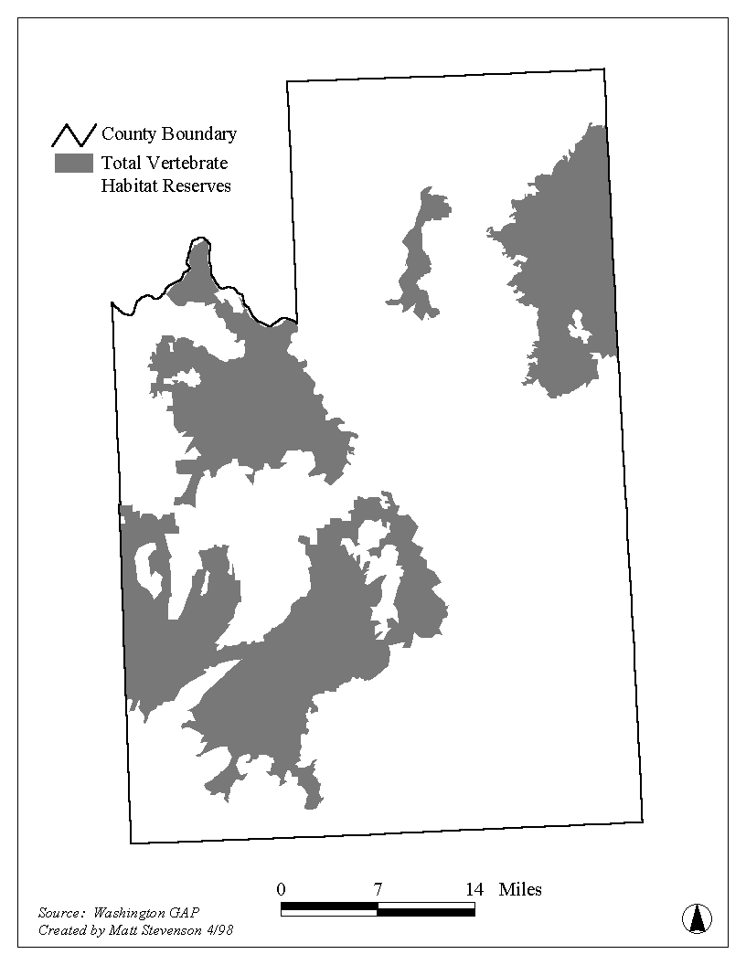
Figure 3: Potential Habitat Reserves for All Terrestrial Vertebrates
Connections between habitat reserves and representative areas were made by identifying and selecting polygons with high species richness and natural land cover between the reserves and representative areas. Maps of species richness, representation, and potential connections between these areas were combined to produce Figure 4, the "raw material" from which a potential wildlife corridor and landscape linkage system might be created. Approximately 48 percent (546,942 acres) of Spokane County is indicated in Figure 4 as being important for protecting biodiversity. This is a tremendous amount of land! In order to refine the areas indicated through the additive process described above, it was necessary to utilize additional sources of information providing a greater level of detail.
These County data sets included a fine-grained land cover map (5 acre minimum mapping unit) of the Interim Urban Growth Area surrounding the City of Spokane and its suburbs; parcels; roads; topography; wetlands and hydrology; land use and zoning; other growth area boundaries; existing critical areas; governmental land holdings; and utility and railroad rights of way.
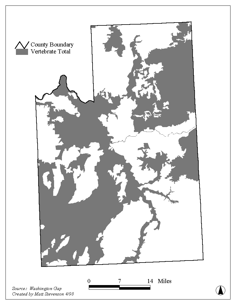
Figure 4: Richness, Representation, and Connections
The final result of the additive process of determining representation, richness, and creating connections and the reductive process of refining this result is shown in Figure 5. This proposed system comprises only 30 percent of the county, a substantial reduction from the initial 82 percent indicated at the end of the additive process.
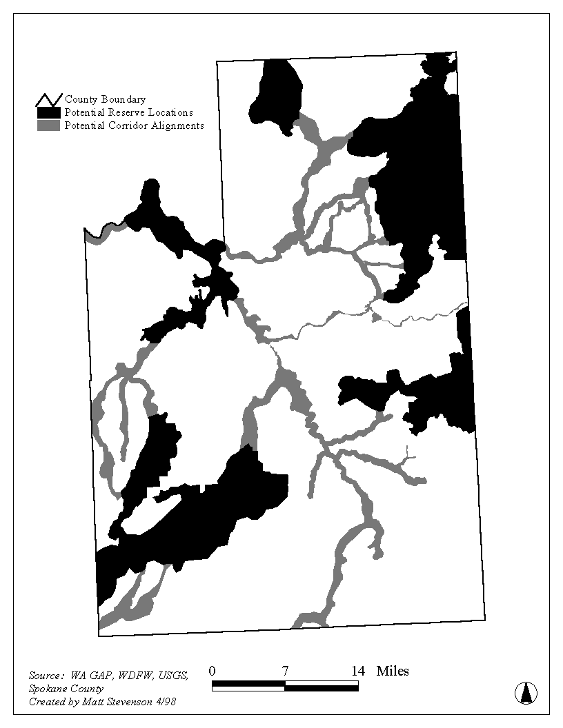
Figure 5: Potential Reserve and Corridor Locations
Results
If the system of wildlife corridors and habitat reserves shown in Figure 5 were implemented with no substantial modifications, all vegetation zones within the County would see a minimum 10 percent increase in protected area in addition to already protected land. Protection for the largest vegetation zone in the County, Ponderosa Pine, would increase by 26.5%. For vertebrate species, birds, mammals, and reptiles and amphibians would see median increases in protected areas of 38, 39, and 43 percent, respectively. (Once again, this is in addition to land already designated for the protection of biodiversity). These increases result in a combined median increase of 39 percent for all terrestrial vertebrates. It should be noted that this 39 percent increase occurs on only 30 percent of the County’s total land area.
Discussion
To successfully utilize the findings from this analysis, Spokane County (and any other municipalities interested in conducting similar analyses) will have to employ a wide variety of tools. There is no single mechanism by which the biologically significant lands in Spokane County can be instantly and unilaterally protected in perpetuity; indeed, even if there were, it might not be desirable to protect biodiversity in this manner. Rather, a combination of incentives, regulations, and acquisitions is the approach most likely to achieve the goals established in the CAO.
Presently, Spokane County is using the results of the pilot project to update their Comprehensive Plan and Critical Areas Ordinance. The Washington Department of Fish and Wildlife is using the information to analyze and evaluate properties proposed for acquisition under the voter-approved Conservation Futures program. The Inland Northwest Land Trust is using the data as the centerpiece of their land protection work this year, and intends to do so for the foreseeable future.
Remote Sensing Applications Laboratory - University of Washington Department of Urban Design and Planning, Box 355740, Seattle, WA 98195
URL: http://depts.washington.edu/rsal/GAP/spokane_brochure.html
Contact: RSAL
Brochure Content by: Matt Stevenson, 1998
Last modification: 11/19/98 (dcp)
.