Data and credits
Explanatory notes:
These are preliminary findings and our research is not complete. We are grateful to the King County Archives for providing access to records, some in digital form. We also scanned more than 1 million property records from microfilm.
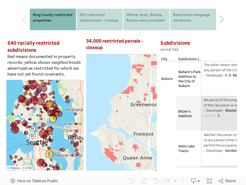
Subdivisions shown in red were restricted in documents we have found. Those in yellow are suspected because we have found newspaper advertising claiming that these neighborhoods were "restricted," but have not yet found full documentation.
There is a logic to the geography. Areas platted (subdivided) between 1925 and 1948 were most likely to be restricted. Realtors and developers wrote racial exclusions into the initial documents subdividing a future neighborhood. All properties in the subdivision were thus legally restricted. That is how so many north Seattle, south Seattle, and suburban tracts came to be restricted. It was more complicated to restrict older areas. Neighborhood associations organized petition drives and convinced white homeowners to add racial restriction clauses to their properties in Capitol Hill, Madison Park, Queen Anne, Magnolia, and parts of Madronna.
Look at the language of restriction in these deeds. Some specify that neighborhoods are reserved for "Whites," while others enumerate the prohibited racial groups. And the wording is curious. In the terminology of the 1920s-1940s "Hebrews" meant Jews; "Ethiopians" meant African ancestry; "Malays" meant Filipinos; "Mongolians" meant all east Asians; "Hindus" meant all south Asians. Most shocking is the "Aryans only" restriction imposed on a subdivision in Clyde Hill. That racial concept, favored by Adolph Hitler, was written into deeds as late as 1948.