Isle of Skye, Scotland: a proposed
verification/calibration site
Marc Caffee (Purdue University), Lewis Owen
(University of California), Gary Landis (USGS, Denver) and Douglas Benn
(University of St. Andrews)
The
Cuillin and adjacent mountains on the Isle of Skye (57o15’N/6o15’W)
in Scotland contain the best and most intensely studied Younger Dryas moraine
succession in the world (Walker et al 1988; Ballantyne, 1989; Benn, 1989;
Walker and Lowe, 1990; Ballantyne et al. 1991; Benn et al. 1992). The moraine ages
are well-defined on the basis of palynological and radiocarbon studies of peat
bogs within and beyond the limit of the Loch Lomond Readvance (Younger Dryas)
(Walker et al 1988; Walker and Lowe, 1990; Ballantyne et al. 1991; Ballantyne
et al. 1991; Benn et al. 1992). The Loch Lomond Readvance cirque glaciers and a
small ice cap that formed over the Cuillin Mountains produced a series of
moraine ridges and ice scoured bedrock surfaces that are well preserved
throughout the region (Ballantyne et al. 1991; Benn et al. 1992; Fig. 1). Prior to the Loch Lomond Readvance,
during the Devensian (Last Glacial Maximum and probably up to ~ 15 ka), the
Isle of Skye was essentially covered by the British Ice sheet (Ballantyne et
al., 1998). Peaks higher than 750-870 m in the Cuillins, however, were not
totally covered by the ice sheet and formed small nunataks that rise to 992 m
asl on Sgurr Alasdair, but these are very small in extent (Dahl et al., 1996; Ballantyne et al.,
1998). Recent work on chironomid assemblages at Whitrig Bog in southeast
Scotland provides evidence that temperatures during the Lateglacial in Scotland
agree closely, both in general trends and in detail, with the GRIP ice-core
oxygen-isotope curve (Brooks and Birks, 2000: Fig. 2). Furthermore, similar
chironomid work by Brooks et al. (in progress) at sites in Abernethy Forest
(Cairngorms) and Loch Ashik (Isle of Skye) are confirming that the temperature
changes documented at the Whitrig Bog site are of regional extent. This
supports the view that temperature changes and glacier fluctuations during the
Younger Dryas Stade in Scotland would have been synchronous with δ18O
variations in the Greenland ice sheet. Therefore, we can directly correlate the
ice-core oxygen-isotope stratigraphy with the glacial successions on the Isle
of Skye.
During
a field season in July 2002, we were able to examine the Younger Dryas moraines
and associated landforms on the Isle of Skye. In particular, we examined
potential calibration sites throughout southern Skye and collected a set of
rock samples for terrestrial cosmogenic nuclides (TCN) surface exposure dating
(Figs 3-5). As part of the CRONUS project, we wish to use these samples to help
in calibration and verification of CRN production rates and to use the Younger Dryas
landforms on the Isle of Skye as calibration/verification sites.
There
are several reasons to believe that Younger Dryas glacial landforms on the Isle
of Skye will provide excellent verification/calibration sites:
1.
NW Scotland is very sensitive to changes in Northern Hemipshere/North Atlantic
climate, and since the glaciers on Skye were small they would have responded
rapidly (within a few decades) to climate change. Figure 2 shows that the times
of temperature change in NW Scotland during the Lateglacial and earliest
Holocene correlate with the ice-core data. As such, glacier fluctuations on
Skye almost certainly were synchronous with variations in the δ18O
values in the Greenland ice sheet. We can, therefore, correlate individual
moraine ridges to distinct δ18O excursions in the Greenland
ice-cores during the Younger Dryas Stade. In doing so, we can subdivide the
Younger Dryas Stade from a simple 1300 year time span (11.6-12.9 ka) to
centennial events during which distinct sets of moraines formed. Given that
cirque glaciers have response times of decades, we can therefore assume that
the maximum extent of small glaciers on Skye dates to the coldest part of the
Stade, when equilibrium-line altitudes (ELAs) were lowest. As such, the outer
most moraine ridges would have likely formed at ~12.5±0.2 ka. Similarly the
inner most moraines and ice-scoured bedrock surfaces near the heads of
glaciated valleys should date to the timing of the final deglaciation at ~11.6±0.1 ka (cf. Fig. 2). The
new work being undertaken by Brooks et al. (in progress) on the chirominid
record on sediments from Abernethy Forest and Loch Ashik will help substantiate
and refine the timing of climate changes and glaciation on the Isle of Skye.
The presence of the Vedde Ash in the deposits at Loch Ashik (Davies et al.,
2001) can be used to reduce the uncertainty in radiocarbon dating undertaken on
the sediment, further increasing the accuracy of the paleoclimatic
interpretations.
2.
TCN dating can be undertaken on a variety of lithologies, including granites,
sandstones, basalts and gabbros, that contain suitable cosmogenic target
minerals. This will allow us to study multiple TCNs on different rock types
(Fig. 3). As the region is sufficiently small, asynchronous glaciation did not
occur, , and so comparison of moraines and different lithologies between nearby
valleys is possible.
3.
Inheritance of TCNs should not be a major problem because the British ice sheet
should have eroded sufficient amounts of rock during the Devensian to minimize
exposure inheritance. We anticipate TCN nuclide inheritance in bedrock
lithologies to be at most comprised of very minor deeper muonogenic and
nucleogenic/radiogenic crustal nuclides typical of shielded rocks. The present
precipitation on Skye is ~3000 mm a-1, and estimates based on
preliminary chironomid/glacier ELA work indicate that precipitation was similar
during the Younger Dryas (Brooks et al., in progress). Thus, mass turnover was
high and glaciers were clearly wet based, fast-flowing, and were likely to have
been highly erosive. Where Loch Lomond readvance glaciers flowed at a high
angle to the Devenisian ice flow direction (e.g. Coir' a Ghrunnda, Coire
Lagan), there are no Devensian striae or roche moutonnee forms left. Therefore
we know that the Younger Dryas glaciers eroded away the Devensian surface and
inheritance should be insignificant. We will date Devensian moraines and ice
scoured bedrock, however, to define the timing of Devensian deglaciation on
Skye to be certain of the duration between deglaciation and the Loch Lomond
Readvance. This will help assess
the magnitude of inheritance. There is of course the problem that
boulders from the Devensian glaciation could be incorporated into Younger Dryas
moraines. However, we can easily assess the degree of likely inheritance by
examining the lithologies of the moraines. Moraines with any significant
inherited Devensian boulders would be apparent because they would contain
numerous lithologies foreign to the local glacial catchments that were eroded
during the Younger Dryas Stade. During our pilot study we did not find
significant foreign boulders in any of the moraines that we studied.
Furthermore careful sampling of boulders based on a knowledge of the catchment
and glacial sedimentology can reduce this problem (cf. Benn, 1989).
4.
Corrections for shielding due to snow cover are not necessary. Due to the
maritime climate on Skye, snow does not persist for more than a few days a
year, and it is unlikely that it was any more abundant during any time
throughout the Holocene.
5.
Holocene rates of weathering in this region are extremely low (cf. Ballantyne,
1994; Stone et al., 1998) and therefore corrections for weathering are small or
negligible. Erosion rate scaling corrections (including moraine sediment
shielding) will not seriously alter TCN age calculations.
6.
The isostastic rebound is well defined for the region and therefore corrections
for altitudinal changes can be be easily determined (Benn, 1991). A prominent
rock platform just above sea level is present beyond the Younger Dryas glacier
limits (ibid). This is thought to be equivalent to the Main Rock Platform that
is present elsewhere in Scotland and is dated to the Younger Dryas Stade
(ibid). The net sea-level change on Skye since the Younger Dryas is close to
zero, which indicates 60±10 m of surface uplift during the last ~11 ka. Using
the modeling of Lambeck (1993a and b) we will be able to determine the rate of
surface uplift to make the appropriate altitude corrections. Furthermore, we
can use the rock platform as another calibration site, yet the uncertainty of
its age (11.6-12.9 ka) is larger than that of the moraines. However, dating
this rock platform will provide confirmation that it formed during the Younger
Dryas Stade and that we are certain about the uplift rates.
7.
The region is extremely accessible and there are no restrictions on land access
or scientific research.
On
each of the samples already collected, we plan to measure 10Be, 26Al,
36Cl at Purdue University and 21Ne and 3He at
the USGS. The TCN ages will be calculated and compared with the known ages on
the moraines to refine the TCN production rates. The data we collect will also
provide us with an intercalibration between the various TCNs.
Using
the data from the pilot study we will return to the field area during the
summer of 2004 and resample from sites that were particularly successful in the
initial study. This will help us refine the results. Presently we have about
five samples per moraine ridge within each of the study areas. Collecting up to
15 samples from selected moraine ridges will help reduce the statistical
uncertainty of our results. We will also survey, using an electronic distance
meter at a precision of 1-10cm, several of the moraine ridges to map their
shape and we will collect boulders from different positions on the moraines to
examine if there are significant variations in the CRN ages dependent upon
sampling positions. This will help us test models for moraine degradation such
as proposed by Hallet and Putkonen (1994). We should also like to sample some
of the bedrock surfaces in more detail, for example, to compare areas of
plucking from areas of abrasion to test for cosmogenic, nucleogenic, and
radiogenic inheritance in bedrock and to quantify shielding or glacial erosion
depths.
We
will require support for 1) a graduate student (based at Purdue University, but
who will also work at the USGS in Denver), 2) consumables incurred with mineral
separation and mass spectrometer analysis, 3) costs of AMS measurements, 4) and
travel for three weeks field work on Skye and to CRONUS meetings for each of
the PIs.
REFERENCES
Ballantyne, C.K. (1989) The Loch Lomond Readvance on the Isle of Skye, Scotland: glacier reconstruction and paleoclimatic implications. Journal of Quaternary Science, 4, 95-108.
Ballantyne, C.K. (1994) Gibbsitic soils on former nunataks: implications for ice sheet reconctruction. Journal of Quaternary Science, 9, 73-80.
Ballantyne, C.K.(1998) Aeolian deposits on a Scottish mountain summit: characteristics, provenance, history and significance. Earth Surface Processes and Landforms, 23, 625-641.
Ballantyne,
C.K., Benn, D.I., Lowe, J.J. and Walker, M.J.C. (1991) (eds) The Quaternary
of the Isle of Skye: Field Guide. Cambridge: Quaternary Research Association.
Ballantyne,
C.K., McCarroll, D., Nesje, A., Dahl, S.O. and Stone, J.O. (1998) The last ice
sheet in North-West Scotland: reconstruction and implications. Quaternary
Science Reviews,
17,
1149-1184.
Ballantyne,
C.K., McCarroll, D., Nesje, A., Dahl, S.O., Stone, J.O. and Fifield, L.K.
(1998) High-resolution reconstruction of the last ice sheet in NW Scotland. Terra
Nova, 10, 63-67.
Ballantyne,
C.K., Stone, J.O. and Fifield, L.K. (1998) Cosmogenic Cl-36 dating of
postglacial landsliding at the Storr, Isle of Skye. The Holocene, 8, 347-351.
Benn, D.I.
(1989) Debris transport by Loch Lomond Readvance glaciers in Northern Scotalnd:
basin form and the within-valley asymmetry of lateral moraines. Journal of
Quaternary Science,
4,
243-254.
Benn, D.I.
(1991) Raised shorelines on Skye. In: Ballantyne, C.K., Benn, D.I., Lowe, J.J.
and Walker, M.J.C. (eds) The Quaternary of the Isle of Skye: Field Guide. Cambridge: Quaternary
Research Association, p. 90-97.
Benn, D.I. and
Ballantyne, C.K. (2000) Classic Landforms of the Isle of Skye. Geographical
Association, Sheffield, 56pp.
Benn, D.I.,
Lowe, J.J. and Walker, M.J.C. (1992) Glacier response to climatic change during
the Loch Lomond Stadial and early Flandrian: geomorphological and palynological
evidence from the Isel of Skye, Scotland. Journal of Quaternary Science, 7, 125-144.
Brooks, S.J.
and Birks, H.J.B. (2000) Chironomid-inferred Late-glacial air temperatures at
Whitrig Bog, southeast Scotland. Journal of Quaternary Science, 15, 759-764.
Brooks, S.J.,
Birks, J., Birks, H., Ballantyne, C.K. and Benn, D.I. (in progress) Reconstruction of
climatic change and climatic gradients across the Scottish Highlands during the
Loch Lomond (Younger Dryas) Stade.
Dahl, S-O.,
Ballantyne, C.K., McCarroll, D. and Nesje, A. (1996) Maximum altitude of
Devensian glaciation on the Isle of Skye. Scottish Journal of Geology, 32, 107-15.
Davies, S.M.,
Turney, C.S.M. and Lowe, J.J. (2001) Identification and significance of a
visible, basalt-rich Vedde Ash layer in a Late-glacial sequence on the Isle of
Skye, Inner Hebrides, Scotland. Journal of Quaternary Science, 16, 99-104.
Hallet, B. and
Putkonen, J. (1994) Surface dating of dynamic landforms: young boulders on
aging moraines. Science, 265, 937-940.
Lambeck, K.
(1993a) Glacial rebound of the British Isles. I: Preliminary model results. Geophysical
Journal International,
115,
941-959.
Lambeck, K.
(1993b) Glacial rebound of the British Isles. II: A high resolution, high
precision model. Geophysical Journal International, 115, 941-959.
Stone, J.O.,
Ballantyne, C.K. and Fifield, K. (1998) Exposure dating and validation of
periglacial weathering limits, N.W. Scotland. Geology, 26, 587-590.
Walker, M.J. and Lowe, J.J.
(1990) Reconstructing the environmental history of the Last Glacial-Interglacial
Transition: evidence from the Isle of Skye, Inner Hebrides, Scotland. Quaternary
Science Reviews, 9, 15-49.
Walker, M.J., Ballantyne,
C.K., Lowe, J.J. and Sutherland, D.G. (1988) A reinterpretation of the
Lateglacial environmental history of the Isle of Skye, inner Hebrides, Scotland.
Journal of Quaternary Science, 3, 135-146.
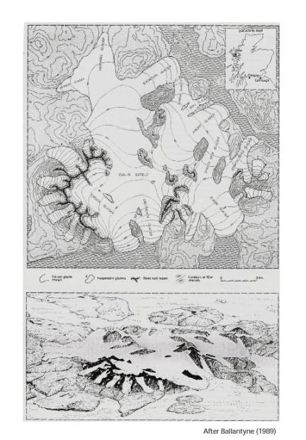
Figure 1:
Location and reconstruction of the Younger Dryas glaciers in the Cuillin
Mountains of the Isle of Skye (after Ballantyne, 1989).
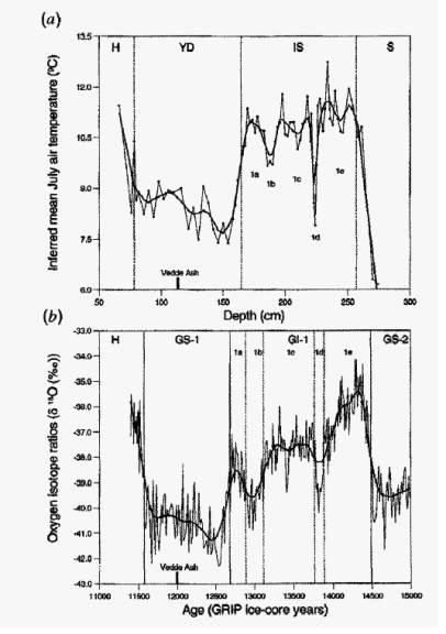
Figure 2: a)
Chironomid-inferred mean July air temperatures (oC) at Whitrig Bog
during the Lateglacial and earliest Holocene compared with b) the GRIP ice-core
data (after Brooks and Birks, 2000). Both data sets show that the Younger Dryas
Stade can be subdivided into distinct warmer and colder times. The Vedde Ash
provides confidence in the radiocarbon dating at Whutrig Bog and can also bee
found in Loch Ashik in the Isle of Skye (Davies et al., 2001)
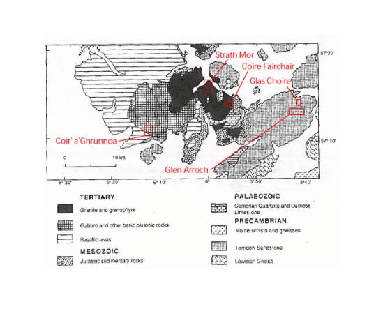
Figure 3: The
geology of southern Skye and the locations of the detailed study areas that we
examined in our pilot study (after Ballantyne et al., 1991). Some of these
study areas are shown in Figures 4 to 6. these illustrate the nature of the
glacial geology and the locations of some of the samples that we have already
collected.
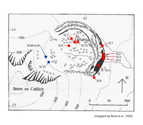
Figure 3: CRN
sampling sites on moraine boulders (red) and ice-scoured bedrock (blue) in
Coire Fearchair on the granite hills of Beinn na Caillich (mapping after Benn
et al., 1992). These moraines were formed by a small cirque glacier during the
Younger Dryas Stadial. The outermost moraines, on which samples SC1 to SC6 were
collected, probably formed during the early part of the stadial (12.5±0.2 ka).
Samples SC7 to SC10 and SC68 to S70 were collected from the inner moraines and
ice-scoured bedrock, respectively. These represent the final stage of
deglaciation (11.6±0.1 ka).
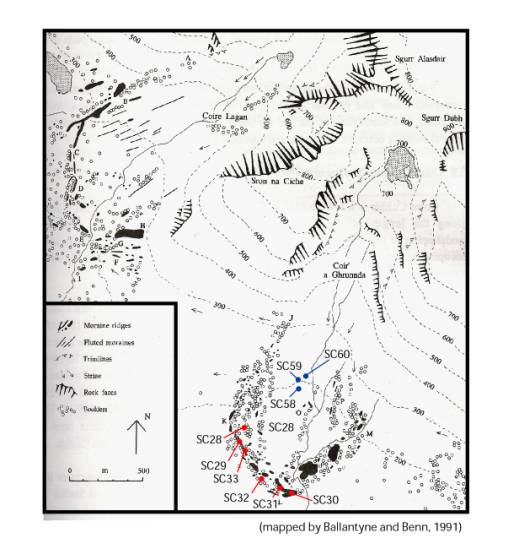
Figure 4: the
locations of CRN sampling sites on the gabbro hills of the Cuillins at Coir’
a’Ghrunnda. Samples SC28 to SC30 were collected from boulders on moraine crests
that probably formed during the early part of the Younger Dryas Stadial at
12.5±0.2 ka. Samples from ice-scoured bedrock (SC58-SC60) should date to
11.6±0.1 ka when Younger Dryas glaciers finally retreated.
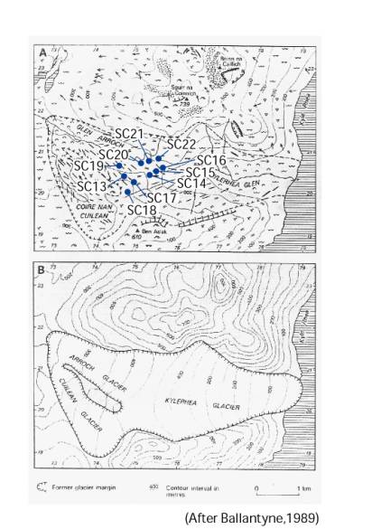
Figure 5: A)
Sampling sites on ice-scoured sandstone an ice-divide in the Kyleakin Hills.
These samples should represent the final retreat of the Younger Dryas glacier
at 11.6±0.1 ka. The samples were collected from ice plucked zones of roche
moutonnees and on ice-polished surfaces. B) Reconstruction of the former
glaciers (after Ballantyne, 1989).