Timeline and Map of Woman Suffrage Legislation State by State 1838-1919
by Katie Anastas
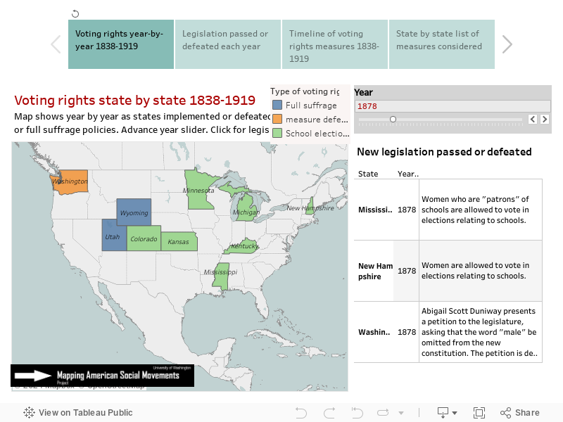
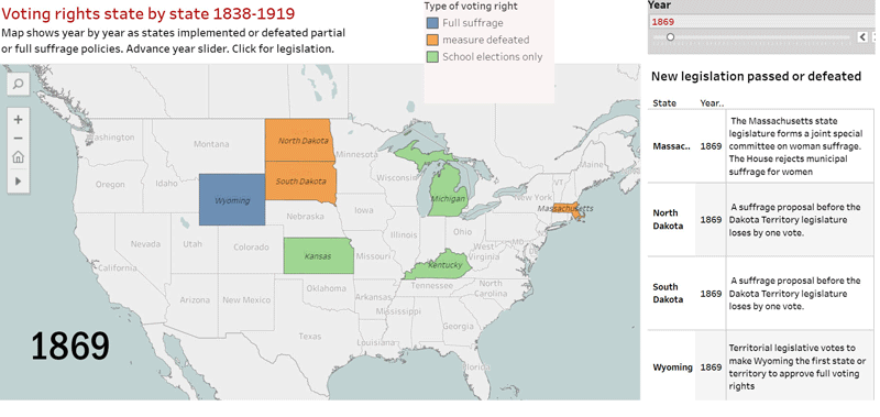
Voting rights by states 1869-1919. Blue means full rights. Green indicates partial suffrage. Orange means voting measure was rejected by legislature or electorate. Below are fully interactive timelines and maps.
The interactive maps below show the woman suffrage campaign year-by-year and state-by-state from 1838-1919 as suffrage activists introduced legislation that often failed and at other times yielded only partial voting rights. Ratified in 1920, the 19th Amendment to the US Constitution required all states to allow women to vote on the same basis as men, but the fight for voting rights had started more than a century earlier and had steadily piled up victories beginning in 1838 when the Kentucky legislature agreed that widows and unmarried women who owned property subject to taxation for school purposes would be allowed to vote in elections relating to schools.
Starting in 1869, legislation was introduced in one or more states nearly every year. The timeline and maps below record the defeats as well as victories, demonstrating the persistence and ingenuity of suffrage activists. They show too that many state legislatures were persuaded to allow partial voting rights, typically limited to school elections or the right to vote only in municipal or presidential elections. Here we track the outcome of 249 measures and the changing map of voting rights for women. The maps are hosted by Tableau Public and may take a few seconds to respond. If slow, refresh the page.
Move between four maps and timelines (best on laptop or larger screen)
Research and data compilation: Katie Anastas
Maps: James Gregory
Sources:
Harper, Ida H., ed. History of Woman Suffrage. Vol. 6. New York: National American Woman Suffrage Association, 1922.
History of Woman Suffrage was edited by Elizabeth Cady Stanton, Susan B. Anthony, Matilda J. Gage, and Ida H. Harper. It was published by the National American Woman Suffrage Association in six volumes. Volume six is divided into chapters by state. The authors describe legislative decisions and the activities of suffrage organizations year by year. This volume was accessed through the “Women and Social Movements in the United States, 1600-2000” site from Alexander Street Press, edited by Kathryn Kish Sklar and Thomas Dublin.
Keyssar, Alexander. The Right to Vote: A Contested History of Democracy in the United States. New York: Basic Books, 2000. Print.
In this book, Alexander Keyssar discusses how voting rights have changed throughout American history. Included in the woman suffrage section is a list of years when states allowed women to vote in school elections, municipal elections, and presidential elections prior to the Nineteenth Amendment.
Lunardini, Christine. From Equal Suffrage to Equal Rights: Alice Paul and the National Woman’s Party, 1910-1928. New York: toExcel, 1986. Print.
This book focuses on Alice Paul and the National Woman’s Party. The first chapter of the book, titled “Breaking with the Past: The New Suffragists,” discusses the National American Woman Suffrage Association’s early work outside of Washington D.C. as individual states began to enfranchise women.
Mead, Rebecca J. How the Vote Was Won: Woman Suffrage in the Western United States, 1868-1914. New York: New York University Press, 2004. Print.
In this book, Rebecca Mead discusses tactics, victories, and shortcomings of the early suffrage movement in the Western U.S., including California, Oregon, Washington, Montana, and Nevada. She explains suffragists’ reliance on support from labor groups, socialists, and the working class in states like California, and outlines voting patterns in several legislative events in each state.
Pearce, Stella E. “Suffrage in the Pacific Northwest: Old Oregon and Washington.” The Washington Historical Quarterly, vol. 3, no. 2, 1912, pp. 106–114
This journal article by Stella Pearce provides a history of early suffrage laws in the territories of Oregon and Washington, beginning in 1840. Pearce explains each suffrage law and major legislative decision.
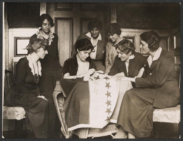
This illustrated essay chronicles the actions and accomplishments of this remarkable social movement while displaying more than 50 photographs from the "Women of Protest: Photographs from the Records of the National Woman's Party" (Library of Congress).
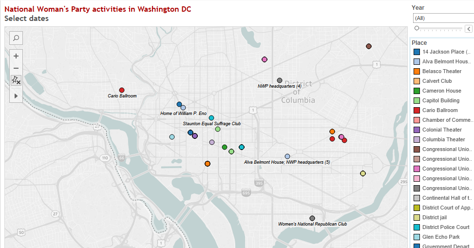
From the beginning, the NWP focused tightly on Washington DC. It's first headquarters was some distance from the Capitol, but as soon as finances permitted, NWP moved closer, a mere block from the White House. These maps and timeline show the locations of picket lines, arrests, and meetings in the nation's capital.
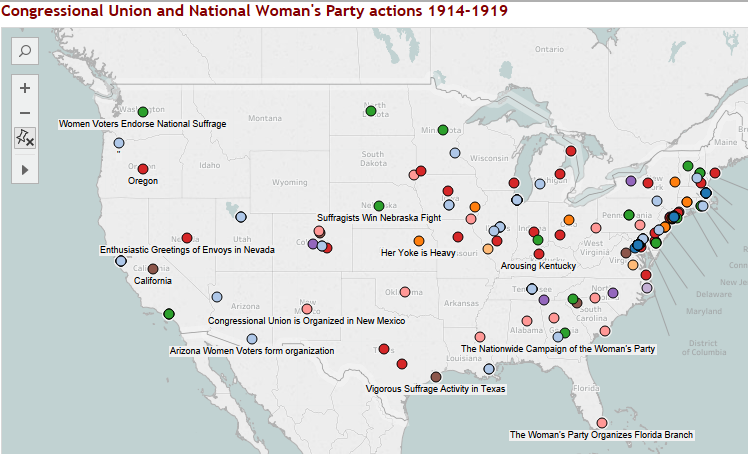
Here are maps and charts showing the year-by year geography of the the movement. The NWP organized campaigns in many states while concentrating protest activities in Washington DC. Filter by state and by the type of events.

 Voting rights by states 1869-1919. Blue means full rights. Green indicates partial suffrage. Orange means voting measure was rejected by legislature or electorate. Below are fully interactive timelines and maps.