Back to Dunhuang
Dunhuang as a Military Outpost
Back to Dunhuang |
Dunhuang as a Military Outpost |
The physical geography of Dunhuang, its region, and the approaches to it help to explain why the town became so important militarily. The most logical route from the interior of China to the West moves through the "funnel" of the Gansu or Hexi Corridor, bounded on north and south by mountains. The mountains to the south are high enough to serve as barriers to invasion, and their glaciers fed the streams which made habitation in an otherwise dry region possible. To the north, the terrain is less well defended by nature; it was for this reason that, beginning in the last centuries BCE, the rulers of China began to create the "Great Wall," to defend against nomadic incursions. The Han emperors, especially beginning with Wu-Ti (141-87 BCE) extended the wall and its network of watchtowers along the Hexi corridor, through the "bottleneck" at Jiayu Guan (later to be the western boundary of China under the Ming) along both sides of the broadening valley past Anxi and well beyond Dunhuang. The British explorer Aurel Stein made the exciting discovery that the Han "limes" extended all the way to Lop Nor, the salt lake at the edge of the Taklamakan Desert.
While it was possible for invaders to break through the defenses to the east of Dunhuang, the fortifications there in a real sense were the gateway to inner China. Even at the greatest extent of Chinese power in Inner Asia in the period up to the end of the first millenium CE, Chinese control beyond Dunhuang was exercised largely through vassal states. Written records indicate that Chinese travelers to the West clearly sensed they had stepped into another world at the moment they passed through the "Jade Gate." To go beyond was to leave behind the comforts of home and to enter culturally alien lands. Except for the garrisons manning the watch towers and small forts, Chinese armies almost inevitably retreated behind the defenses, often in disarray from their inability to provision themselves adequately on long stages through the desert.
The resources invested in maintaining the defenses were substantial and the wisdom of such expense obviously was much debated at the Chinese court. Han narrative histories make it clear that the commitment to the defensive lines fluctuated--at times the walls were allowed to decay, and there was the temptation of agreements with submissive neighbors to allow them to man the defenses. Hiring of mercenaries seems to have been quite common; at the same time, the soldiers sent out from the center of the empire were provided with agricultural land to maintain themselves, although apparently not always adjacent to where they actually served. The supply of food to the more remote outposts was through a highly bureaucratized quartermaster corps, whose records have been unearthed in the ruins of the watchtowers.
The military architects of the fortifications deserve high marks for their skill and ability to take advantage of the local terrain and building materials. While our image of the Great Wall derives from those sections built in stone in the mountains north of Beijing, in the Dunhuang region, the construction material tended to be pounded earth layered with reed mats or grids to provide stability. The arid conditions have helped ensure the survival of major sections of the wall, forts and beacon towers. Sections of the wall retreat into the distance in an absolutely straight line; in general an effort was made to maximize the strategic advantage provided by naturally occurring ridges and hills or swamps and rivers. Generally beyond the wall, in "no man's land," beacon towers commanded heights or passages through the valleys which erosion had carved through the mountain barrier.
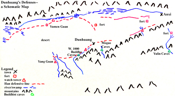
Perhaps the most impressive thing about the physical remains of the defenses in the Dunhuang region is how extensive they are. Beginning in Anxi, to the east of Dunhuang and moving to the west and southwest of the city, a distance of some 250 km., there are extensive sections of wall, dozens of watchtowers, and many ruins of forts or supply depots, most apparently dating from Han times. This image map displays the lines of the Han fortifications (as attested by their remains). For images and some further explanation regarding individual sections of the defenses, click on various "live" locations on the map. Quite extensive material has been provided for the region west of Dunhuang.
|
|
For centuries, a significant portion of the traffic between the Chinese heartland and inner Asia was funneled through Dunhuang. The reign of Emperor Wu-ti marked the beginning of a campaign of aggressive Han expansion to the West in order to combat the nomadic Hsiung-nu. The Hexi Corridor came under Han control as a result of battles in 121 and 119 BCE; in 111 BCE a decree established the Dunhuang commandery, whose 2000 soldiers were establish a military colony and extend the fortifications beyond the city. It seems clear though that the more distant units on the edge of the desert wastes could not have been engaged in any significant productive agriculture, given the forbidding natural conditions. The culmination of these successful military campaigns was a victory by Han armies as far west as the Ferghana Valley in 101 BCE. By the year 9 CE, a census recorded some 11,200 households in Dunhuang.
Stein's discovery of documents (mainly written on strips of wood) in the ruins of the fortifications at the "Jade Gate" (Yumen guan), which controlled the road to the West, confirms the chronology of Dunhuang's early history, as a number of them date from the 90s BCE. At the watchtower farthest west along this defensive line, Stein found records dating from around 60 BCE, precisely the period when other documentation tells of the establishment of the Han Protectorate General for the Western Regions and the further extension of the system of military colonization.
Of course, as we know, Han fortunes in the West fluctuated and along with them the extent of firm military control. Stein determined that in the area around the "Jade Gate" a secondary line of fortifications came into being during the period of the usurper Wang Mang (9-23 CE), confirming other evidence to the effect that during this period of weakness, the Han pulled back from their forward positions further to the West. This is precisely the period when we know the Hsiung-nu were able to a degree to reassert their control in areas of the Western Regions. The Han reasserted their control in the Tarim Basin in the last three decades of the first century CE but again pulled back, due to fiscal exigencies, beginning in 107. Without attempting here to fill in additional details of the chronology of the defensive lines in the immediately succeeding centuries, we would merely point out that the archaeological evidence documents the continuing traffic through the Jade Gate in the T'ang period.
© 1999 Daniel C. Waugh