
This page best viewed at screen resolution 1024 x 768, not 800 x 600.
Select an Image Gallery:
Click on thumbnails to enlarge them


Traversing as they do all of Eurasia, the Silk Roads encompassed almost every climate and vegetation zone and crossed every kind of terrain. This sketch of Silk Road geography has the modest aim of introducing a few of the important features of Eurasian physical geography which help us to understand patterns of human habitation and interaction across that vast expanse. There are always regional variations which deserve more detailed treatment. Before the advent of modern technology, geography and ecological zones were critical determinants of where and how people lived, moved and interacted. Boundaries such as we know them, delineated by modern states, did not exist, but boundaries there were, either natural or manmade, and in both cases they turn out to have been quite permeable.
We might start by asking whether to generalize in part on the basis of the geography as we know it today is valid for earlier millennia. Today we hear a great deal about climate change. Climate change certainly occurred historically, often, it seems, with major consequences for patterns of life on earth. While in many areas of Inner Asia an approximation of the climate patterns familiar today became established some 3000 years ago, there nonetheless have been short term and regional variations which affected movements of peoples, their economic livelihood and ability to live in particular locations, changes in trade routes and the like. The first section of this essay will treat geographical and climate factors more or less as constants. The second section will explore what we are learning from recent studies concerning climate change.
Land and people
Perhaps the most important feature of Eurasia's geography is the sheer size of the land mass, stretching as it does some 7500 km. from the Mediterranean to the China Sea and some 5000 km. from the Indian to the Arctic Oceans. This means not only that climate may range from tropical (very hot) to arctic (very cold) but, perhaps more importantly, much of the land mass is distant from large bodies of water which may exercise a moderating influence on climate and be a source of moisture. The key to understanding locations of human activity along the Silk Roads is water (or its absence), for neither man nor his animals can live without it. To a considerable degree, the farther one is from open water (seas, oceans), the drier the climate; this consideration is clearly evident in the geography of the heart of Eurasia through which the Silk Roads passed.
)
)
)
) A glance at a map and satellite imagery shows vast stretches of the inner parts of Asia dominated by mountains and desert. The mountains include some of the highest in the world. Around the year 400, a Chinese monk named Faxian traveled to India through the Karakorum Range and noted the dangers of the route:
A glance at a map and satellite imagery shows vast stretches of the inner parts of Asia dominated by mountains and desert. The mountains include some of the highest in the world. Around the year 400, a Chinese monk named Faxian traveled to India through the Karakorum Range and noted the dangers of the route:
The snow rests on them both winter and summer. There are also among them venomous dragons, which, when provoked, spit forth poisonous winds, and cause showers of show and storms of sand and gravel. Not one in ten thousand of those who encounter these dangers escapes with his life.
In fact though, were it not for those snow-covered mountains, there would be no life in Inner Asia, for they store in their snow and glaciers the moisture which feeds the rivers that make agriculture in the lowlands possible.
)
)
)
)
The Franciscan, John of Plano Carpini's observations from the 13th century are relevant here:
In some parts the country is extremely mountainous, in others it is flat, but practically the whole of it is composed of very sandy gravel...[and] is completely bare of trees. Not one hundredth part of the land is fertile, nor can it bear fruit unless it be irrigated by running water....
)
)
)
) He is describing the Gobi - that vast gravel desert of northern Central Asia, which is one of the many deserts occuping huge swatches of the continent. To drive or fly today across Inner Asia and the Middle East provides a stark reminder of how so much of these vast territories is desert, some marked by dramatic sand dunes or wind-sculpted rock formations, but much of it the gravel noted by Carpini. The name of the most intimidating of all these deserts, the Taklamakan, is revealing - the place where he who goes in does not come out. More than the mountains, the desert could test the traveler's will to live: The 7th-century pilgrim monk Xuanzang's biographer tells us how he nearly perished on its northern fringes: "Time seems to stop..For four or five days the pilgrim and his horse struggle westward. Not a drop of water anywhere. His mouth, lips, and throat are parched by the burning heat. The evening of the fifth day the horse and rider fall down exhausted....." Without the mountains, no water; without water, no life, no fertile oases, no terraced fields of Central China.
He is describing the Gobi - that vast gravel desert of northern Central Asia, which is one of the many deserts occuping huge swatches of the continent. To drive or fly today across Inner Asia and the Middle East provides a stark reminder of how so much of these vast territories is desert, some marked by dramatic sand dunes or wind-sculpted rock formations, but much of it the gravel noted by Carpini. The name of the most intimidating of all these deserts, the Taklamakan, is revealing - the place where he who goes in does not come out. More than the mountains, the desert could test the traveler's will to live: The 7th-century pilgrim monk Xuanzang's biographer tells us how he nearly perished on its northern fringes: "Time seems to stop..For four or five days the pilgrim and his horse struggle westward. Not a drop of water anywhere. His mouth, lips, and throat are parched by the burning heat. The evening of the fifth day the horse and rider fall down exhausted....." Without the mountains, no water; without water, no life, no fertile oases, no terraced fields of Central China.
)
)
)
)
)
)
)
)
The development of effective irrigation systems has a long human history. In Iran and Central Asia, sophisticated irrigation networks supporting intensive agriculture emerged in the period of Achaemenid Persian rule prior to Alexander the Great's conquests in the 4th century BCE. In widely separated areas of Inner Asia even today we must be impressed by the karez system of underground channels, which bring the melt water from the mountain snows dozens of kilometers out into what otherwise would be barren desert. A dense network of karez channels is still in place in areas such as Hami, on the "northern Silk Road," just south of the Tienshan mountains. ) Important areas of northern Iran relied similarly on a karez network for irrigation; after its destruction by the Mongols in the 13th century, some regions never recovered. Petra, in Jordan, the famous Nabataen city that controlled important routes of the spice trade in the early centuries of our era, owed its life to a well-engineered water supply which tapped all the scanty resources of a dry climate.
Important areas of northern Iran relied similarly on a karez network for irrigation; after its destruction by the Mongols in the 13th century, some regions never recovered. Petra, in Jordan, the famous Nabataen city that controlled important routes of the spice trade in the early centuries of our era, owed its life to a well-engineered water supply which tapped all the scanty resources of a dry climate.
The cooling of the air as it rises over the mountains is responsible for the precipitation which waters the lush pastures inhabited by nomads and their flocks. When Marco Polo traveled through the Hindu Kush mountains of northeast Afghanistan and beyond them the Pamirs, he noted:
This is said to be the highest place in the world. And when he is in this high place, he finds a plain between two mountains, with a lake from which flows a very fine river. Here is the best pasturage in the world; for a lean beast grows fat here in ten days. Wild game of every sort abounds. There are great quantities of wild sheep of huge size. Their horns grow to as much as six palms in length and are never less than three or four....
)
)
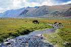
Now the important thing here is not the sheep we now know as the Marco Polo sheep, Ovis poli, but the fact that important areas of Inner Eurasia are ideally suited to pastoral nomadism. The nurturing landscape for the emergence of some of the great nomadic empires was often that of Mongolia and Manchuria, where the rolling hills provided ample pasturage and there was water from the melting snow. As modern studies have shown, the mix of natural vegetation in mountain pastures generally is more nutritious than domesticated animal fodder. It is no accident that when Han China began importing horses from Central Asia, it also imported the plants on which they fed. Vast as the extent of the mountain pastures and steppe lands may seem, it is also important to realize that their potential to support herds is not unlimited. Not all the vegetation is edible for domesticated animals, and the "carrying capacity" of pastures is limited. Thus, an unusually large group of horses (such as a nomadic army) might not be able to remain in one location for a long time, and for most nomads, seasonal movement was important - either horizontally or vertically - to ensure that there would always be adequate pasturage for the flocks which were essential for survival.
There is a common misperception that nomads had no fixed settlements and no agriculture. In fact, as recent archaeological evidence is abundantly demonstrating, pure nomadism was probably quite rare; mixed economies were the more likely. Most nomadic pastoralists followed regular patterns of movement from summer to winter camps; at the latter they often sowed crops to be harvested on their return in the autumn. One of the interesting questions which still needs to be answered regards the degree to which even small historic variations in climate in some of the traditional regions of nomadic pastoralism might have made possible more extensive agriculture than has been practiced in those same areas in more recent times.
The geography of the Silk Roads then is a complex interaction between the physical and climate zones of mountain, steppe or grasslands, and river valleys and oases which often are bounded by uninhabitable desert. Thus populations could be dispersed (in the grasslands) or concentrated in the oases and river valleys. Recent research is emphasizing the close interaction between pastoralists and agriculturalists in regions which incorporate a broad range of natural zones. While both sedentary and nomadic peoples adapted well to their natural environments, they were, nonetheless, especially vulnerable to disease and unexpected natural calamities.
Movement from one habitable location to another in pre-modern times would be possible only where water was to be found along the way and the barriers of physical geography presented no obstacles to travel on foot or on the backs of animals. From the modern perspective, where we are accustomed to the idea that one can travel almost anywhere at any time thanks to technology, the geographical limitations on travel in pre-modern times may seem formidable indeed. Raised as most of us have been in urban environments, it is hard for us to imagine people walking or riding hundreds or thousands of kilometers through areas largely devoid of human habitation, surviving on routes at the fringes of great deserts, or crossing mountain passes often higher than 5000 meters. Time and space were not numbered by our kind of reckoning. Navigation without the benefit of a map (or today a GPS unit) may be hard for us to imagine.
)
)
)
) Indeed, our early Silk Road travelers convey some sense of the challenges. Regarding the near vertical slopes of the Indus River gorge, Faxian writes:
Indeed, our early Silk Road travelers convey some sense of the challenges. Regarding the near vertical slopes of the Indus River gorge, Faxian writes:
The way was difficult and rugged, running along a bank exceedingly precipitous which rose up there, a hill-like wall of rock...When one approached the edge of it, his eyes became unsteady; and if he wished to go forward in the same direction, there was no place on which he could place his foot; and beneath were the waters of a river called the Indus. In former times men had chiseled paths along the rocks and distributed ladders on the face of them...at the bottom of which there was a suspension bridge of ropes ...
)
) By no means all of the routes followed precipitous paths carved out of sheer cliffs, for had travel been only on such routes, that would have limited severely the volume of trade. Many mountain passes, while difficult because of the altitude, are in fact quite easy to cross, providing one is not caught in an unexpected storm. Safe travel across steppe lands might be possible in almost any direction, providing one did not lose one's way and providing one had the protection of the nomads through whose lands one might pass.
By no means all of the routes followed precipitous paths carved out of sheer cliffs, for had travel been only on such routes, that would have limited severely the volume of trade. Many mountain passes, while difficult because of the altitude, are in fact quite easy to cross, providing one is not caught in an unexpected storm. Safe travel across steppe lands might be possible in almost any direction, providing one did not lose one's way and providing one had the protection of the nomads through whose lands one might pass.
)
)
)
)
) An example of one of the most important east-west routes is that which extends from the pasture lands of the Mongolian Altai Mountains through Xinjiang and on to today's Kazakhstan. The route parallels the northern slopes of the Tienshan Mountains, starting in a rich area of grasslands and agriculture in the vicinity of Lake Barkol, a region of strategic importance linked via a narrow mountain gorge to Hami in the south, one of the major outposts on the "northern Silk Road." In the period of T'ang Dynasty re-conquest of the Western Regions,
An example of one of the most important east-west routes is that which extends from the pasture lands of the Mongolian Altai Mountains through Xinjiang and on to today's Kazakhstan. The route parallels the northern slopes of the Tienshan Mountains, starting in a rich area of grasslands and agriculture in the vicinity of Lake Barkol, a region of strategic importance linked via a narrow mountain gorge to Hami in the south, one of the major outposts on the "northern Silk Road." In the period of T'ang Dynasty re-conquest of the Western Regions, ) a major military outpost was maintained at Da He, not far from Lake Barkol. The route continues west, flanking Bogdo Ula, the largest mountain massif of the eastern Tienshan, whose glaciers feed the streams which make irrigated agriculture possible. Another of the important military and administrative centers from the T'ang period down to the end of the Mongol Yuan Dynasty was at Beiting, east of the modern capital of the Uighur Autonomous Region, Urumqi. A broad valley enters from the south just west of Bogdo Ula and connects the well-watered northern slopes of the mountains with the irrigation-dependent Turfan oasis in the south. Both sides of the Eastern Tienshan were important for the Uighur kingdom which flourished here between the 9th and 13th centuries.
a major military outpost was maintained at Da He, not far from Lake Barkol. The route continues west, flanking Bogdo Ula, the largest mountain massif of the eastern Tienshan, whose glaciers feed the streams which make irrigated agriculture possible. Another of the important military and administrative centers from the T'ang period down to the end of the Mongol Yuan Dynasty was at Beiting, east of the modern capital of the Uighur Autonomous Region, Urumqi. A broad valley enters from the south just west of Bogdo Ula and connects the well-watered northern slopes of the mountains with the irrigation-dependent Turfan oasis in the south. Both sides of the Eastern Tienshan were important for the Uighur kingdom which flourished here between the 9th and 13th centuries.
)
)
) As the route continues west, it rises to a plateau occupied by beautiful Lake Sayram. Its surrounding pasture lands are still important for the herding families of the region; it was near here that Chingis Khan mustered his forces on his way to conquer Central Asia. Beyond Sayram, the route drops down through a winding mountain gorge into the Ili River valley, a region of historic importance from well back in the Bronze Age. The valley is rich with tombs of the nomadic Wusun, to whom the Han Dynasty had sent envoys in the 2nd century BCE; recent excavations have unearthed important burials connected with the Türk Empire. The Chaghatayid branch of the Mongol Empire had its capital here. The Ili Valley provides an unobstructed passage into the steppes of Kazakhstan. Even in the 19th and 20th centuries, the economic resources of the Ili region and its strategic importance as a communications highway made it a focal point of international politics in Inner Asia.
As the route continues west, it rises to a plateau occupied by beautiful Lake Sayram. Its surrounding pasture lands are still important for the herding families of the region; it was near here that Chingis Khan mustered his forces on his way to conquer Central Asia. Beyond Sayram, the route drops down through a winding mountain gorge into the Ili River valley, a region of historic importance from well back in the Bronze Age. The valley is rich with tombs of the nomadic Wusun, to whom the Han Dynasty had sent envoys in the 2nd century BCE; recent excavations have unearthed important burials connected with the Türk Empire. The Chaghatayid branch of the Mongol Empire had its capital here. The Ili Valley provides an unobstructed passage into the steppes of Kazakhstan. Even in the 19th and 20th centuries, the economic resources of the Ili region and its strategic importance as a communications highway made it a focal point of international politics in Inner Asia.
)
)
)
)
)
)
)
As this example has shown, of itself the geography of Inner Asia was not always the most important obstacle to travel and exchange in pre-modern times. More important would be the political landscape. Key points could be fortified and control communications - places where valleys between steep mountains narrowed or where the only route connecting wells or other sources of water might pass. The most famous of such points were the "Jade Gates" located at various moments in the history of the Silk Roads either at the edge of the desert in what is now Western China or in the narrow Hexi corridor, where mountain and desert constrict the normal route of passage. These these "gates" - physical fortresses - were parts of the Great Wall system, whose remnants today may be seen in many places along both the northern and southern routes of the Silk Roads in western Gansu and Xinjiang.
To emphasize only the difficulties of travel and communication as seen from the modern perspective seriously underestimates the capacity of pre-modern people to adapt to their environment. They acquired or hired the expertise to be able to travel safely in difficult conditions. Travel might extend over long periods of time, broken by intervals where weather or local political conditions dictated that one stop. Most travelers covered only a portion of the "Silk Road" - those like Xuanzang or Marco Polo who went thousands of kilometers were the exception. Just as governments and local communities could control passage, they could also facilitate it by building bridges or caravan sarais, installing garrisons, or erecting markers to define a route though otherwise featureless terrain. To a considerable degree, habitation and the flow of communication on the Silk Roads depended on ephemeral conditions of war or peace. The same Mongols who might in one area destroy irrigation systems and thus render certain areas uninhabitable would in a different region extend irrigation as a means of promoting economic prosperity. Even the period when the Mongol Empire had largely disintegrated, the Italian merchant Pegolotti observed that travel all across Asia to China was safe, except in periods of civil war. There is a persuasive argument that the apparent decline of the overland trade in Inner Asia in the 15th and 16th centuries was less a consequence of the opening up of sea routes connecting East Asia with Europe and more a consequence of political instability which made the cost of safe overland travel prohibitive.
Climate change and its consequences
Our current concerns over global warming remind us that any examination of human history over a period of millennia (and also much shorter periods) must take into account climate change. As the authors of an important recent study relating the flourishing of the Scythians in Eurasia to climate change have pointed out, "Prehistoric communities living in marginal areas of food production may react in a very sensitive way to environmental changes, because such changes can have an enormous impact on their way of life and even survival." If we are wanting to understand movements of peoples, the rise and fall of polities, it may well be the explanations lie in the climate.
)
)
)
)
Before we turn to longer-term trends in pre-history, we might look at one short-term modern example. In Mongolia even today a substantial percentage of the population still relies on herding for their livelihood. Understandably then, livestock mortality is a critical concern. A recent study has demonstrated that the critical factor which can substantially increase livestock mortality in any given year is a dzud, that is, a particularly bad winter which may consist of heavy snow or melting and freezing to create such a hard crust of ice that the animals cannot break through it to get at the dried grass underneath. The fodder herders store at their winter camps is largely an emergency supply and by itself insufficient to supply all the needs of the flocks until the next summer grazing season. There were successive winters of dzud in 2000-2002; in general one can expect such conditions to recur every two to three years. Now, in these circumstances, it is easy to see how prosperous herders could, almost overnight, become desperate. It is entirely possible then that they might be compelled to move to other areas in order to find more favorable conditions for their herds and to recover; or, in a pre-modern situation, they might find themselves submitting to the control of other groups, within which they would be able to survive. Just such a disaster of a single severe winter in 626-627 CE helped bring down the powerful Eastern Türk state, and in similar fashion in the middle of the 9th century, the abrupt collapse of the Uighur state in Mongolia was due in part to an unusually severe winter.
Climate change over large areas of Eurasia seems to have encouraged major population movements in conjunction with fundamental changes in the ways of life of those involved. Of particular interest for what some term the pre-history of the Silk Roads was a signficant warming which occurred across much of Eurasia around 850 BCE. Studies of lake sediments in the Enisei River basin in Siberia (just to the west of Lake Baikal) have shown that the combination of rising temperatures and precipitation led to significant changes in vegetation. Areas that had formerly been too cold or desert-like now could support grazing and some agriculture. Conditions developed which favored the expansion of herding and the development of nomadic pastoralism in areas where it previously had not existed. The earliest known royal tombs of the Scythian nomads have been found precisely in this remote northern region and date to a period soon after these favorable changes in climate. There is a reasonable hypothesis that the spread of mounted nomadism across Eurasia and thus the wide range of "Scythian" culture from the region of the Black Sea to Mongolia (and possibly beyond) may be explained by climate change. The more favorable economic conditions coincided with an increase in population; this in turn put pressure on the natural resources to the extent that out-migration became necessary. The period of favorable climate conditions for nomads in southern Siberia continued for several centuries, as the rich burials in the Tuvan region of the Altai Mountains attest. Thus, well before the traditional date of the "beginning of the Silk Roads" (the 2nd and 1st centuries BCE), conditions favored long-range exchange connecting the homeland of the Altai nomads with both the Middle East and with China.
) It seems possible that there is a connection between climate change and the developing interaction in the late 3rd century BCE between the nomadic Xiongnu and China, normally seen as the stimulus for the opening of the silk roads. While much of the area of what is now southern Mongolia and Inner Mongolia today is arid, the boundary between desert and loess soil suitable for grazing or agriculture has fluctuated over the millennia. The rise of the Xiongnu seems to correlate with a period when desertification was less than its historic maximum; thus the region north of and within the bend of the Yellow River was suitable for the kind of mixed economy which we think the Xiongnu practiced. There is an impressive concentration of archaeological evidence about human settlement in this region in the last centuries before the common era. It was likely that the populations and economic resources were sufficient to encourage Chinese expansion to the north, which put them on a collision course with the nomads. As Nicola Di Cosmo has argued, it was not so much to keep the nomads out of China but rather to control the non-Chinese in these northern territories that the first sections of the Great Wall were built. By virtue of encouraging settlement in these somewhat marginal lands which could not support large numbers of people, the Chinese then may have created a situation where the capacity of the environment to support human activity was exceeded. Thus a reversal of the favorable natural conditions was accelerated, and a competition for scarce resources resulted. It is generally recognized that even in pre-modern times, the human impact on the environment could have very negative consequences.
It seems possible that there is a connection between climate change and the developing interaction in the late 3rd century BCE between the nomadic Xiongnu and China, normally seen as the stimulus for the opening of the silk roads. While much of the area of what is now southern Mongolia and Inner Mongolia today is arid, the boundary between desert and loess soil suitable for grazing or agriculture has fluctuated over the millennia. The rise of the Xiongnu seems to correlate with a period when desertification was less than its historic maximum; thus the region north of and within the bend of the Yellow River was suitable for the kind of mixed economy which we think the Xiongnu practiced. There is an impressive concentration of archaeological evidence about human settlement in this region in the last centuries before the common era. It was likely that the populations and economic resources were sufficient to encourage Chinese expansion to the north, which put them on a collision course with the nomads. As Nicola Di Cosmo has argued, it was not so much to keep the nomads out of China but rather to control the non-Chinese in these northern territories that the first sections of the Great Wall were built. By virtue of encouraging settlement in these somewhat marginal lands which could not support large numbers of people, the Chinese then may have created a situation where the capacity of the environment to support human activity was exceeded. Thus a reversal of the favorable natural conditions was accelerated, and a competition for scarce resources resulted. It is generally recognized that even in pre-modern times, the human impact on the environment could have very negative consequences.
) For a final example of climate change of particular importance to the history of the Silk Roads, we go to the Tarim Basin - that is the large area bounded by the Tienshan, Pamir and Kunlun Mountains, where the major river, the Tarim, is located just south of the Tienshan. The Taklamakan Desert dominates the Tarim Basin, but all along its edges the snowmelt from the mountains made possible flourishing agriculture in a chain of oases through which ran the historic trade routes.
For a final example of climate change of particular importance to the history of the Silk Roads, we go to the Tarim Basin - that is the large area bounded by the Tienshan, Pamir and Kunlun Mountains, where the major river, the Tarim, is located just south of the Tienshan. The Taklamakan Desert dominates the Tarim Basin, but all along its edges the snowmelt from the mountains made possible flourishing agriculture in a chain of oases through which ran the historic trade routes.
The late 19th and early 20th-century explorers and archaeologists who documented the historic silk roads in the Tarim Basin encountered abandoned cities way out in the desert. Their remains suggested that they once had been supported by intensive agriculture and that they had extensive international trading connections. Documents found at some of the sites along the "southern Silk Road" suggested that they had flourished into the 4th century, but then declined sharply. By the time the famous traveler-monk Xuanzang passed through the region in the 7th century, some of the important towns had already been abandoned.
)
)
)
Of particular interest in this history is the fate of Loulan, a town located on the shore of Lake Lop Nor, into which flowed a branch of the Tarim River. Loulan was a key outpost along the Silk Roads until about the fourth century; as other archaeological remains have demonstrated, the region in which it is located must for a long time have been well watered and suitable for settlement. At the time the famous Swedish explorer Sven Hedin visited the region at the end of the 19th century, the Tarim River no longer flowed into Lop Nor, and all that remained of the lake was a shallow, dry depression. Hedin became convinced that this dessication was a cyclical phenomenon, and his prediction that eventually the lake would re-fill came true in the early 1920s. He attributed the changes to wind erosion, whereby the shallow rivers and lakes would fill with wind-blown sand and thus change their course. That Lop Nor today is again but a dry depression is due to the fact that all the Tarim's water upstream is being used for irrigation.
Recent studies based on a range of data gathered around the Tarim Basin (notably, the evidence of glacial cores concerning levels of precipitation) have solidified our understanding of the processes which led to the earlier drying up of Lop Nor and some of the rivers which had supported the oasis settlements of the southern Tarim. The first centuries CE witnessed a rise in temperatures and precipitation, creating the favorable conditions in which the towns of the southern Silk Road could flourish. But then beginning around the end of the third century, the climate shifted to one of lower temperatures and less moisture. While work is still needed to see whether the correlations can be made more precise, this shift seems to have precipitated the demise of cities such as Loulan and Niya.
There is still much to learn about the history of climate change. It remains to be seen whether a sufficiently large and chronologically precise database of regional variations can be compiled which might help explain specific historic events. For example, one of the questions which repeatedly has been raised concerns the reason for the rise and rapid expansion of the Mongol Empire. Some have posited the explanation might lie in climate change, but so far convincing evidence is lacking. Unless explicitly documented in a reliable written source, the kind of short-term disaster such as a dzud - the harsh winter which kills large numbers of flocks - generally cannot yet be pinpointed by historic climate records from scientific data. Data from Mongolia are still needed if we are to prove a longer term cooling or dry period coinciding with the rise of Chingis Khan, even if it seems clear that the 1220s, after the initial major expansion, included a period of significant cooling across Eurasia which might have weakened opposition to the Mongols. Even when we can document some natural disaster, how to interpret its consequences may be a matter for dispute. A nomadic group whose herds have been decimated by unusually severe climate conditions is hardly likely to be strong enough to set out on a campaign of conquest. And, if one region suffered, can we be sure that those living in a neighboring region escaped the same fate?
It may well be that for a question such as the reasons for Mongol expansion, we need look in the first instance at human factors: the quality of leadership, political and social organization, superior military skills, the accumulation of wealth from sources other than the nomads' herds, and so on. As Joseph Fletcher has emphasized, these factors may well be related to the features of steppe ecology where distinctive patterns of social and political organization emerged in response to the exigencies imposed by the natural environment.
)
Conclusion
Any attempt to understand the history of the Silk Roads must take into account the geography of Eurasia. As Ferdinand von Richthofen, the pioneering German geographer who coined the phrase "the silk roads" in the 19th century emphasized, physical and human geography are inseparable. While he began his monumental study of China with an examination of the physical landscape and the natural processes which shaped it, he always felt that the human history of exchange and the relationship between man and his environment was what made a region such as the Tarim Basin so important.
This essay has sketched some, but by no means all of the geographic factors relevant to Silk Road history. There is still much which might be said about specific natural resources and regions only touched on above. The emphasis here has been on physical geography, rather than human, but to do justice to the latter requires separate treatment. Western Eurasia is certainly part of the larger picture even if it has figured little in this discussion. The generic considerations about mountains, water, oases and routes of communication based on Central and East Asian material are equally valid in dealing with the West. However, as the new research of scholars such as Sebastian Stride suggests, we should move beyond higher levels of generalization concerning large regions. Important new understandings of the relationship between geography and human history may emerge from careful studies of regional geographies of smaller areas within the somewhat ill-defined territories of the large political entities which have to date attracted the most attention.
Daniel C. Waugh
The University of Washington (Seattle)
References
William S. Atwell, "Volcanism and Short-Term Climatic Change in East Asian and World History, c. 1200-1699," Journal of World History 12/1 (2001): 29-98. Summarizes (esp. pp. 42-45) evidence suggesting that cold and bad weather in the mid- to late 1220s across northern Eurasia may well have weakened opposition to Mongol expansion.
Samuel Beal, tr. Si-yu-ki. Buddhist Records of the Western World. Translated from the Chinese of Hiuen Tsiang (A.D. 629), 2 v. (London: Trübner, 1884; also reprinted). The account of Xuanzang's journey, not necessarily from his pen, but with abundant eye-witness detail. Beal's translation has been superseded by Li Rongxi's less easily available 1996 translation. Selections from Beal covering the journey up to the arrival in India are on-line.
Samuel Beal, tr. Travels of Fah-Hian and Sung-yun, Buddhist Pilgrims from China to India (400 A.D. and 518 A.D.) (London: Trübner, 1869). The Faxian text is the more important one. The parts of it covering his journey prior to when he reaches India are on-line.
S. Begsuren et al. "Livestock responses to droughts and severe winter weather in the Gobi Three Beauty National Park, Mongolia," Journal of Arid Environments 59 (2004): 785-796. Analysis of impact of dzud and drought on livestock mortality.
Yuri Bregel, An Historical Atlas of Central Asia (Leiden; Boston: Brill, 2003).
Claudia Chang et al. "Iron Age society and chronology in South-east Kazakhstan," Antiquity 77, No. 296 (June 2003): 298-312.
David Christian, "Silk Roads or Steppe Roads? The Silk Roads in World History," Journal of World History 11/1 (2000): 1-26. Argument for talking about "steppe roads," not "silk roads."
Christopher Dawson, ed., The Mongol Mission (various editions, also titled Mission to Asia), includes account by John of Plano Carpini. Another version of Carpini is available on-line.
Nicola Di Cosmo, "Ancient Inner Asian Nomads: Their Economic Basis and Its Significance in Chinese History," The Journal of Asian Studies 53/4 (1994): 1092-1126. Important article, emphasizing that Inner Asian nomadism was not "pure," that is, that it should be seen as a mixed economy with an agricultural component.
Nicola Di Cosmo, "The Origins of the Great Wall," The Silk Road 4/1 (2006): 14-19. A well argued re-evaluation of the traditional narratives about the origin and purpose of the Great Wall. Also on-line.
V. G. Dirksen et al., "Chronology of Holocene climate and vegetation changes and their connection to cultural dynamics in southern Siberia," Radiocarbon 49/2 (2007): 1103-1121. Based on sediment samples in two lakes in upper Enisei basin; establishes plausible connection with changes in the archaeological cultures in the region.
Die Erde. Zeitschrift der Gesellschaft für Erdkunde zu Berlin 138/4 (2007). A special issue devoted to Ferdinand von Richthofen.
Joseph Fletcher, "The Mongols: Ecological and Social Perspectives," Harvard Journal of Asiatic Studies 46/1 (1986): 11-50. Connects nomadic "steppe ecology" with Mongol expansion, and the adoption of the contrasting "desert pattern" of exploiting economic resources with the political disintegration of the empire.
B. van Geel et al., "Climate change and the expansion of the Scythian culture after 850 BC: a hypothesis," Journal of Archaeological Science 31 (2004): 1735-1742. Far-reaching hypothesis regarding significance of climate change across Eurasia in mid-9th century BCE. Critique and authors' response are in 33 (2006): 143-144; 145-148.
B. K. Hanks et al. "Towards a refined chronology for the Bronze Age of the southern Urals, Russia," Antiquity 81, No. 312 (June 2007): 353-367. Valuable step in the direction of establishing an absolute chronology, which may help solve some of questions about relationships of archaeological cultures in this important area of interaction.
Sven Hedin, The Wandering Lake (New York: Dutton, 1940), translation of the Swedish Den vandrande sjön (Stockholm: Bonniers, 1937). His discoveries about Lop Nor.
Gareth Jenkins, "A Note on Climatic Cycles and the Rise of Cinggis Khan," Central Asiatic Journal 18/4 (1974): 217-226. Speculates on possible climate impact on the emergence of the Mongol Empire, arguing that a long period of cooling in the 12th and 13th centuries adversely affected natural resources in Mongolia.
Owen Lattimore, Inner Asian Frontiers of China (Boston: Beacon Press, 1940; 1951). A classic account which interweaves astute observations on geography with now dated generalizations about peoples and their historic tendencies.
Owen Lattimore, Studies in Frontier History: Collected Papers 1928-1958 (London, etc.: Oxford University Press, 1962). Informed by the author's own travels and his excellent sense of the relationship between geography and history.
Guy Le Strange, The Lands of the Eastern Caliphate. Mesopotamia, Persia, and Central Asia, from the Moslem Conquest to the Time of Timur (Cambridge: Cambridge Univ. Pr., 1905). Historical geography of the Middle East.
Pierre Leriche, "Bactria, Land of a Thousand Cities," in Joe Cribb and Georgina Herrmann, eds., After Alexander: Central Asia before Islam. Proceedings of the British Academy 133 (Oxford and New York: Oxford University Press, 2007): 121-153. Reassessement of what we know from archaeology about urban settlement in Bactria before, during, and after the period of Greek occupation, the Greek contribution to urbanization turning out to be substantially less than what the ancient Greek sources suggest.
E. M. Murzaev, Mongol'skaia narodnaia respublika. Fiziko-geograficheskoe opisanie (The Mongolian People's Republic. A Physical Geographic Description), 2nd rev. ed. (Moscow: Gos. izd-vo. geograficheskoi literatury, 1952).
Jason Neelis, "La Vieille Route Reconsidered: Alternative Paths for Early Transmission of Buddhism Beyond the Borderlands of South Asia," Bulletin of the Asia Institute 16 (2002 [2006]): 143-164. An excellent reassessment of traditional views regarding the routes of transmission of Buddhism to the north.
Francis Balducci Pegolotti, "Notices of the Land Route to Cathay and of Asiatic Trade in the First Half of the Fourteenth Century," in Henry Yule and Henri Cordier, eds., Cathay and the Way Thither: Being a Collection of Medieval Notices of China, vol. III (London: Hakluyt Society, 1916), pp. 137-173.
Marco Polo, The Travels, tr. R. Latham (Harmondsworth: Penguin, 1958).
Arlene Miller Rosen et al. "Paleaeoenvironments and economy of Iron Age Saka-Wusun agro-pastoralists in southeastern Kazakhstan," Antiquity 74 (2000): 611-623.
Denis Sinor, "Horse and Pasture in Inner Asian History," Oriens Extremus 19/1-2 (1972): 171-183; reprinted in idem, Inner Asia and its Contacts with Medieval Europe (London: Variorum, 1977). Valuable for comments on steppe ecology.
John Masson Smith, Jr., "Mongol Nomadism and Middle Eastern Geography: Qishlaqs and Tümens," in Reuven Amitai-Preiss and David O. Morgan, eds., The Mongol Empire and its Legacy (Leiden etc.: Brill, [1999]): 39-56. An effort to correlate historical data on size and movement of Mongol armies with the realities of what pastureland could support.
Sebastian Stride, "Regions and Territories in Southern Central Asia: What the Surkhan Darya Province tells us about Bactria," in Joe Cribb and Georgina Herrmann, eds., After Alexander: Central Asia before Islam. Proceedings of the British Academy 133 (Oxford and New York: Oxford University Press, 2007): 98-117. Important for conceptual re-framing of questions concerning the relationship between geography and historical settlement and political patterns in Central Asia. Argues for the importance of studying distinct smaller regions within larger polities.
Sredniaia Aziia. Fiziko-geograficheskaia kharakteristika (Central Asia. Physical Geographic Characteristics) (Moscow: Izd-vo Akademii nauk SSSR, 1958).
Robert N. Taafe, "The Geographic Setting," Ch. 2 in Denis Sinor, ed., The Cambridge History of Early Inner Asia (Cambridge: Cambridge Univ. Pr., 1990): 19-40.
Daniel C. Waugh, "Richthofen's 'Silk Roads': Toward the Archaeology of a Concept," The Silk Road 5/1 (2007): 1-10. Also on-line.
Yang Bao et al. "Evidence for a late Holocene warm and humid climate period and environmental characteristics in the arid zones of northwest China during 2.2 ~ 1.8 kyr B.P.," Journal of Geophysical Research 109 (2004), DO2105. Important study indicating period between ca. 200 BCE and 270 CE, especially from ca. 30-270 CE, was one of higher temperature and precipitation than normal in NW China (Xinjiang, NW part of Tibet, W part of Gansu). This coincides with expansion and flourishing of Han era settlements. With drop in temperatures, followed soon after by drop in precipitation, important settlements such as those at Loulan, Niya, and Keriya went into decline and disappeared.
Yang Bao et al. "General characteristics of temperature variation in China during the last two millennia," Geophysical Research Letters 29/9 (2002), 1324, 10.1029/2001GL014485. Composite of data determining chronology of warm and cold periods: 0-240 CE warm, 240-800 CE cold, 800-1400 CE warm (esp. 800-1100), 1400-1920 cool, 1920-present warm. Medieval warm periods show regional variation; cool periods more uniform. Data for China correlate well with that for whole of northern hemisphere.
G. I. Zaitseva et al., "Chronology and possible links between climatic and cultural change during the first millennium BC in southern Siberia and Central Asia," Radiocarbon 46/1 (2004): 259-276. Argument that "most representative" Scythian culture started in Uyuk and Minusinsk valleys as a consequence of climate change in 9th century.
G. I. Zaitseva et al. "Chronology of key barrows belonging to different stages of the Scythian period in Tuva (Arzhan-1 and Arzhan-2 barrows)," Radiocarbon 49/2 (2007): 645-658. Good summary of rather precise dating of these two important tombs.
W. J. Zhou et al., "Environmental variability within the Chinese desert-loess transition zone over the last 20,000 years," The Holocene 12/1 (2002): 107-112. Data concerning the shifting desert/loess boundary in the north China region extending eastwards through the bend of the Yellow River. Connects southerly shift of desert with environmental damage due to human activity starting in ca. 2000 BCE, but accelerating due to Han and subsequent settlement of steppe zone.
Copyright © Daniel C. Waugh 2008
Written for "Silk Road Seattle" and last revised August 15, 2008, the revision being a substantial expansion and rewriting of the essay previously posted under the same title. Photographs and drawings are copyright by the author, except as credited in captions.
Photo galleries here are intended to provide a sense of Silk Road geography in various countries. We hope eventually to add images from other regions and write separate essays using this visual material as illustrations. The photographs are provided courtesy of several photographers, who reserve their respective copyrights. Unless otherwise indicated, photographs are by Daniel C. Waugh.