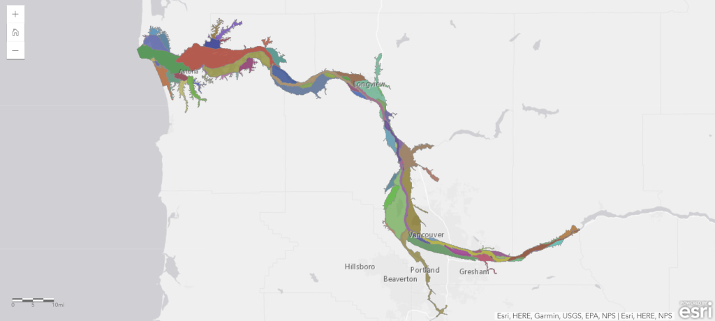
Definition of Fish Habitat Catenae

A fish habitat catena is a unique set of landscape features that describes geomorphic and other characteristics of beneficial habitat for juvenile salmon. Fish habitat catenae have been defined by the project team based on current scientific understanding of how juvenile salmon use estuarine habitats. We selected aquatic geomorphic catenae from the Classification that are believed to be beneficial to juvenile salmon, such as primary, secondary, and tributary channel shallows (intermittently exposed), floodplain and tidal channels, and floodplain lakes.
We delineated open fish habitat catena that juvenile salmon can directly occupy, as well as altered fish habitat catena where natural tidal-fluvial flooding is regulated or isolated and thus have potential for future restoration or enhancement.
Indirect Fish Habitat & Landscape Features
 In addition to direct fish habitat catenae, we identify specific indirect fish habitat (adjacent wetlands, tidal drainage, and 2-year flood extent) and landscape features (channel confluences, tributary channel head of tide, and potential beaver habitat). Herbaceous, scrub-shrub, and forested wetlands mediate the quality of the habitat which juvenile salmon occupy when migrating through or rearing in the estuary. Included in the geodatabase are wetlands adjacent to the aquatic features selected as direct juvenile salmon habitat. Adjacency to the channel or lake feature is defined differently by the wetland type: within 2 meters for herbaceous vegetation, within 5 meters for scrub-shrub vegetation, and within 20 meters for coniferous and deciduous forest.
The drainage area of fish habitat catena, derived from the 2010 land cover hydrologic information prepared by the Lower Columbia Estuary Partnership, applies to the surge plain and floodplain below Mean Higher High Water and provides an estimate of tidally influenced areas and areas cutoff from tide. The 2-year flood extent is derived from the 2011 modeled 50% exceedance values from the Army Corps of Engineers, and provides an estimate of the area inundated under the 2-year flood elevation or Extreme Higher High Water (mean highest monthly tide), whichever is higher.
The landscape features we identify are discrete attributes, such as channel confluences and the head of tide in tributaries to the estuary, that represent important transition and access points for fish as well as provide information on habitat complexity and opportunity. We are also developing GIS rules to identify potential locations of American beaver (Castor canadensis) habitat, which is known to benefit juvenile salmon in tidal wetlands and is expanding throughout the former range of this “ecosystem engineer”.
Hierarchical Structure of the Landscape Planning Framework

Schematic diagram illustrating the hierarchical structure of the Landscape Planning Framework classification of fish habitat catenae (blue) and indirect fish habitat under major Ecosystem Complexes.

Database Structure
 Direct and indirect fish habitats are assembled into a geodatabase that can be analyzed, both for statistical summarization of juvenile salmon habitats in the estuary, and for designing strategic restoration and protection scenarios. The LPF can be applied at multiple spatial scales, from the reach or landscape level to a user defined individual site level. The geodatabase maps direct fish habitat (aquatic features that juvenile salmon may directly occupy), and three levels of indirect fish habitat: adjacent wetlands, tidal drainage, and USACE 2-year flood extent. The database also identifies three types of landscape features: channel confluences, potential locations of American beaver (Castor Canadensis) habitat, and the head of tide in large tributaries to the estuary.
Open fish habitat is identified as direct habitat, and the associated indirect habitat, that juvenile salmon can access without obstruction; altered fish habitat is identified where natural tidal-fluvial flooding is regulated or isolated and thus has potential for future restoration or enhancement.
The LPF Fish Habitat Catena geodatabase and metadata (150 MB) has been made available for public download through the University of Washington: Geodatabase Download
Data Summaries
 The Direct and Indirect fish habitat catena are assembled into a GIS geodatabase that can be analyzed, both for statistical summarization of juvenile salmon habitats in the estuary, and for designing strategic restoration and protection scenarios.
Data summaries and preliminary analysis demonstrate the relative gain in the accessibility and capacity of fish habitat catenae that would accrue with restoring tidal-fluvial flooding to the currently altered catenae among the eight hydrogeomorphic reaches in the Columbia River estuary.