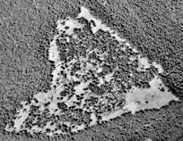
| Using
GIS (change detection) analyses of historical aerial photographs,
Janine Rice (a doctoral graduate of Oregon State University) quantified
rates and environmental correlates of meadow loss at Bunchgrass
Ridge between 1946 and 2000 (photo sequence, right).
Her
research addressed the following questions:
- At
what rate have meadows been lost at Bunchgrass Ridge
since the mid-1900s?
-
What proportion of the study area remains open?
- Do
rates of loss vary with proximity to edge, aspect, or slope?
Meadow
area declined dramatically—by 60%—between 1946 and
2000.
Losses were greater
- within
5 m of the forest edge
- on
west- and south-facing aspects
- on
flatter terrain
Meadow
loss occurred more rapidly between 1946 and 1967, than in subsequent
decades.
| Rice,
J. M., C. B. Halpern, J. A. Antos, and J. A. Jones. 2012. Spatio-temporal patterns of tree establishment are indicative of
biotic interactions during early invasion of a montane meadow. Plant
Ecology 213:555-568. Request reprint |
|
| Changes
in the forest-meadow mosaic |
| 1946 |
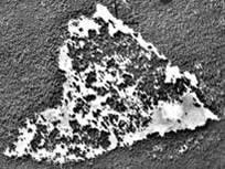 |
| 1967 |
 |
| 2000 |
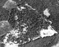 |
| Clearcuts
are apparent in the 2000 photo. |
|
|
|
_13%20Ju%202009_sm.jpg)