For historical interest, the table of calibration sites proposed for the CRONUS project in 2003 is shown below.
| Site |
Advocate(s) |
Latitude
(geographic)
|
Altitude (m) |
Geological / geomorphological context. What type of surfaces will be sampled? |
Rock types?
Nuclides?
|
Age - What independent age control exists? |
Comments on cover since formation (snow/soil/ash/water/etc) |
Comments on erosion since formation |
Comments on prior exposure and/or inheritance |
Comments on stability of surfaces |
Accessibility |
Availability of material at the site |
Experts on the geology / geomorphology / history of the site |
Relevant publications |
Photos or maps |
Other comments |
|
Lake Bonneville shorelines
|
Nat Lifton
|
39-41N
|
1540 m (Bonneville)
1440 m (Provo)
|
Shorelines cut into bedrock during stillstands of glacial Lake Bonneville (Oviatt et al., 1992). Shorelines are cut back deeply into hillsides, and must have involved tens of meters of erosion.
|
Quartzite, acid volcanics, basalt (Tabernacle Hill) Paleozoic limestone, Tufa.
Be-10, Al-26, C-14 in quartz ; Cl-36 in quartz; Cl-36 in calcite; Ne-21 in quartz; Cl-36 in pyroxene, and Ca-feldspar. He-3 and Ne-21 in olivine and pyroxene.
others ...
|
The chronology of the late Pleistocene lake cycle is constrained by 83 radiocarbon ages and is considered one of the most reliable in the world (Benson et al., 1990; Oviatt et al., 1992). The most reliable radiocarbon dates on the age and duration of the Bonneville level are 5 charcoal samples, which yielded a date of 15,250 ± 160 14C yr B.P. (Beta-23174, Oviatt et al., 1992), providing a maximum age for cutting of the shoreline. This shoreline was abandoned after catastrophic failure of the lake threshold at Red Rock Pass in southern Idaho dropped the lake level approximately 100 m to the Provo level. Dense tufa collected from the edge of the Tabernacle Hill basalt flow, erupted into the Provo-level lake, yielded the most reliable age obtained directly from the Provo shoreline—14,320 ± 90 14C yr B.P. (Beta-23803, Oviatt et al., 1992). Thus, the age of the flood event is constrained between 15.25 ± 0.16 14C ka and 14.32 ± 0.09 14C ka, but is generally thought to be 14.5 14C ka (Oviatt et al., 1992). Oviatt and Nash (1989) place the eruption age (essentially equal to the exposure age) of the Tabernacle Hill flow between 14.5 14C ka and 14.3 14C ka. Lifton et al. (2001) thus adopted the 14.5 14C ka age as the exposure age of the Bonneville shoreline, and 14.4 14C ka as the exposure age of the Tabernacle Hill basalt flow. The age of abandonment of the Provo level is best constrained by a single date on mollusks deposited below the shoreline of 13,900 ± 400 14C yr B.P. (W-899, Oviatt et al., 1992), and Lifton et al. (2001) adopted an age of 14.0 14C ka for abandonment.
|
Possible ash cover of Tabernacle Hill flow.
Other surfaces - possibility of cover is negligible or easily avoided.
|
Primary wave rounding and polishing is still present in quartzite outcrops on Provo and Bonneville shorelines, demonstrating negligible erosion since their formation.
|
Shorelines are all deeply cut into hillsides, and must have involved tens of meters of erosion.
|
Stable
|
Some previously-sampled sites are on private land and access may be restricted. Many similar sites in the Bonneville Basin with good potential have not yet been visited.
|
Unlimited
|
|
Lifton et al. (2001) A new extraction technique and production rate estimate for in situ cosmogenic C-14 in quartz. Geochim. Cosmochim. Acta 65, 1953-1965.
Oviatt C. G. (1997) Geology 25(2), 155-158.
Oviatt C. G.et al. (1992) Palaeogeography, Palaeoclimatology, Palaeoecology 99, 225-241.
Oviatt C. G. and Nash W. P. (1989) Geol. Soc Am. Bull. 101(2), 292-303.
Handwerger et al. (1999) Cosmogenic C-14 in carbonate rocks Geomorphology 27, 13-24.
|
|
Tabernacle Hill site has been used for calibration of He-3 and Ne-21 in olivine and pyroxene, and for Cl-36 in whole-rocks and Ca-feldspar. Quartzites at other sitesin the basin have been used for calibration of in-situ C-14 production in quartz and calcite. There is also one reported Be-10 measurement on a Bonneville shoreline quartzite. |
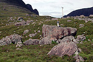
| Younger Dryas glacial landforms, Isle of Skye, Scotland |
Marc Caffee Lewis Owen Gary Landis Doug Benn
|
57.25 N
|
150 - 500 m
|
Moraines deposited during the Loch Lomond Readvance (LLR = Younger Dryas) glaciation. Glacially abraded bedrock surfaces exposed by retreat of LLR ice.
|
Granite, sandstone, basalt, gabbro; hence quartz, K-feldspar, plagioclase, pyroxene, (olivine) He-3, Be-10, C-14, Ne-21, Al-26, Cl-36
|
NW Scotland is very sensitive to changes in Northern Hemipshere/North Atlantic climate, and since the glaciers on Skye were small they would have responded rapidly (within a few decades) to climate change. Glacier fluctuations on Skye almost certainly were synchronous with variations in the 18O values in the Greenland ice sheet. We can, therefore, correlate individual moraine ridges to distinct 18O excursions in the Greenland ice-cores during the Younger Dryas Stade. In doing so, we can subdivide the Younger Dryas Stade from a simple 1300 year time span (11.6-12.9 ka) to centennial events during which distinct sets of moraines formed. Given that cirque glaciers have response times of decades, we can assume that the maximum extent of small glaciers on Skye dates to the coldest part of the Stade, when equilibrium-line altitudes (ELAs) were lowest. As such, the outer most moraine ridges would have likely formed at ~12.5+/-0.2 ka. Similarly the innermost moraines and ice-scoured bedrock surfaces near the heads of glaciated valleys should date to the timing of the final deglaciation at ca. 11.6+/-0.1 ka.
|
Negligible snow cover. Due to the maritime climate on Skye, snow does not persist for more than a few days a year, and it is unlikely that it was any more abundant during any time throughout the Holocene.
|
Brief exposure duration should ensure minimal erosion since deposition/exposure.
|
Inheritance of TCNs should not be a major problem because the British ice sheet should have eroded sufficient amounts of rock during the Devensian to minimize exposure inheritance.
|
Large boulders and bedrock stable since disappearance of glaciers.
|
Easily accessible. No restrictions on land access or scientific research.
|
Unlimited. Many large boulders and bedrock surfaces.
|
Lewis Owen
Doug Benn, University of St Andrews
|
Ballantyne, C.K. (1989) The Loch Lomond Readvance on the Isle of Skye, Scotland: glacier reconstruction and paleoclimatic implications. Journal of Quaternary Science, 4, 95-108.
Benn, D.I., Lowe, J.J. and Walker, M.J.C. (1992) Glacier response to climatic change during the Loch Lomond Stadial and early Flandrian: geomorphological and palynological evidence from the Isel of Skye, Scotland. Journal of Quaternary Science, 7, 125-144.
Brooks, S.J. and Birks, H.J.B. (2000) Chironomid-inferred Late-glacial air temperatures at Whitrig Bog, southeast Scotland. Journal of Quaternary Science, 15, 759-764.
Walker, M.J. and Lowe, J.J. (1990) Reconstructing the environmental history of the Last Glacial-Interglacial Transition: evidence from the Isle of Skye, Inner Hebrides, Scotland. Quaternary Science Reviews, 9, 15-49.
|
|
|
|
Maol Ceann Dearg and Applecross landslides, Scotland
|
John Stone Keith Fifield Jodie Evans Colin Ballantyne
|
57.5 N
|
485 m (Maol Ceann Dearg) 100-200 m (Applecross)
|
Landslides deposited large boulders onto Loch Lomond Readvance (LLR = Younger Dryas) glaciers. Boulders did not reach either glacier terminus, indicating deposition very shortly before the end of the LLR.
|
Torridon Sandstone (arkose: 80-90% quartz, 10-20% K-feldspar).
Be-10, Al-26, C-14 in quartz ; Cl-36 in quartz; Ne-21 in quartz; Cl-36 in K-feldspar.
|
There are no independent dates on these deposits. The end of the LLR in Scotland is constrained by C-14 dates, but like all C-14 dates for the YD, calibration is problematic and resulting dates are imprecise. Alternatively, the termination of the LLR can be assigned an age of 11,600 cal yr B.P. by correlation with the YD termination in Greenland ice cores. If it is assumed that this climate change occurred abruptly and synchronously around the N. Atlantic, the landslides would date to between (say) 11,700 and 11,600 B.P. Against this, it can be argued from biostrat records that the LLR terminated more gradually in Scotland than in Greenland. If so, the waning stage of glaciation associated with these deposits may have preceded the end of the ice-core YD by several centuries, placing the deposits at (say) 12,000 – 11,800 B.P.
|
No glacial/stadial exposure. Present snow-cover is a reasonable guide to possible shielding by snow during the Holocene exposure period. Present snow cover is ? days x ? cm at Applecross (close to sea level) and ? days x ? cm at Maol Ceann Dearg.
|
Less than a few centimeters. Slight rounding of boulder edges and flaring of joints.
|
One surface on any given boulder may have been exposed on a pre-existing cliff face prior to the slide. However, prior exposure problems unlikely to be important, given (i) improbability of sampling a pre-exposed face, (ii) original boulder orientations (prior to slide) can be used to guide sampling.
|
Many boulders >> 1m. Likely to have been stable since disappearance of transporting ice.
|
Both sites easily accessible. Road access, local accomodation, no known restrictions on sample collection.
|
Essentially unlimited. Many large boulder surfaces at both sites.
|
Colin Ballantyne, University of St Andrews
|
Glacial geology: Jones (1998) Scot. Geogr. Mag. 114, 164-171
LLR-Holocene transition: Brooks and Birks (2001) Quat Sci Rev 20, 1723-1741
|
|
Applecross site has been used for calibration of Cl-36 production from K (Jodie Evans' PhD thesis, ANU).
Trial samples from Meall Ceann Dearg 'dated' using Stone's preferred Be-10 production rate of 5.06 atom/g/yr give preliminary 'ages' of 12,020 +/- 450 yr, 12,070 +/- 450 yr and 11,540 +/- 380 yr.
|
|
Hawaiian basalt flows
|
Mark Kurz
|
|
|
|
|
|
|
|
|
|
|
|
|
|
|
|
|
Mt Mazama ejecta (Crater Lake, Oregon)
|
Seth Cowdery, Greg Balco, John Stone, Claire Todd
|
42.9 N
|
1800-2200 m
|
Granodiorite blocks ejected during the late stages of the climactic, caldera-collapse eruption of Mt. Mazama, now Crater Lake. Blocks are up to 4m in size and exhibit sharp corners, suggestive of minimal erosion (Bacon, 1992).
|
Granodiorite with minor quartz diorite, granite, aplite. Be-10, Al-26, Cl-36 in quartz; Cl-36 in feldspar.
|
Dated at 6845 +/- 50 radiocarbon years B.P. (7640 +40/-55 cal. yr B.P.; Bacon 1983). Large, climactic eruption of Mt. Mazama resulted in voluminous, widespread, and well-studied deposits. The geochemical and microparticle signature of the Mt Mazama ash appears in the GISP-2 ice core at 7627 years B.P., based on layer counting (Zdanowicz et al., 1999). The stated uncertainty in the layer counting at that point is +/- 150 years (+/- 2.0% in the age), but its remarkable correspondence to the calibrated radiocarbon date suggests that the actual uncertainty may be even less.
|
Possible cover by other pyroclastic debris, and significant snow cover during winter months. Further investigation/verification needed.
|
Sharp edges present on blocks suggest mininal erosion of the surfaces.
|
Blocks have been interpreted to have originated at 5 km depth within the crust (Bacon, 1992).
|
Landscape does not show evidence of significant erosion, reworking, or incision into volcanic landscape. Slopes are low-angle.
|
In Crater Lake National Park, hence permission/liaison with NPS would be required. Blocks have been sampled for petrologic studies in the past (Bacon, 1992).
|
Total number of blocks of suitable size and preservation is not yet known. Sampling will be limited by location in a national park.
|
Charles Bacon (USGS)
|
Bacon, C. R., 1992, Partially melted granodiorite and related rocks ejected from Crater Lake caldera, Oregon. In: GSA Special Paper 272, p. 27-47.
Bacon, C. R., 1983, Eruptive history of Mount Mazama and Crater Lake Caldera, Cascade Range, USA: Journal of Volcanology and Geothermal Research, v. 18, p. 57-115.
Zdanowicz, C.M., Zielinski, G.A. and Germani, M.S. (1999) Mount Mazama eruption: Calendrical age verified and atmospheric impact assessed. Geology 27(7), 623-626.
|
|
|
|
Late-glacial retreat deposits, northern New England
|
Greg Balco
|
43-45 N
|
0-100 m
|
Glacially transported erratics and glacially eroded surfaces in two geomorphic contexts. First, sites in coastal Maine and NH were deglaciated while below sea level and then were exposed by rapid sea-level fall between 17,000 - 14,000 cal yr BP. Second, sites above the marine limit were exposed by rapid deglaciation between 15,000-12,000 cal yr BP.
|
Glacially transported boulders are mostly Paleozoic granites. Glacially plucked rock outcrops are granite and metasediments.
All the usual nuclides formed in quartz and feldspars: Be-10, Al-26, C-14 in quartz; Cl-36 in quartz; Cl-36 in K-feldspar; possibly Ne-21 in quartz.
Still researching the possibility of finding mafic rock types.
|
The advantage of using the timing of relative sea-level fall as an independent exposure age is that sea level/radiocarbon age pairs can be confidently correlated across large areas based on the principle that the ocean is more or less horizontal. Thus a few dates from unambiguous stratigraphic settings can be confidently extended to give the exposure age of surfaces over a wide geographic area. This is better than relying on deglaciation ages, where it is difficult to directly connect radiocarbon-dated materials with the exposure of surfaces.
In the case of the Maine coastal lowland, the timing of RSL fall is known from three types of evidence, in order of reliability: 1) radiocarbon-dated molluscs and seaweed from intertidal sediment; 2) radiocarbon dates on the timing of isolation of lake basins by RSL fall, and 3) correlation between local RSL stillstands and periods of rapid global sea level rise (so-called meltwater pulses). For example, intertidal shell dates in the Casco Bay region (Weddle and Retelle, 2001), RSL dropped 40 m between 14,000 and 12,000 uncorrected C-14 yr B.P. The chief uncertainty in assigning calendar ages to this event is the size of the marine reservoir effect, which has been estimated by correlation of marine and adjacent terrestrial ice-marginal deposits as well as a few paired radiocarbon dates on adjacent shells and plant fossils to be 800-1200 yr. Thus, the timing of RSL fall in this region is known to an accuracy of ca. +/- 200-400 yr (3-4% uncertainty).
Dates on deglaciation of areas above the late-glacial marine limit are not subject to reservoir uncertainties. However, as noted above it is more difficult to directly connect a deglaciation age from lake sediments or organic material in ice-marginal sediments to the exposure age of a particular boulder or outcrop. In general, the timing of deglaciation in central New England (southern NH and SW Maine) is dated by: 1) radiocarbon dates on basal lake sediments; 2) the New England varve chronology of Ridge et al. (2001), which is based not only on varve correlation but also on direct radiocarbon dates on laminated sediments and by paleomagnetic inclination variations measured on the same sediment; and 3) radiocarbon dates on terrestrial organic material in ice-marginal deposits. The inaccuracy in deglaciation ages is minimized for the parts of this region that were deglaciated after 12,700 14C years B.P. (ca. 15,000 cal yr) because the ice margin retreated at 200-500 m/yr after this time. Thus, even if the ice marginal position associated with a certain radiocarbon date can only be confidently located to within 20 km, the geomorphic uncertainty only contributes an age uncertainty of <100 yr (~1%). The areas where the age of deglaciation is best known were generally deglaciated 16,000 - 14,000 cal yr BP.
|
In the case of large boulders and glacially plucked surfaces (most of which are on prominent steep slopes), the only likely cover is snow. At present average snow cover in this area amounts to < 1 m for 2-3 months/ yr. Careful selection of boulders and bedrock surfaces will be required to ensure minimal snow cover. However, direct observations can be used to determine which boulders carry the least snow.
|
Glacial polish preserved on stoss faces and often on boulders; spalling may have occurred on steep plucked faces.
|
Because there were no nunataks in this sector of the ice sheet, large boulders must have originated by plucking of upstream topography. The amount of sub-glacial erosion on such lee faces expected to be large based on the large number of boulders. Boulders that have been analysed around New England (Balco et al 2002, Bierman/Larsen/Clapp 1996) have tight age distributions suggesting low inheritance.
|
Stable surfaces (e.g. boulders on flat ground) widely available.
|
Wide variety of sites on private and public land available. Easy road access. Access generally unrestricted.
|
Unlimited
|
Chris Dorion, U. of Maine
Jack Ridge, Tufts Univ.
Tom Weddle, Maine Geological Survey
Mike Retelle, Bates College
Woody Thompson, Maine G.S.
Thom Davis, Bentley College
Greg Balco, U. of Washington
|
Weddle and Retelle (2001); Ridge (2001), Dorion et al. (2001), all in Weddle and Retelle, eds. Deglacial HIstory and Relative Sea-level Changes, Northern New England and adjacent Canada; Geol. Soc. Am. Special Publication 351 (2001).
Bierman et al. (1996) Refining estimates of 10Be and 26Al production rates. Santa Fe workshop on Cosmogenic Nuclides; Radiocarbon 38, 149.
Balco G. et al. (2002) Cosmogenic-nuclide ages for New England coastal moraines, Martha's Vineyard and Cape Cod, Massachusetts, USA. Quaternary Science Reviews, 21, 2127-2135.
|
|
|
|
Koefels landslide, Oetz Valley, Austria
|
J. Schaefer, Peter Kubik, Susan Ivy-Ochs, Hans-Arno Synal
|
47 N
|
1800 m
|
Largest landslide in the crystalline Alps (2.5 x 10^9 m^3). Landslide overran trees on valley ground. Large area; many boulders of many m^3 in size available for sampling.
|
Gneiss with quartz veins; no plagioclase; some K-feldspar.
Be-10, Al-26, C-14 in quartz; Cl-36 in quartz; Cl-36 in K-feldspar; Ne-21 in quartz (very tough!)
|
Reliable C-14 dating: Tunnel was drilled through landslide, wood from overrun trees dated. C-14 age: 8750 +/- 25 yrs C-14 yrs; calibrated age: 9800 +/- 100 cal yr.
|
Snow cover needs to be carefully assessed.
|
|
|
|
Accessible
|
Unlimited
|
|
Kubik, P.W., S. Ivy-Ochs, J. Masarik, M. Frank, and C. Schlüchter, 10Be and 26Al production rates deduced from an instantanenous event within the dendro-calibration curve, the landslide of Köfels, Ötz Valley, Austria, Earth and Planetary Science Letters, 161, 231-241, 1998.
|
|
(1) The Koefels Landslide has been selected as a primary calibration site for the CRONUS-EU project.
(2) The ETH group is intensively refining the Be-10 and Al-26 data base having re-sampled the landslide (Kubik, P.W., S. Ivy-Ochs, and H.A. Synal, An update of the Koefels 10Be and 26Al production rates, AMS-9 Abstract volume, 215, 2002). They are planning to perform 36Cl-studies on these samples.
|
|
Rock-avalanche scars and deposits in Norwegian fjord land, Norway
|
Reginald Hermanns
|
Oldedalen: 61 degrees 40' N (6 degrees 50' E)
Andørja: 69 degrees 10' N (17 degrees 30' E)
|
Deposits 0 – 200 m; break-away scars 600 – 1000 m
|
Deposits and break away scars of massive rock slope failures (rock avalanches), landslides originated at mountain crests and deposited in the valley or at the shore line of the fjord (e.g. A. Nesje, 2002, Blikra et al., accepted).
|
Gneisses and granites with quartz; Be-10, Al-26, Cl-36 in quartz; Cl-36 in K-feldspar.
|
Oldedalen: Dating of tree trunk splintered by landslide with conventional C-14 age of 6010 – 5910 cal. yr BP.
Andørja: Mollusc shells formed on landslide deposit and uplifted shortly after formation over the shoreline due to isostatic rebound due to deglaciation with AMS C-14 age of 11000 – 11500 cal. yr BP.
|
Soil cover likely to be negligible because largest boulders several meters in diameter are uncovered; snow cover likely to be low on top of deposit along shoreline at Andørja due to effects of warm Gulf Stream. Considerable at breakaway at Andørja and can therefore be calibrated by comparison of ages from deposit and break away. Snow cover considerable at Oldedalen, has to be estimated (e.g. Kubik et al. 1998).
|
Negligible when sampling strongly broken clasts which have not fallen apart from the top of the landslide deposits. On breakaway scar several datings far away from newly formed gullies are necessary. However, comparing different ages from the scar will allow to define the age because erosion far away from the gullies is mainly controlled by rock fall events.
|
Large boulders and deep excavation at the scar, so inheritance is not likely to be a significant problem.
|
Boulders on top of the landslide deposit are likely to have been stable as long as sampling is done several tens of meters or more from the rim of the deposit. Along breakaway; see comments on erosion.
|
Deposits easily accessible. Breakaway scarps accessible with mountain equipment. Detailed sampling sites will be selected after a first field campaign.
|
Unlimited.
|
L. Blikra has worked and published extensively on mass wasting phenomena for about 15 years (e.g. Blikra et al. 1989, Blikra & Longva 1995, Blikra & Nemec 1998). Field work will be done in collaboration with the International Centre for Geohazards of Norway within their project “Rock-slope failures: Models and risk” (L. Blikra is project leader).
|
Blikra, L.H., Hole, P.A., and Rye, N. (1989). Rapid mass movements and related deposits in alpine areas, Indre Nordfjord, western Norway. Nor. Geol. Unders. Skrift., 92, 1-17. (In Norwegian, with an English abstract).
Blikra, L.H., and Longva, O. (1995) Frost shattered debris facies of Younger Dryas age in the coastal sedimentary successions in western Norway. Palaeogeogr. Palaeoclim. Palaeoecol., 118, 89 – 110.
Blikra, L.H., and Nemec, W. (1998). Postglacial colluvium in western Norway: depositional processes, facies and paleoclimatic record. Sedimentology, 45, 909 – 959.
Blikra, L.H., Longva, O., Braathen, A., and Anda, E. Rock-slope failures in Norwegian fjord areas: examples, spatial distribution and temporal pattern. In: eds. Evans, S.G., Scarascia-Mugnozza, G., Strom, A. and Hermanns, R.L., NATO Series Publication “Massive rock slope failures”, Kluwer, Dodrecht, pp. 24, accepted.
Nesje, A. (2002). A large rock-fall avalanche in Oldedalen, inner Nordfjord, western Norway, dated by means of a sub-avalanche Calix sp. tree trunk. Norsk Geologisk Tiodsskrift, 59-62.
|
|
|
|
|
|
|
|
|
|
|
|
|
|
|
|
|
|
|
|
|
Basalt flows in Iceland (work already in progress)
|
Joe Licciardi, Mark Kurz
|
64-65 N
|
0-300 m
|
Basaltic lava flows. Samples have already been collected from numerous flows that are deemed suitable as calibration sites.
|
Basalt. 3He in olivine (measurements in progress), 36Cl in whole rock (no measurements yet), 21Ne in olivine (possible but not in the scope of current work)
|
A number of basalt flows have been dated by multiple radiocarbon ages, in most cases on associated charcoal and wood, and in some cases on peat. Four flows have been identified as main calibration sites, with ages of ~3700 14C yr BP (mean of 2 ages), 4560 ± 20 14C yr BP (mean of 4 ages), 7240 ± 130 14C yr BP (1 age), and ~9160 14C yr BP (mean of 2 ages). Other dated basalt flows are available for additional calibrations.
|
All basalt flows are clearly postglacial, with no evidence for overriding by ice since eruption. Cover by soil and volcanic ash is a widespread phenomenon in Iceland, and Holocene surfaces now stripped of soil cover may have been covered in the past. Modern annual snowfall is minimal at low-elevation near-coastal sample sites in Iceland, and we expect this is probably the case throughout much of the Holocene. In view of these concerns, our sampling is restricted to the top surfaces of tumuli and other features that stand high above the main flow surfaces in order to reduce potential problems of soil, ash, and snow cover.
|
All sampled basalt flows exhibit original surface morphology as evidenced by pahoehoe ropes, pressure ridges, and tumuli. Judging from excellent preservation of flow tops, total potential removal by erosion is estimated to be less than 1-2 cm over the exposure duration at all sampled surfaces.
|
Prior exposure/inheritance is not an issue for basalt flows.
|
Very stable.
|
Road access available to all basalt flows, some by rough 4WD tracks.
|
Unlimited.
|
Numerous local Icelandic investigators have mapped and dated Iceland’s Holocene volcanic features in some detail. Icelandic collaborators have been invaluable in reviewing and interpreting the Icelandic literature on these basalt flows (one example study is cited below). Recent and ongoing investigations of basalt flow eruptive history and geochemistry are being led by John Sinton (University of Hawai’i) and Karl Grönvold (Nordic Volcanological Institute, Iceland); see abstract citation.
|
Kjartansson, G., 1972, Aldur Búrfellshrauns vid Hafnarfjör_ (The age of the Búrfell lava at Hafnarfjör_ur): Náttúrufræ_ingurinn, v. 42, p. 159-183.
Licciardi, J.M., and Kurz, M.D., 2002, Calibration of cosmogenic 3He production rates from postglacial lava flows in Iceland: Geochimica et Cosmochimica Acta (Goldschmidt abstracts), v. 66, no. 15A, p. A456.
Sinton, J. M., and Grönvold, K., 2001, Post-glacial eruptive history of the Western Volcanic Zone, Iceland: Eos, Transactions, American Geophysical Union, v. 82, no. 47, p. F1218.
|
|
To our knowledge, these measurements are the first direct calibrations of high latitude, near-sea level cosmogenic isotope production rates. We have already completed determinations of cosmogenic 3He production rates in olivine phenocrysts from 11 sites on two radiocarbon-dated basalt flows in Iceland’s Western Volcanic Zone (Licciardi and Kurz, 2002), and more measurements on additional flows are in progress. Initial results establish a reproducible local Icelandic 3He production rate that is ~10% higher than normalized values measured in the western United States. We attribute enhanced in situ production of cosmogenic 3He to the influence of persistent low atmospheric pressure over Iceland throughout the exposure duration of the sample sites.
|
|
Basalt lava flows, Oregon
|
Follow-up to work done by Joe Licciardi, Mark Kurz, Peter Clark and Ed Brook
|
|
|
|
|
|
|
|
|
|
|
|
|
|
|
|
| Basalt flows, Zuni-Bandera volcanic field |
Follow-up to work done by Jane Poths
|
|
|
|
|
|
|
|
|
|
|
|
|
|
|
|
|
Breque moraine, Cordillera Blanca, Peru
|
Dan Farber
|
9.7 S
|
4045 m
|
Lateglacial moraine of tropical glacier system
|
Quartzite; Be-10, Al-26, Ne-21, Cl-36 in quartz
|
Age of glacier advance bracketed at ca. 12.5 cal kyr B.P. by C-14 dates on lake sediment above and below the moraine.
|
|
|
|
|
|
|
|
|
|
|
|
Mt Wilhelm, Papua New Guinea
|
Tim Barrows, ANU
|
5.83 S
|
4400-3500 m
|
Large valley and cirque glacial system with numerous lakes and tarns.
|
Granodiorite; Be-10, Al-26, Ne-21, Cl-36 in quartz; Cl-36 in K-feldspar (?), Cl-36 in Ca-feldspar
|
Deglaciation began at ~16,000 cal yr and took some 6,000 yr; C-14 dates on basal material from lake cores, bogs and mires in an altitudinal transect.
|
Potential for snow cover on some high altitude sites.
|
Not known
|
Possibility of inheritance minimal because the glacial system is large.
|
Possibility for earthquakes in the region. Some high slope angles.
|
Restricted to helicopter access.
|
Abundant.
|
Geoff Hope
|
Hope and Peterson, 1975
|
See publication
|
low latitude Southern Hemisphere site
|
|
Puget lowland glacial landforms
|
Terry Swanson
|
|
|
|
|
|
|
|
|
|
|
|
|
|
|
|
|
Blue Lake, Australia
|
Tim Barrows, ANU
|
36.5 S
|
1850 m
|
A small glacial system where a short-lived glacier deposited a terminal moraine and then retreated rapidly. The cirque basin holds a lake where basal till contains aeolian charcoal. Surfaces exposed are moraine boulders, striated surfaces, and dropped blocks within the limits of glaciation.
|
Granodiorite; Be-10, Al-26, Ne-21, Cl-36 in quartz; Cl-36 in K-feldspar (?), Cl-36 in Ca-feldspar
|
Deglaciation occurred at ~16,500 cal yr; C-14 dates on basal material from lake cores.
|
Most surfaces are large enough that they were never covered by till or by snow for lengthy periods.
|
State of striated surfaces limits weathering of surfaces to <5 mm.
|
Possibility of some inheritance in surfaces because the glacial system is small. However, little evidence of this seen in results so far.
|
Tectonically stable, and low slope angles.
|
Very accessible.
|
Abundant.
|
T.T. Barrows
|
Barrows et al. (2001) Late Pleistocene glaciation of the Kosciuszko Massif, Snowy Mountains, Australia. Quaternary Research, 55, 179-189.
|
|
Southern Hemisphere site; Current data precludes a Be-10 production rate >5.
|
| Transantarctic Mountains |
John Stone, Robert Ackert, Mark Kurz
|
77-85 S
|
2000-3000 m
|
Ancient bedrock and boulder surfaces. Many data already available.
|
Sandstone (ca. 1% K-feldspar); diabase; granite; hence quartz, K-feldspar, plagioclase, pyroxene, (olivine) He-3, Be-10, C-14, Ne-21, Al-26, Cl-36
|
Many Pliocene and older surface exposure ages have been obtained, and/or erosion rates shown to be < 0.1-0.2 m/Myr. Sites are ideal for: (i) cross-comparison of short- and long-term production rates, (ii) calibration of radionuclides with mean lives << exposure ages indicated by stable nuclides (i.e. C-14, Cl-36, Al-26). (iii) reference muon production profiles in sandstone (Al-26, Be-10, Ne-21, Cl-36 from K) and diabase (He-3, Ne-21, Cl-36 from Ca) bedrock surfaces.
|
Arid and windswept. Sites with negligible snow cover can easily be identified.
|
Surfaces eroded by only centimeters to decimeters over several million years have been identified. Slightly eroded surfaces still provide useful lower limits on very long term production rates and constancy of cosmic ray flux.
|
Highest surfaces are generally agreed to have been continuously exposed for many milions of years. Lower altitude surfaces withn some valleys may have been intermittently shielded by advances of (cold-based) glaciers.
|
Isostatic and tectonic uplift effects still debated. Checks and constraints can be obtained from multiple nuclide data comparing nuclides with different mean lives.
|
Inaccessible and logistically difficult compared to other sites.
|
No formal restrictions for likely sites, but should be considered sensitive. Constraints apply to sampling activities (e.g. drilling, camping). Sampling is governed by an established framework for geological research in Antarctica.
|
Robert Ackert, David Sugden
|
[Not a complete listing]
Nishiizumi et al. (1991) Cosmic ray produced Be-10 and Al-26 in Antarctic rocks ... EPSL 104, 440-454.
Brook et al. (1995) Constraints on age, erosion, and uplift of Neogene glacial deposits ... Geology 23/12, 1063-1066.
Ivy-Ochs, S.et al. (1995) Minimum Be-10 exposure ages of early Pliocene for the Table Mountain plateau ... Geology 23, 1007-1010.
Bruno, L.A. et al. (1997) Dating of Sirius Group tillites in the Antarctic Dry Valleys ... EPSL 147, 37-54.
Schäfer, J.M. et al. (1999) Cosmogenic noble gas studies in the oldest landscape on earth ... EPSL 167, 215-226.
|
|
|
|
|
|
|
|
|
|
|
|
|
|
|
|
|
|
|
|
|
Rock avalanches in Reñileuvu valley northern Patagonia, Argentina
|
Reginald Hermanns
|
37 degrees 20' S (70 degrees 50' W)
|
Deposit 1200 – 1400 m, breakaway scarp 1600 – 1900 m
|
Deposits and breakaway scars of massive rock slope failures (rock avalanches) > 10^8 m^3 volume, landslides originated at mountain crests and were deposited in the valley. This deposit dammed the valley leading to the deposition of clastic sediments bearing organic material, and tephra derived from active volcanoes to the west (closest ~ 40 km). The landslide barriers were eroded so that lake deposits are now exposed in the valley. Additional internal basins of the deposit are also eroded by fluvial incision (see photos!).
|
Layered volcanic rocks of andesitic to basaltic composition: He-3 and Ne-21 in various mafic minerals, to test their suitability for exposure dating.
|
Dating of organic material, volcanic tuffs and detrital sediments is in progress, by means of C-14 dating, luminescence chronology and if possible Ar-39/Ar-40. Judging from valley form and stratigraphic relations, this deposit is postglacial.
|
Soil cover likely to be negligible because largest boulders, several meters in diameter, are uncovered; Snow cover must be estimated (e.g. Kubik et al. 1998).
|
Negligible when sampling strongly broken clasts which have not fallen apart from the top of the landslide deposits. On breakaway scar several measurements far away from newly formed gullies will be necessary. However, consistency between dates from the rockfall deposit and the scar can be used as a test of the reliability of the data. Erosion far away from the gullies is mainly controlled by rock fall events.
|
Not anticipated to be a problem. See comments on other landslide sites.
|
Boulders on top of the landslide deposit are likely to have been stable as long as sampling is done several tens of meters or more from the rim of the deposit. Along breakaway; see comments on erosion.
|
Deposits easily accessible. Breakaway scarps accessible with mountain-climbing equipment. Actual sampling sites yet to be selected.
|
Unlimited.
|
|
Kubik, P.W., Ivy-Ochs, S., Masarik, J., Frank, M., and Schlüchter, C. (1998). 10Be and 26 Al production rates deduced from an instantaneous event within the dendro-calibration curve, the landslide of Köfels, Ötz Valley, Austria. Earth and Plaent. Sci. Lett., 161, 231-241.
|
|
Extensive sampling of lake deposits related to landslide impoundment between 36 S and 38 S in this part of the Patagonian Andes was carried out n November 2002 and March 2003. A total of 50 massive rock slope failures have been identified, all of them related to the impoundment of the deeply incised valleys. Of these, ~50% were later eroded and extensive deposits crop out. Deposits in Reñilevu valley seem best for the purpose of calibrating the production of He-3 and Ne-21 in various minerals. However, it is anticipated that other sites will be chosen if related deposits can be dated more precisely.
Comments, suggestions are highly welcome.
|
|
Colorado mountain railroad cuts
|
Greg Balco, John Stone, Claire Todd, Seth Cowdery
|
39.9 N
|
Up to 3500 m
|
High altitude bedrock surfaces exposed by deep railroad cuts; boulders removed from railroad tunnels. Best sites appear to be along the "Moffatt Road" route over Rollins Pass (3550 m').
|
Granite gneiss (?)
|
Railroad construction and tunnelling began in 1902, and the original route over Rollins Pass opened in 1903. Dates of specific excavations can probably be determined to within 1-2 months.
|
Cut surfaces likely to have remained free of soil and debris since construction. Snow cover would be a serious problem at the crest of the pass and on the west side, but we believe there will be windswept sites on the east side likely to remain largely free of snow cover. Records of snow clearing operations may be available.
|
Can be assumed to be zero.
|
Feasibility depends on finding sites where muon corrections are small compared to the accumulation of Be-10 since the surfaces were cut (ca. 5000 atom/g). This requires either high long-term erosion rates, or sites that were deeply eroded (e.g. by glaciation) in the late Pleistocene. More detailed evaluation would be required to find such sites. For samples collected in surface cuts, inheritance due to muon penetration through the pre-existing overburden can be evaluated using profiles. Samples from boulders removed from deep tunnel excavations would avoid the problem.
|
Should be easy to find stable surfaces
|
Easily accessible
|
Not yet known in detail. Photos suggest that there will be many suitable sites with adequate material.
|
We have contacted people with detailed knowledge of the railroad's history. There appears to be a wealth of detailed information and records available from historians and state archives.
|
|
|
Analayses will be challenging, but feasible. For Be-10, anticipated concentrations produced in quartz in 100 years of exposure at these altitudes are ca. 5000 atom/g. With care, samples of 50-100 g could be measured with better than 5% precision and blank corrections of 1-2%.
|
|
|
|
|
|
|
|
|
|
|
|
|
|
|
|
|
|
| Atacama Desert acid volcanic deposits |
|
|
|
|
|
|
|
|
|
|
|
|
|
|
|
|
| Younger Dryas moraines, Finland and Sweden |
|
|
|
|
|
|
|
|
|
|
|
|
|
|
|
|
| Roman quarries |
|
|
|
|
|
|
|
|
|
|
|
|
|
|
|
|
)
)
)
)
)
)
)
)