Here I describe attempts to directly date the large gravel dunes associated with the Chuya/Kuray floods by using the cosmogenic isotope 10-Be. This recapitulates a talk given at the 2000 GSA meeting in Reno.
Technical details (1.1 Mb PDF)
Unfortunately we were unable to use the matching isotope 26-Al, as the quartzite clasts I collected proved too high in non-cosmogenic Al to actually make an isotope-ratio measurement.
Here is some background information about the gravel dunes in the Chuya/Kuray flood system.
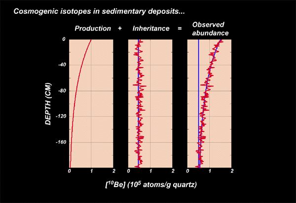
For background, 10-Beryllium is produced in quartz by cosmic-ray interactions with both Si and O. The production rate for 10-Be is about 5.1 atoms/g quartz/year at sea level and high latitude. It increases in a known way as elevation increases or latitude decreases, so we can calculate it anywhere on earth. Production rates at the sites in Altai range from 7 (low elevation -- Platovo dunefield) to 22 (Chuya basin -- high elevation). Higher production rates are good because they mean more atoms to count, which means a more accurate measurement.
The problem with using 10-Be to date sedimentary bedforms is that the sediments which make up the bedform have initial 10-Be, which was produced earlier in their transport history, at the time the bedform is formed. Thus the total 10-Be in a sedimentary surface is equal to this amount, called "inheritance," plus the amount produced since the time of deposition.
Assuming that the sediment is well mixed, this inherited 10-Be should be constant at all depths. However, cosmic rays are attenuated with depth (as an exponential function of density), so production of new 10-Be is slower at depth . Thus the profile of [10-Be] with depth should look as illustrated below: a constant inheritance plus some amount of post-depositional production which decreases exponentially with depth.
The noisy nature of the red line indicating inheritance is to show that we expect some random variation in inheritance with depth. This is one of the major sources of error with this technique, but if the sediment is truly well mixed and we sample a large number of clasts at each depth, the problem is minimized.
Thus, there are two unknowns here. First, the age since deposition. Second, the inheritance at the time of deposition. Thus, we need to sample at two or more different depths to solve for both the time and the inheritance. This is what I did. Sampling at more depths will allow a more accurate fit and help to minimise problems with random noise in the inheritance. Juergen, this is why I asked you to sample at four or five depths at Chuya for me. However, in 1999 I only collected two samples from each pit.
Due to an analytical problem, I do not have all the data for Chuya yet (they are coming) so I will talk mostly about the data from Little Jaloman, Platovo, and Kuray.
First, one way to interpret the data is to calculate the simple age for each surface sample and each deep sample, using different production rates for the surface and at depth. We expect most of these ages to be too old due to inheritance, but they are useful because they tell the maximum age of the landform. Since they represent both inheritance and postdepositional exposure, they must be older than the time of deposition. Here are the ages calculated in this way:
| Site | Depth (cm) | Simple age | +/- |
| Platovo | 0 | 28009 | 863 |
| 75 | 44871 | 1545 | |
| Little Jaloman | 0 | 16203 | 1634 |
| (pit # 1) | 50 | 25323 | 4775 |
| Little Jaloman | 0 | 39173 | 795 |
| (pit # 2) | 50 | 13881 | 918 |
| Kuray | 0 | 26243 | 958 |
| 70 | 46711 | 1758 | |
| Chuya | 50 | 57049 | 1326 |
The youngest of these ages are 14000 and 16000 years BP. If you believe that all the bedforms are the result of the same flood, this means that the last flood must have taken place after 14,000 years BP. However, this might not be true in light of the possibility that the dunes at Little Jaloman have a significantly different exposure history than the others. In this case, the upper limiting age for the remainder of the dunes would be approx. 25,000 BP.
These data also show that the errors in most of these analyses are rather small in most cases. This is a good surprise for us, as the extremely high aluminum content of these quartz samples caused us to use an entirely new preparation procedure which we were not sure about. However, it worked very well for most samples.
The more complicated way to interpret these ages is as the result of inheritance + exposure, as I discussed above. This yields mixed results.
First, here are the data from both pits at Little Jaloman. This plot shows the number of atoms of 10-Be per gram quartz plotted against depth. The lines are the curves fit to the data.
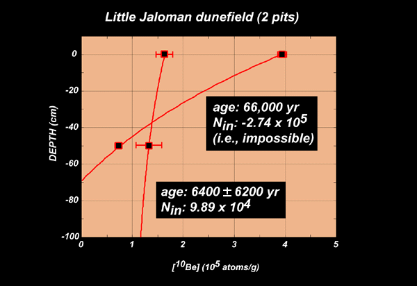
These data are rather discouraging. The two pits from adjacent dunes yielded widely divergent results, one of which is not consistent with the inheritance model. One pit has an excess of 10-Be in the surface sample that cannot be explained by inheritance, because it is not present in the sample at 50 cm depth -- this results in calculating a "negative inheritance" which is clearly impossible. The second pit has large analytical errors, which propagate to ridiculously large errors in the age/inheritance model, and gives an anomalously young age of 6400 +/- 6200 yrs BP. The fact that these two pits give results that cannot be interpreted and are not the same indicates that one of our assumptions is wrong: most likely one or more very old clasts were incorporated into the sample and skewed the age, or alternatively the bedforms were partially reactivated at some time after the last flood and a different population of surface clasts was deposited on top of the dunes. Thus it is hard to interpret the data at this site.
Fortunately, the data from Platovo and Kuray are much more encouraging. In fact, these two sites yield very similar results:
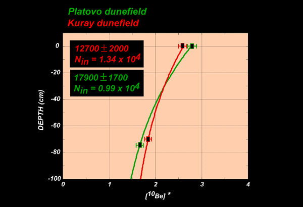
These data overlap at the 1-standard-deviation uncertainty level. Assuming that they are representing the same event, this indicates that the last flood took place at approximately 15,000 +/- 2000 years BP. This is very encouraging because it is about the same as the youngest possible age inferred from taking all the dates as maximum ages, as I discuss above.
Note that since only two samples per pit are used, the error becomes rather large when propagated through the entire calculation. In addition, this error does not include the effect of a random distribution of inheritance, so if the clasts I used were not representative of the entire population the error could be even bigger.
Regardless, it appears from these data that the last flood took place approximately 14,000 years BP. This is not totally certain given the confusing results from the pits at Little Jaloman -- the agreement between Platovo and Kuray could be random. It will be interesting to see the results from the other Chuya sample.
The data also suggest that something is different about the Little Jaloman dunefield. Given the evidence for possible reworking, its significantly smaller size, and position on a terrace below the major flood bars, it is possible that this dunefield may postdate the large floods.
This age for the last flood does conflict with the radiocarbon dates on terrace sediments (which are thought to be post-flood) that Paul mentions in his review paper. In addition, if there was a final flood at about 15,000 BP it does not appear to have disturbed the lacustrine sediments at Inja, which are much older. It also conflicts with the TL age from silt in the Platovo dunefield that Paul reports as well. However, this age from Platovo (and the terrace gravel ages) are already inconsistent with ages from Inja and the Chuya Basin. Thus I don't seem to have added too much more confusion to the picture.