Environmental Gradients in Garrison Bay
Temperature Variation
Along the main transect, temperatures at the high elevation site were greater than those at the low elevation site, for each depth below the surface. Temperatures across the three days were between 10°C to 25°C, except for high temperatures experienced at the surface on July 2 at the high elevation site (Fig. 1B). At both high and low elevation, temperatures fluctuated throughout the day, with peaks in temperature following low tide. Temperatures closer to the surface peaked earlier than those deeper in the sediment, and those at lower elevation peaked earlier than those at higher elevation. We also observed a gradient in temperature variability across depths (see Fig. 2).

|

|
|
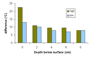
Fig. 2. Difference between the maximum and minimum temperatures (July 1-3, 2004) for each depth below surface and each site (high and low elevation) are shown here. |
The difference between the minimum and maximum temperatures recorded at each depth below the surface decreased with increasing depth, at both the high and low elevation sites (Fig. 2). These results indicate that temperatures fluctuate less at greater depths below the surface, possibly providing protection from temperature stress for organisms in the sediment. The differences in temperature and variability in temperature with depth represent another factor influencing the distribution of organisms throughout the bay. |
Environmental Gradients along the Primary Transect
Depth of clay layer . Along the primary transect, the depth of the hard clay layer generally increased with increasing distance offshore (Fig. 3), while the number of shells and small burrows on the surface fluctuated together (Figure 4). The abundance of shells and small burrows peaked between 7-10m offshore (high elevation), decreased around 15-25m offshore, and increased again, with peaks at about 35m offshore (low elevation). The trend in the number of large burrows differed, with a peak between 7-10m offshore and decreasing thereafter (with the exception of intermittent patches of large burrows further offshore). |
|

Coarse material . The amount of coarse material, consisting mainly of shells with some rocks, varied among samples. We observed positive relationships between the amount of coarse material and the abundance of three surface features: shells, large burrows, and small burrows (Fig. 4). The strength of these relationships was moderate, with the strongest relationship between the amount of coarse material and the abundance of small burrows.
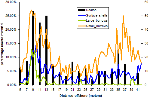
Fig. 4. Summary of environmental factors surveyed along the primary transect, relating distance offshore to the amount of coarse material in the core samples and the abundance of large and small burrows and shells on the sediment surface.
Faunal patterns
Each of the environmental factors was chosen for its potential role as an indicator of the invertebrate composition of different parts of the bay. For example, we hypothesize that the burrows are be related to the presence of polychaetes and bivalves in the substrate, while the amount of coarse material and surface shell material may provide additional microhabitats for these organisms (and be remnants of deceased bivalves).

sample quadrat
However, regression analyses do not suggest any significant relationships between these environmental factors and the abundance of live organisms collected in the core samples, nor the abundance of polychaetes and bivalves when considered separately. Two representative plots are shown in Figure 5; other regression analyses had similar results.
|


Figure 5 Regression analyses of relationships between (top) the number of small burrows and polychaete abundance, and (bottom) the amount of coarse material in the core samples and bivalve abundance. |
[Garrison Bay Main Page] - [Home]