[Note: these pages on Samarkand and some
of its important architectural monuments are "work in progress" and represent in
effect a first draft of what I hope will be expanded and improved as time permits.
So far, the pages contain an introductory overview (immediately below), material on the Bibi Khanum Mosque, the Shah-i Zinde
mausoleum complex, and Ulugh Beg and his observatory, and an
update with photos taken in July 1999. Date of latest
revision, November 7, 1999.]
Samarkand
If it is said that a paradise is to be seen in this world,
then the paradise of this world is Samarkand.
--quoted by 'Ata-Malik Juvaini (Boyle transl.)
Samarkand is one of the oldest and most important cities amongst the many in the
historic region of Central Asia known as 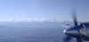 Transoxiana. Located in the Zarafshan
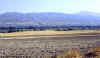 River valley, the city enjoys the benefits of abundant
natural resources and occupies as well a key place on the trade routes of Central Asia.
The Zarafshan is fed by the snow melt from mountains to the south and east (shown here
from the air) and flows into the Oxus (Amu Darya). To travel upstream just above the
fertile valley floor (photo, right), brings one to the historic city of Panjikent.
Downstream is Bukhara. Those who ruled Samarkand developed a complex network
River valley, the city enjoys the benefits of abundant
natural resources and occupies as well a key place on the trade routes of Central Asia.
The Zarafshan is fed by the snow melt from mountains to the south and east (shown here
from the air) and flows into the Oxus (Amu Darya). To travel upstream just above the
fertile valley floor (photo, right), brings one to the historic city of Panjikent.
Downstream is Bukhara. Those who ruled Samarkand developed a complex network 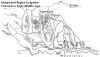 of irrigation channels, as shown in this map. As
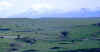 we know from the authors of historic
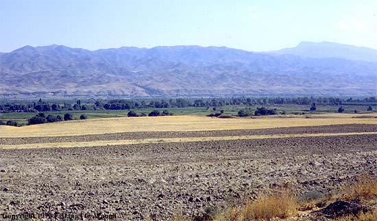
accounts, its surroundings also provided pastureland, something that is evident even today
if we look south from the highlands to the east of the city.
we know from the authors of historic
accounts, its surroundings also provided pastureland, something that is evident even today
if we look south from the highlands to the east of the city.
While settlement in the region goes well back into pre-historic times, by the seventh
century before the Common Era (BCE or B. C.), the town seems to have housed a substantial
center of craft production and already boased an extensive irrigation system. Alexander
the Great knew it as Maracanda; at the time of his conquest in 329 BCE, the city had
strong fortifications and a circumference of some ten kilometers. Alexander's conquests
introduced into Central Asia Classical Greek culture. The Greek legacy lived on in the
various "Graeco-Bactrian" kingdoms of the area and the Kushan Empire of the
first centuries of the Common Era whose territories extended well down into what is today
Pakistan and India. The region was influenced as well by the culture and religions coming
from Iran; it seems likely that the local inhabitants became, among other things,
adherents of Zoroastrianism.
Samarkand is part of a region that historically was known as Sogdia, and whose
ethnically Iranian merchants for centuries seem to have played a key role in the commerce
along the Silk Road. As early as Han times, when the Chinese first recorded their
impressions of Inner Asia, the Sogdians had a reputation as being talented merchants.
Sogdian colonies were established in places such as Dunhuang, one of the important nodes
in the trade route; Sogdian inscriptions on the rocks in the valleys of northern Pakistan
testify to their activity on the routes south into India. We know that some of the exotic
products popular in T'ang China were imported from Samarkand. During the eighth century,
the Sogdians seem to have exercised considerable influence over the Uighurs, neighbors of
T'ang China in the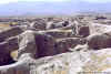 northwest, among other things persuading them to convert to Manichaeism. When the Arabs
invaded Central Asia in the early eighth century, the last of the Sogdian rulers of the
many small states in the Zarafshan Valley fled upriver from Panjikent (a
city whose palaces were decorated with elegant murals) to a fortress on Mt. Mug, where
archaeologists have unearthed a treasure trove of Sogdian documents attesting to the
sophistication of the administration and legal system.
northwest, among other things persuading them to convert to Manichaeism. When the Arabs
invaded Central Asia in the early eighth century, the last of the Sogdian rulers of the
many small states in the Zarafshan Valley fled upriver from Panjikent (a
city whose palaces were decorated with elegant murals) to a fortress on Mt. Mug, where
archaeologists have unearthed a treasure trove of Sogdian documents attesting to the
sophistication of the administration and legal system.
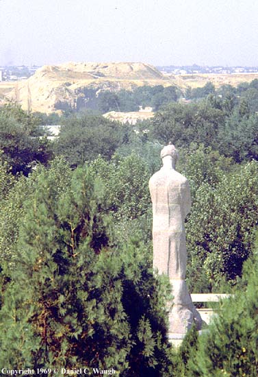
 In Samarkand itself, even after the
Arab conquest, the center of the city continued to be located on the hill known as
Afrasiab, seen here as a dusty mound in the distance as one looks west toward the modern
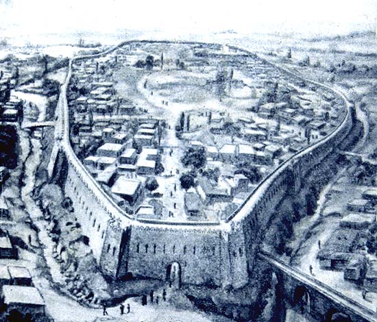
city. As reconstructed by a modern artist, the central fortified area of the city
In Samarkand itself, even after the
Arab conquest, the center of the city continued to be located on the hill known as
Afrasiab, seen here as a dusty mound in the distance as one looks west toward the modern
city. As reconstructed by a modern artist, the central fortified area of the city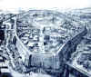 may have looked as shown here on the
right (apparently the view represents it several centuries before the Arab conquest).
Excavations have uncovered the foundations and lower parts of the walls of what appears to
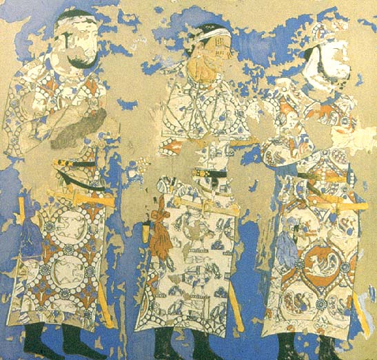
have been the palace of the pre-muslim Sogdian rulers. As in Panjikent, the walls were
covered with brilliant murals, whose fragments shown here seem to illustrate either a
diplomatic procession or some important religious ceremony. The robes of the important
personages reflect the influence of Sasanian (Iranian) designs. It is possible that the
figure at the head of the procession is the Sogdian ruler.
may have looked as shown here on the
right (apparently the view represents it several centuries before the Arab conquest).
Excavations have uncovered the foundations and lower parts of the walls of what appears to
have been the palace of the pre-muslim Sogdian rulers. As in Panjikent, the walls were
covered with brilliant murals, whose fragments shown here seem to illustrate either a
diplomatic procession or some important religious ceremony. The robes of the important
personages reflect the influence of Sasanian (Iranian) designs. It is possible that the
figure at the head of the procession is the Sogdian ruler.
Firm muslim control in the region was not established before the middle of the eighth
century (CE), and a century after that,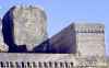 Samarkand came under the control first of the Samanid and
then the Karakhanid states. The Samanids, who were of Iranian origin, established Bukhara
as their capital, and it was under their rule (to about the end of the ninth century) that
the cities of Transoxiana became major centers of Muslim learning. A group of
Samanid memorial stones can be seen today on a platform just in back of the Registan. Like
most successful rulers of the
Samarkand came under the control first of the Samanid and
then the Karakhanid states. The Samanids, who were of Iranian origin, established Bukhara
as their capital, and it was under their rule (to about the end of the ninth century) that
the cities of Transoxiana became major centers of Muslim learning. A group of
Samanid memorial stones can be seen today on a platform just in back of the Registan. Like
most successful rulers of the 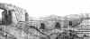 city,
the Samanids invested in the irrigation system. A reconstruction of the possible
appearance of one of the major aqueducts into the city can be seen on the
left. Unfortunately, little remains of the architecture from this period in
Samarkand. Fragments of a Karakhanid-era minaret and mausoleum may be seen in the oldest
of the shrines of the Shah-i Zinde (see the photographs and discussion there).
city,
the Samanids invested in the irrigation system. A reconstruction of the possible
appearance of one of the major aqueducts into the city can be seen on the
left. Unfortunately, little remains of the architecture from this period in
Samarkand. Fragments of a Karakhanid-era minaret and mausoleum may be seen in the oldest
of the shrines of the Shah-i Zinde (see the photographs and discussion there).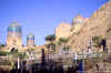
The Persian chronicler Juvaini's encomium to Samarkand and other Central Asian cities
reflects his dismay at the destruction wrought by the Mongols when Chingis Khan invaded
the area in 1220. Only fragments of the walls remained, such as these (on the right in the
picture), which formed the southern boundary of the city near the mausoleum complex of
Shah-i Zinde.
Many of the Central Asian cities quickly recovered from the Mongol invasion.
According to Juvayni, no admirer of the Mongols, Bukhara was one, although by
the early 1330s the famous Arab traveler Ibn Battuta noted "at the present time its
mosques, colleges and bazaars are in ruins, all but a few"--the result apparently of
subsequent wars. Ibn Battuta also visited Samarkand, "one of the greatest
and finest of cities, and most perfect of them in beauty," where he similarly noted
that "there were formerly great palaces on [the river's] bank, and constructions
which bear witness to the lofty aspirations of the townsfolk, but most of this is
obliterated, and most of the city itself has also fallen into ruin. It has no city
wall, and no gates, and there are gardens inside it." The real
rebuilding of Samarkand as a great city had to await the decision by Timur (Tamerlane) to
make it his capital beginning in the 1370s. The Spanish ambassador to
Tamerlane's court, Clavijo, describes how Tamerlane "gave orders...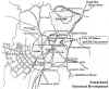 that a street should be built to pass
right through Samarqand, which should have shops opened on either side of it in which
every kind of merchandise should be sold, and this new street was to go from one side of
the city through to the other side, traversing the heart of the township." He
wanted results immediately and those assigned to the task, with their lives at stake,
"began at speed, causing all the houses to be thrown down along the line that his
Highness had indicated for the passage of the new street. No heed was paid to the
complaint of persons to whom the property here might belong, and those whose houses thus
were demolished suddenly had to quit with no warning, carrying away with them their goods
and chattels as best they might. No sooner had all the houses been thrown down than
the master builders came and laid out the broad new street, erecting shops on the one side
and opposite, placing before each a high stone bench that was topped with white slabs.
Each shop had two chambers, front and back, and the street way was arched over with
a domed roof in which were windows to let the light through...At intervals down the street
were erected water fountains." The main axis of the Timurid city
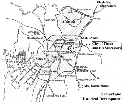
stretched southwest from Afrasiab, passing the Bibi Khanum Mosque and Mausoleum complexes,
then the Registan, and ending near the Gur-i Mir Mausoleum. The development of this urban
center continued apace under Tamerlane's grandson Ulughbeg, who ruled the city for much of
the first half of the fifteenth century until he was assassinated in 1449. Ulugh Beg is
well known for his scientific investigations, supported by the Observatory he built on the
hills to the east of Afrasiab and the madrasa (school) he erected on the Registan.
that a street should be built to pass
right through Samarqand, which should have shops opened on either side of it in which
every kind of merchandise should be sold, and this new street was to go from one side of
the city through to the other side, traversing the heart of the township." He
wanted results immediately and those assigned to the task, with their lives at stake,
"began at speed, causing all the houses to be thrown down along the line that his
Highness had indicated for the passage of the new street. No heed was paid to the
complaint of persons to whom the property here might belong, and those whose houses thus
were demolished suddenly had to quit with no warning, carrying away with them their goods
and chattels as best they might. No sooner had all the houses been thrown down than
the master builders came and laid out the broad new street, erecting shops on the one side
and opposite, placing before each a high stone bench that was topped with white slabs.
Each shop had two chambers, front and back, and the street way was arched over with
a domed roof in which were windows to let the light through...At intervals down the street
were erected water fountains." The main axis of the Timurid city
stretched southwest from Afrasiab, passing the Bibi Khanum Mosque and Mausoleum complexes,
then the Registan, and ending near the Gur-i Mir Mausoleum. The development of this urban
center continued apace under Tamerlane's grandson Ulughbeg, who ruled the city for much of
the first half of the fifteenth century until he was assassinated in 1449. Ulugh Beg is
well known for his scientific investigations, supported by the Observatory he built on the
hills to the east of Afrasiab and the madrasa (school) he erected on the Registan.
The major architectural ensembles of Samarkand, notably those from the Timurid period,
will be explored on separate web pages. The first three, on the Shah-i
Zinde, Ulugh Beg and his observatory, and the Bibi Khanum Mosque, are already available.
For a good survey of Timurid history,
see the University of Calgary History Department's pages from its "Islamic World to
1600."
Historic photos of Samarkand and other cities in Uzbekistan can be found on the UNESCO Virtual Memory of Central Asia
pages.
For a documented overview of "Timurid Architecture in Samarkand" but one not
illustrated with many photos, see Mark Dickens' Oxus Central Asia Site.
Return to Waugh's
Central Asia.
Copyright © 2000 Daniel C. Waugh
Revised May 25, 2000
 River valley, the city enjoys the benefits of abundant
natural resources and occupies as well a key place on the trade routes of Central Asia.
The Zarafshan is fed by the snow melt from mountains to the south and east (shown here
from the air) and flows into the Oxus (Amu Darya). To travel upstream just above the
fertile valley floor (photo, right), brings one to the historic city of Panjikent.
Downstream is Bukhara. Those who ruled Samarkand developed a complex network
River valley, the city enjoys the benefits of abundant
natural resources and occupies as well a key place on the trade routes of Central Asia.
The Zarafshan is fed by the snow melt from mountains to the south and east (shown here
from the air) and flows into the Oxus (Amu Darya). To travel upstream just above the
fertile valley floor (photo, right), brings one to the historic city of Panjikent.
Downstream is Bukhara. Those who ruled Samarkand developed a complex network  of irrigation channels, as shown in this map. As
 we know from the authors of historic
accounts, its surroundings also provided pastureland, something that is evident even today
if we look south from the highlands to the east of the city.
we know from the authors of historic
accounts, its surroundings also provided pastureland, something that is evident even today
if we look south from the highlands to the east of the city.