Change Log
| Changes since v2012 r1.2: | Re‐exported entire integrated database with all Asotin and Columbia and Kittitas updates included. |
| Changes since v2012 r1.1: | Replaced Asotin County pseudo-parcles with new GIS parcels May 15, 2014. Received spatial data from Asotin County in May 2014. Asotin County update only. |
| Changes since v2012 r1.0: | Repaired improperly converted StateLandUseCD values for Kittitas County. |
| 2012 Columbia County Data added March 13, 2013 |
Release Notes
The organizations below produce parcel data in the State of Washington. Due to licensing restrictions or verbal agreements with some counties not all provided data was included in the Statewide Parcel Database. Contact information for acquiring data from restricted counties is provided below.
Data Availability
Data Included
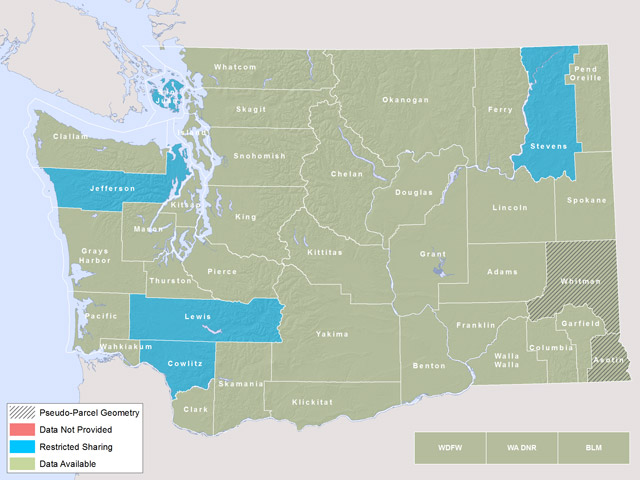
Adams County, Asotin County UDPATE (05/15/2014), Benton County, Chelan County, Clallam County, Clark County, Columbia County UDPATE (03/13/2013), Cowlitz County, Douglas County, Ferry County, Franklin County, Garfield County, Grant County, Grays Harbor County, Island County, Jefferson County, King County, Kitsap County, Kittitas County, Klickitat County, Lewis County, Lincoln County, Mason County, Okanogan County, Pacific County, Pend Oreille County, Pierce County, San Juan County*, Skagit County, Skamania County, Snohomish County, Spokane County, Stevens County, Thurston County, Wahkiakum County, Walla Walla County, Whatcom County, Whitman County#, Yakima County, Washington DNR, Washington DFW, United States BLM
*San Juan requires signed license agreement
#Uses pseudo-parcel geometry
Yakima County provided owner information for the first time for the 2012 database
Did Not Provide Data
UDPATE (03/13/2013) - Columbia County. Columbia county is in the process of upgrading their data. When they are finished, the data will be provided, and an update to the 2012 database will be issued.
Restricted Sharing
Cowlitz County, Jefferson County, Lewis County, San Juan County, Stevens County
 |
Improvement Data
Limited Improvement data is available for the following counties in the 2012 Washington State Parcel Database: Grays Harbor, Island, Jefferson, Kitsap, Mason, San Juan, Skagit, Snohomish, Wahkiakum.
Acquiring Additional Data
Cowlitz County – Did not provide owner information
http://depts.washington.edu/wagis/projects/parcels/producers/producer.php?org=408
Jefferson County – Did not provide owner information
http://depts.washington.edu/wagis/projects/parcels/producers/producer.php?org=416
Lewis County – Did not provide owner information
http://depts.washington.edu/wagis/projects/parcels/producers/producer.php?org=421
San Juan County – Requiring signed license agreement, fill out form here:
http://depts.washington.edu/wagis/projects/parcels/download.php?id=28&table=status&type=license
and e/mail to:
Name: Chris Ledgerwood
Position: Assessor's Cartographer
Organization: San Juan County Assessor's Office
Address: P.O. Box 1519
City, St, Zip: Friday Harbor, WA 98261
Phone: (360) 378-2172
Fax:
Email: chrisle@co.san-juan.wa.us
Stevens County – Did not provide owner information
http://depts.washington.edu/wagis/projects/parcels/producers/producer.php?org=433
Pseudo-Parcels
The following counties were not able to provide spatial GIS data for the 2012 Washington State Parcel Database. To serve as placeholders in the database, pseudo-parcels were generated from parcel id numbers, legal descriptions, and site address information. In most cases these cartoon parcels are randomly located within a mile of their true location, although some are randomly distributed throughout the county when no legal description or parcel id number could be used to geographically locate the pseudo-parcel. Parcel acres from county tax rolls were used to determine the pseudo-parcel size.
Asotin UDPATE (05/15/2014), Whitman
Attribute Metadata
Some limited metadata can be found using ArcCatalog and browsing the metadata for the Parcels feature class, or by following this link: Partially complete FGDC metadata included with the data.
It is a goal to develop complete FGDC metadata for the database. More information will be posted here when it is complete.
Original county data was processed to normalize it for the Washington State Parcel Database. Specific information about how original county attributes became the attributes in the Database can be found on the Data Producers Page.
Contacts
For more information about the project contact:
Luke Rogers
University of Washington, School of Environmental and Forest Sciences
355 Bloedel Hall, Box 352100
Seattle, WA 98195-2100
(206) 543-7418
lwrogers@u.washington.edu
Disclaimers
NEITHER THE UNIVERSITY OF WASHINGTON NOR ANY PARTICIPATING AGENCY MAKES ANY REPRESENTATIONS OR WARRANTIES ABOUT THE ACCURACY OF THE PARCEL DATA INFORMATION OR ABOUT THE SUITABILITY OF THE PARCEL DATA FOR ANY PURPOSE. ALL PARCEL DATA AND RELATED GRAPHICS ARE PROVIDED "AS IS" WITHOUT WARRANTY OF ANY KIND. THE UNIVERSITY OF WASHINGTON AND THE PARTICIPATING AGENCIES HEREBY DISCLAIM ALL WARRANTIES AND CONDITIONS WITH REGARD TO THE PARCEL DATA, INCLUDING ALL WARRANTIES AND CONDITIONS OF (A) MERCHANTABILITY, WHETHER EXPRESS, IMPLIED, OR STATUTORY, AND (B) FITNESS FOR A PARTICULARPURPOSE, TITLE, AND NON-INFRINGEMENT. IN NO EVENT SHALL THE UNIVERSITY AND/OR ANY PARTICIPATING AGENCY BE LIABLE FOR ANY DAMAGES WHATSOEVER RESULTING FROM USE OF THE PARCEL DATA, REGARDLESS OF THE FORM OF SUCH DAMAGES (INCLUDING, WITHOUT LIMITATION, SPECIAL, INDIRECT, AND CONSEQUENTIAL DAMAGES) AND REGARDLESS OF THE FORM OF ACTION IN WHICH SUCH DAMAGES ARE CLAIMED (INCLUDING, WITHOUT LIMITATION, AN ACTION OF CONTRACT OR TORT).
Snohomish County
Snohomish County provides this data or map "as-is" and "with all faults". Snohomish County, any agency, officer or employee thereof disclaims any warranty of merchantability or warranty of fitness of this data or map for any particular purpose, either express or implied. No representation or warranty is made concerning the accuracy, reliability or timeliness of this data or map. Any user of this data or map assumes all responsibility for use thereof, and further agrees to hold Snohomish County harmless from and against any damage, loss or liability arising from any use of this data or map.
I understand that Washington State law, RCW 42.17.260.(9) prohibits the use of lists of individuals for "commercial purposes". I understand that the use for "commercial purposes" of said records may also violate the rights of the individual(s) named therein and may subject me to liability for such commercial use. I understand that "commercial purposes" means that the person requesting the record intends that the list will be used for general business purposes, including but not limited to communicating with the individual(s) named in the record for the purpose of facilitating profit expecting activity.
Known Issues
- StateLandUseCD values were incorrectly translated from the source county data for Kittitas County in Release 1.0. Properly translated data is available in Release 1.1 and any subsequent releases.
