|
Bunchgrass
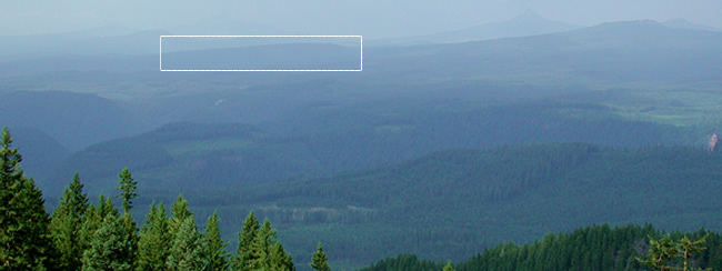
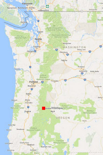
Ridge is a broad, gently sloping plateau in the Cascade Range of western
Oregon (photo,
at bottom). It lies along the boundary of the older, steeply dissected
West Cascades and the younger peaks of the High Cascades (map, at
right). Elevations range from 1220 to 1375 m (4000 to 4500 ft) and
slopes are gentle (<5%), facing primarily southwest. Climate is
maritime, with warm dry summers and cool wet winters. Most precipitation
falls during winter, with >1000 cm of snowfall. Snowpacks can exceed
2 m and persist into late May.
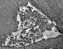
Tree
encroachment. Recent
encroachment of conifers into meadows has been dramatic (see photo-sequence,
at right). For much of the 20th century, the study area
supported a mix of forest and meadow, but many open areas have since been filled by trees. (See our research on the patterns and consequences of conifer invasion at Bunchgrass Ridge) |
|
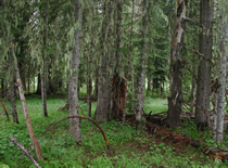
Vegetation. The plateau supports a mosaic of dry meadows, areas of recent encroachment
(<90 yr), and older forests (>100-200 yr) of lodgepole
pine (Pinus contorta) and grand fir (Abies grandis).
Forest understory species are typical of rich, mesic sites (e.g., Smilacina stellata, Achlys triphylla, Galium
oreganum, and Anemone oregana). Meadows
are dominated by graminoids (e.g., Festuca idahoensis, Bromus
carinatus, and Carex pensylvanica [now C. inops]) and a diversity of
forbs. Plant
species list (PDF).
Glacial
history. During
the Pleistocene, glaciers carved valleys to the north and south
of Bunchgrass Ridge and scoured the summit, leaving the current
raised plateau. Lateral moraines (PDF) flank the ridge on the north and south,
and pothole lakes (Kuitan and Robinson) lie to the east.
Soils. Soil pits dug in meadows and forest of varying ages (photo, below) suggest the presence of grassland vegetation for centuries (perhaps millennia). Soils
are deep (>170 cm), fine to very-fine-sandy loams derived from
andesitic basalt and deposits of tephra with variable amounts of
glacially derived cobbles, stones, and boulders. Soil
profiles (PDF).
Disturbance
history. Fires occur infrequently (>100 yr) at this elevation in the Cascades. Native Americans used fire to maintain
open habitats throughout the Northwest, but stumps within the experimental
plots do not show evidence of fire, and archeological surveys have
not produced artifacts indicative of human use of the meadow prior
to Euro-American settlement. |
| Describing a soil profine |
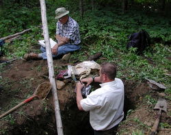 |
| Ted Dyrness (top, deceased) and Duane Lammers (in pit) describe the soil profile in a conifer-invaded meadow (2004). |
|
|
|
|
Grazing
by sheep is likely to have occurred during the early part of the
20th century, when grazing in the Cascades was widespread (Miller 1994).
However, the local history of grazing at Bunchgrass Ridge is not
recorded in Forest Service archives.
Special
Habitat Area designation. Bunchgrass Ridge was designated
as a Special Habitat Area for wildlife in the Willamette
National Forest Land and Resource Management Plan (1990). During the Upper McKenzie Watershed Analysis (1995, update 2006), Bunchgrass was targeted as a high priority
for restoration with these objectives:
- Improve
wildlife use by enhancing forage quality and abundance
- Reduce excessive fuel loadings
- Maintain/restore
grass- and forb-dominated communities
and associated ecological
processes
- Protect/preserve
historic and prehistoric heritage resources
|
|
| Bunchgrass
Ridge (white rectangle) in the western Cascades landscape, viewed
from the south. |
 |
|
|
| Tree
encroachment at Bunchgrass Ridge |
| 1946 |
 |
| 1967 |
 |
| 2000 |
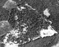 |
| Trees dominating the forest-meadow
mosaic in 1946 had established in the 1800s. Clearcuts adjacent
to the study area are evident in the 2000 photo. |
|
|
 |
_13 Ju 2009_210x155.jpg)