Fuel and Fire Tools (FFT) Introduction
FFT is a software application that integrates the Fuel Characteristics Classification System (FCCS), Consume, FEPS, Pile Calculator, and Digital Photo Series into a single user interface. All of the tools were developed by the Fire and Environmental Research Applications Team (FERA) as open-source and freely sharable software and are supported as separate modules. Fuelbeds are the common currency in FFT. FCCS requires a list of one to many fuelbeds to run calculations. Because Consume and FEPS can predict consumption by burn unit, they require fuelbeds to be assigned to a unit with a percentage area entered for each fuelbed.
- The Fuel Characteristic Classification System stores and classifies fuels data as fuelbeds and calculates fuel loadings, carbon and other summary fuel characteristics. It also predicts surface fire behavior and a 0-9 index of surface, crown fire and available fuel potentials. The FCCS is also available as a command line version and as a module in the Interagency Fuels Treatment Decision Support System (IFTDSS).
- Consume predicts total fuel consumption, pollutant emissions, and heat release for fuelbeds and burn units based on input fuel loadings, fuel moisture, and other environmental factors. It is also available as a command line version and as a module within BlueSky, IFTDSS and WFEIS.
- The Fire Emission Production Simulator FEPS predicts hourly fuel consumption, pollutant emissions, and heat release characteristics of prescribed burns and wildland fires. The FEPS calculator module can be run in command line and has been integrated into BlueSky, IFTDSS, VSmoke.
- The web-based Digital Photo Series (DPS) can be launched within the FFT Fuelbed Editor for reference purposes. It is also available as a separate web-based tool on the FERA website.
- The Pile Calculator is integrated within the Fuelbed Editor to allow creation and editing of pile information within fuelbeds. It is also available as a web-based tool or stand-alone tool on the FERA website.
The FFT runs on Windows Operating Systems (version 7 or greater). The component calculators for FCCS, Consume and FEPS are available as platform independent command line utilities.
Install FFT
FFT can be run on computers with MS Windows operating systems (version 7 and greater). It also requires Java version 1.7 or higher and .NET framework version 4.5 or higher. If you need to update Java to a more recent version, we recommend that you uninstall any older versions of Java prior to installing the update.
-
Download the self-extracting executable file to your computer.
-
Double click the file to launch the installation. The installation program will prompt you for a location to install the FFT. Use the default location - C:\FuelFireTools - unless you have a compelling reason to do otherwise. The installer will install the program, create a shortcut, and start the program.
Run FFT
You can use FFT to calculate summary fuel characteristics (loading, carbon, stratum loading), surface fire behavior, fuel consumption, pollutant emissions, and heat release.
Overview / Quick Start
-
Select the fuelbeds that most closely reflect the area in which you are interested.
-
Customize the fuelbeds in the Fuelbed Editor to better tailor them to your situation (optional).
-
Save the selected fuelbeds as a Burn Unit (optional - both Consume and FEPS require a saved Burn Unit).
-
Specify environmental inputs. Each program FCCS, Consume, and FEPS, require input parameters.
-
Run FCCS, Consume, or FEPS. Note that FEPS depends on outputs from Consume. Consume depends on outputs from FCCS. Therefore, running FEPS runs all 3 programs. Running Consume first runs FCCS. You have access to the results from all programs that have run.
Select Fuelbeds
There are several methods for selecting fuelbeds. The following sections describe them.
Fuelbed Selector
Fuelbeds are the common currency in FFT. FCCS requires a list of one to many fuelbeds to run calculations. Because Consume and FEPS predict consumption by burn unit, they require fuelbeds to be assigned to a unit with a percentage area entered for each fuelbed.
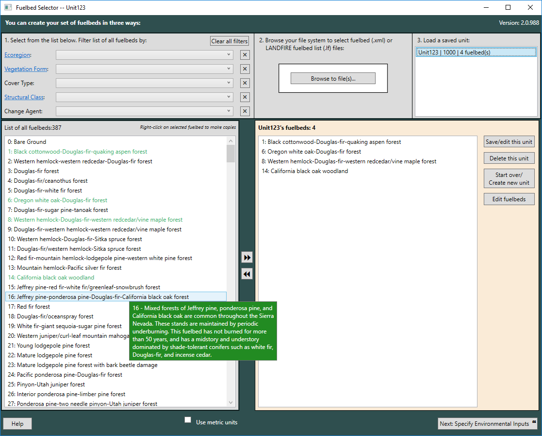
Select fuelbeds by:
-
Moving them from the 'List of all Fuelbeds' on the left to the 'Selected Fuelbeds' listbox on the right. You can select single fuelbeds with a double-click, or multiple fuelbeds by holding down the Shift or Ctrl key while clicking desired fuelbeds with your mouse, then clicking the >> button to add them to the Selected Fuelbeds box.
-
If you know your fuelbeds by their filenames, you can select them from your file explorer interface using the Browse to File button. Over 300 fuelbeds have been preloaded in the FFT and have file names ranging from FB_0000_FCCS.xml to FB_0458_LF.xml. Fuelbeds that you create using the FFT are stored in the <InstallationDirectory>\FCCS\fuelbeds\user folder. To access these, double click on the user folder to view and open user fuelbed files. Fuelbed files are portable and can be shared with other FFT users. If you have additional user fuelbeds from colleagues or from the regional fuelbed datasets on the FERA website, simply copy them into the \fuelbeds\user folder and start a new session of FFT to work with them.
-
Selecting a previously-saved unit from the Load a saved unit box (top-right). When you select a saved unit, the Selected Fuelbeds listbox will display fuelbeds contained in that unit.
After you have selected fuelbeds, you can click the Specify Environmental Inputs button to run FCCS calculations. However, if you wish to run Consume or FEPS, you must first specify a burn unit. To do this on the Fuelbed Selection screen, click the Save/edit unit properties link (top right). You can also save a burn unit from the next screen (Environmental Inputs).
Search variables
Use the search variables in the upper left to trim the fuelbed selection to a more manageable size. Choose from the following variables:
-
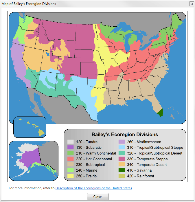
Ecoregions: FCCS fuelbeds are organized geographically into the 14 Bailey ecoregion divisions (Bailey 1989). Fuelbeds may span multiple ecoregions and have more than one ecoregion assigned to them.
See Ecoregion Map
-
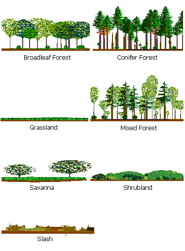
Vegetation Forms: FCCS fuelbeds are classified as being one of the following seven vegetation forms. Only one vegetation form can be selected to represent each fuelbed.
See Vegetation Forms
-
Cover Types: Cover types represent the existing vegetation of an area based on the Society of American Foresters forest cover types (Eyre 1980) and the Society for Range Management rangeland cover types (Shiflet 1994). More than one cover type may apply to each fuelbed.
See all cover types
Cover type
SAF 001: Jack Pine
SAF 005: Balsam Fir
SAF 012: Black Spruce
SAF 013: Black Spruce-Tamarack
SAF 014: Northern Pin Oak
SAF 015: Red Pine
SAF 016: Aspen (Eastern)
SAF 017: Pin Cherry
SAF 018: Paper Birch
SAF 019: Gray Birch-Red Maple
SAF 020: White Pine-Northern Red Oak-Red Maple
SAF 021: Eastern White Pine
SAF 023: Eastern Hemlock
SAF 024: Hemlock-Yellow Birch
SAF 026: Sugar Maple-Basswood
SAF 027: Sugar Maple
SAF 028: Black Cherry-Maple
SAF 030: Red Spruce-Yellow Birch
SAF 031: Red Spruce-Sugar Maple-Beech
SAF 032: Red Spruce
SAF 033: Red Spruce-Balsam Fir
SAF 034: Red Spruce-Fraser Fir
SAF 035: Paper Birch-Red Spruce-Balsam Fir
SAF 037: Northern White Cedar
SAF 038: Tamarack
SAF 039: Black Ash-American Elm-Red Maple
SAF 040: Post Oak-Blackjack Oak
SAF 042: Bur Oak (Eastern)
SAF 043: Bear Oak
SAF 044: Chestnut Oak
SAF 045: Pitch Pine
SAF 046: Eastern Redcedar
SAF 050: Black Locust
SAF 051: White Pine-Chestnut Oak
SAF 052: White Oak-Black Oak-Northern Red Oak
SAF 053: White Oak
SAF 055: Northern Red Oak
SAF 057: Yellow-Poplar
SAF 058: Yellow-Poplar-Eastern Hemlock
SAF 059: Yellow-Poplar-White Oak-Northern Red Oak
SAF 060: Beech-Sugar Maple
SAF 061: River Birch-Sycamore
SAF 062: Silver Maple-American Elm
SAF 063: Cottonwood
SAF 064: Sassafras-Persimmon
SAF 065: Pin Oak-Sweetgum
SAF 066: Ashe Juniper-Redberry (Pinchot) Juniper
SAF 067: Mohr's
SAF 068: Mesquite
SAF 069: Sand Pine
SAF 070: Longleaf Pine
SAF 071: Longleaf Pine-Scrub Oak
SAF 072: Southern Scrub Oak
SAF 073: Southern Redcedar
SAF 074: Cabbage Palmetto
SAF 075: Shortleaf Pine
SAF 076: Shortleaf Pine-Oak
SAF 078: Virginia Pine-Oak
SAF 079: Virginia Pine
SAF 080: Loblolly Pine-Shortleaf Pine
SAF 081: Loblolly Pine
SAF 082: Loblolly Pine-Hardwood
SAF 083: Longleaf Pine-Slash Pine
SAF 084: Slash Pine
SAF 085: Slash Pine-Hardwood
SAF 087: Sweetgum-Yellow-Poplar
SAF 088: Willow Oak-Water Oak-Diamondleaf Oak
SAF 089: Live Oak
SAF 091: Swamp Chestnut Oak-Cherrybark oak
SAF 092: Sweetgum-Willow Oak
SAF 093: Sugarberry-American Elm-Green Ash
SAF 094: Sycamore-Sweetgum-American Elm
SAF 095: Black Willow
SAF 096: Overcup Oak-Water Hickory
SAF 097: Atlantic White-Cedar
SAF 098: Pond Pine
SAF 100: Pondcypress
SAF 101: Baldcypress
SAF 102: Baldcypress-Tupelo
SAF 103: Water Tupelo-Swamp Tupelo
SAF 104: Sweetbay-Swamp Tupelo-Redbay
SAF 105: Tropical Hardwoods (Florida)
SAF 106: Mangrove
SAF 107: White Spruce
SAF 108: Red Maple
SAF 109: Hawthorn
SAF 110: Black Oak
SAF 111: South Florida Slash Pine
SAF 201: White Spruce
SAF 202: White Spruce-Paper Birch
SAF 203: Balsam Poplar
SAF 204: Black Spruce
SAF 205: Mountain Hemlock
SAF 206: Engelmann Spruce-Subalpine Fir
SAF 207: Red Fir
SAF 208: Whitebark Pine
SAF 209: Bristlecone Pine
SAF 210: Interior Douglas-Fir
SAF 211: White Fir
SAF 212: Western Larch
SAF 213: Grand Fir
SAF 215: Western White Pine
SAF 216: Blue Spruce
SAF 217: Aspen (Western)
SAF 218: Lodgepole Pine
SAF 219: Limber Pine
SAF 22: White Pine-Hemlock
SAF 220: Rocky Mountain Juniper
SAF 221: Red Alder
SAF 222: Black Cottonwood-Willow
SAF 223: Sitka Spruce
SAF 224: Western Hemlock
SAF 225: Western Hemlock-Sitka Spruce
SAF 226: Coastal True Fir-Hemlock
SAF 227: Western Redcedar-Western Hemlock
SAF 228: Western Redcedar
SAF 229: Pacific Douglas-Fir
SAF 230: Douglas-Fir-Western Hemlock
SAF 231: Port Orford-Cedar
SAF 232: Redwood
SAF 233: Oregon White Oak
SAF 234: Douglas-Fir-Tanoak-Pacific Madrone
SAF 235: Cottonwood-Willow
SAF 236: Bur Oak (Western)
SAF 237: Interior Ponderosa Pine
SAF 238: Western Juniper
SAF 239: Pinyon-Juniper
SAF 240: Arizona Cypress
SAF 241: Western Live Oak
SAF 242: Mesquite
SAF 243: Sierra Nevada Mixed Conifer
SAF 244: Pacific Ponderosa Pine-Douglas-Fir
SAF 245: Pacific Ponderosa Pine
SAF 246: California Black Oak
SAF 247: Jeffrey Pine
SAF 248: Knobcone Pine
SAF 249: Canyon Live Oak
SAF 25: Sugar Maple-Beech-Yellow Birch
SAF 250: Blue Oak-Digger Pine
SAF 251: White Spruce-Aspen
SAF 252: Paper Birch
SAF 253: Black Spruce-White Spruce
SAF 254: Black Spruce-Paper Birch
SAF 255: California Coast Live Oak
SAF 256: California Mixed Subalpine
SRM 101: Bluebunch Wheatgrass
SRM 102: Idaho Fescue
SRM 103: Green Fescue
SRM 104: Antelope Bitterbrush-Bluebunch Wheatgrass
SRM 105: Antelope Bitterbrush-Idaho Fescue
SRM 106: Bluegrass Scabland
SRM 107: Western Juniper-Big Sagebrush-Bluebunch Wheatgrass
SRM 108: Alpine Idaho Fescue
SRM 109: Ponderosa Pine - Shrubland
SRM 110: Ponderosa Pine - Grassland
SRM 201: Blue Oak Woodland
SRM 202: Coast Live Oak Woodland
SRM 203: Riparian Woodland
SRM 204: Northern Coastal Shrub
SRM 205: Coastal Sage Shrub
SRM 206: Chamise Chaparral
SRM 207: Scrub Oak Mixed Chaparral
SRM 208: Ceanothus Mixed Chaparral
SRM 209: Montane Shrubland
SRM 210: Bitterbrush
SRM 211: Creosote Bush Shrub
SRM 212: Blackbush
SRM 213: Alpine Grassland (Pacific Southwest)
SRM 214: Coastal Prairie
SRM 215: Valley Grassland (Pacific Southwest)
SRM 216: Montane Meadows
SRM 217: Wetlands (Pacific Southwest)
SRM 301: Bluebunch Wheatgrass-Blue Grama
SRM 302: Bluebunch Wheatgrass-Sandberg Bluegrass
SRM 303: Bluebunch Wheatgrass-Western Wheatgrass
SRM 304: Idaho Fescue-Bluebunch Wheatgrass
SRM 305: Idaho Fescue-Richardson Wheatgrass
SRM 306: Idaho Fescue-Slender Wheatgrass
SRM 307: Idaho Fescue-Threadleaf Sedge
SRM 308: Idaho Fescue-Tufted Hairgrass
SRM 309: Idaho Fescue-Western Wheatgrass
SRM 310: Needle-and-Thread - Blue Grama
SRM 311: Rough Fescue-Bluebunch Wheatgrass
SRM 312: Rough Fescue-Idaho Fescue
SRM 313: Tufted Hairgrass-Sedge
SRM 314: Big Sagebrush-Bluebunch Wheatgrass
SRM 315: Big Sagebrush-Idaho Fescue
SRM 316: Big Sagebrush-Rough Fescue
SRM 317: Bitterbrush-Bluebunch Wheatgrass
SRM 318: Bitterbrush-Idaho Fescue
SRM 319: Bitterbrush-Rough Fescue
SRM 320: Black Sagebrush-Bluebunch Wheatgrass
SRM 321: Black Sagebrush-Idaho Fescue
SRM 322: Curlleaf Mountain-Mahogany-Bluebunch Wheatgrass
SRM 323: Shrubby Cinquefoil-Rough Fescue
SRM 324: Threetip Sagebrush-Idaho Fescue
SRM 401: Basin Big Sagebrush
SRM 402: Mountain Big Sagebrush
SRM 403: Wyoming Big Sagebrush
SRM 404: Treetip Sagebrush
SRM 405: Black Sagebrush
SRM 406: Low Sagebrush
SRM 407: Stiff Sagebrush
SRM 408: Other Sagebrush Types
SRM 409: Tall Forb (Great Basin)
SRM 410: Alpine Rangeland (Great Basin)
SRM 411: Aspen Woodland
SRM 412: Juniper-Pinyon Woodland
SRM 413: Gambel Oak
SRM 414: Salt Desert Shrub
SRM 415: Curlleaf Mountain-Mahogany
SRM 416: True Mountain-Mahogany
SRM 417: Littleleaf Mountain-Mahogany
SRM 418: Bigtooth Maple
SRM 419: Bittercherry
SRM 420: Snowbush
SRM 421: Chokecherry-Serviceberry-Rose
SRM 422: Riparian (Great Basin)
SRM 501: Saltbush-Greasewood
SRM 502: Grama-Galetta
SRM 503: Arizona Chaparral
SRM 504: Juniper-Pinyon Pine Woodland
SRM 505: Grama-Tobosa Shrub
SRM 506: Creosotebush-Bursage
SRM 507: Palo Verde-Cactus
SRM 508: Creosotebush-Tarbush
SRM 509: Oak-Juniper Woodland and Mahogany-Oak
SRM 601: Bluestem Prairie
SRM 602: Bluestem-Prairie Sandreed
SRM 603: Prairie Sandreed-Needlegrass
SRM 604: Bluestem-Grama Prairie
SRM 605: Sandsage Prairie
SRM 606: Wheatgrass-Bluestem-Needlegrass
SRM 607: Wheatgrass-Needlegrass
SRM 608: Wheatgrass-Grama-Needlegrass
SRM 609: Wheatgrass-Grama
SRM 610: Wheatgrass
SRM 611: Blue Grama-Buffalograss
SRM 612: Sagebrush-Grass
SRM 613: Fescue Grassland
SRM 614: Crested Wheatgrass
SRM 615: Wheatgrass-Saltgrass-Grama
SRM 701: Alkali Sacaton-Tobosagrass
SRM 702: Black Grama-Alkali Sacaton
SRM 703: Black Grama-Sideoats Grama
SRM 704: Blue Grama-Western Wheatgrass
SRM 705: Blue Grama-Galetta
SRM 706: Blue Grama-Sideoats Grama
SRM 707: Blue Grama-Sideoats Grama-Black Grama
SRM 708: Bluestem-Dropseed
SRM 709: Bluestem-Grama
SRM 710: Bluestem Prairie
SRM 711: Bluestem-Sacahuista Prairie
SRM 712: Galetta-Alkali Sacaton
SRM 713: Grama-Muhly-Threeawn
SRM 714: Grama-Bluestem
SRM 715: Grama-Buffalograss
SRM 716: Grama-Feathergrass
SRM 717: Little Bluestem-Indiangrass-Texas Wintergrass
SRM 718: Mesquite-Grama
SRM 719: Mesquite-Liveoak-Seacoast Bluestem
SRM 720: Sand Bluestem-Little Bluestem Dunes
SRM 721: Sand Bluestem-Little Bluestem Prairie
SRM 722: Sand Sagebrush-Mixed Prairie
SRM 723: Sea Oats
SRM 724: Sideoats Grama-New Mexico Feathergrass-Winterfat
SRM 725: Vine Mesquite-Alkali Sacaton
SRM 726: Cordgrass
SRM 727: Mesquite-Buffalograss
SRM 728: Mesquite-Granjeno-Acacia
SRM 729: Mesquite
SRM 730: Sand Shinnery Oak
SRM 731: Cross Timbers-Oklahoma
SRM 732: Cross Timbers-Texas (Little Bluestem Post Oak)
SRM 733: Juniper-Oak
SRM 734: Mesquite-Oak
SRM 735: Sideoats Grama-Sumac-Juniper
SRM 801: Savanna
SRM 802: Missouri Prairie
SRM 803: Missouri Glade
SRM 804: Tall Fescue
SRM 805: Riparian (Southeastern)
SRM 806: Gulf Coast Salt Marsh
SRM 807: Gulf Coast Fresh Marsh
SRM 808: Sand Pine Scrub
SRM 809: Mixed Hardwood and Pine
SRM 810: Longleaf Pine-Turkey Oak Hills
SRM 811: South Florida Flatwoods
SRM 812: North Florida Flatwoods
SRM 813: Cutthroat Seeps
SRM 814: Cabbage Palms Flatwoods
SRM 815: Unpland Hardwood Hammocks
SRM 816: Cabbage Palm Hammocks
SRM 817: Oak Hammocks
SRM 818: Florida Salt Marsh
SRM 819: Freshwater Marsh and Ponds
SRM 820: Everglades Flatwoods
SRM 821: Pitcher Plant Bogs
SRM 822: Slough (Southeastern)
SRM 901: Alder (Alaska)
SRM 902: Alpine Herb (Alaska)
SRM 903: Beach Wildrye-Mixed Forb
SRM 904: Black Spruce-Lichen
SRM 905: Bluejoint Reedgrass
SRM 906: Broadleaf Forest
SRM 907: Dryas
SRM 908: Fescue
SRM 909: Freshwater Marsh
SRM 910: Hairgrass
SRM 911: Lichen Tundra
SRM 912: Low Scrub Shrub Birch-Ericaceous
SRM 913: Low Scrub Swamp
SRM 914: Mesic Sedge-Grass-Herb Meadow Tundra
SRM 915: Mixed Herb-Herbaceous
SRM 916: Sedge-Shrub Tundra
SRM 917: Tall Shrub Swamp (Alaska)
SRM 918: Tussock Tundra
SRM 919: Wet Meadow Tundra (Alaska)
SRM 920: White Spruce-Paper Birch
SRM 921: Willow
Unknown: Unknown
SAF Cover Types - Eyre, F.H. 1980. Forest cover types of the United States and Canada. Society of American Foresters. 148pp.
SRM Cover Types - Shiflet, T.N. 1994. Rangeland cover types of the United States. Society for Range Management. 165 pp. pdf here
-
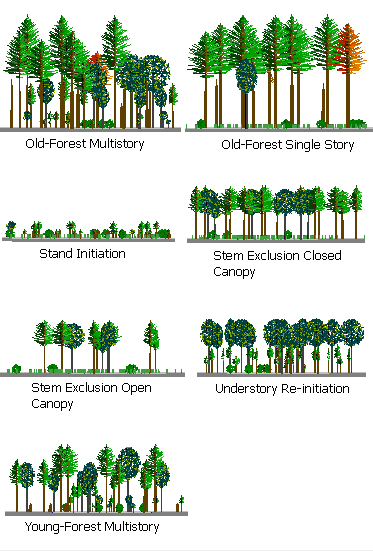
Structural Classes: Fuelbeds with canopy layers are assigned one of seven stand structural classes.
See Structural Classes
-
Change Agents: Change agents are natural or anthropogenic disturbances or management actions that affect fuelbed structure and composition. Multiple change agents may apply to each fuelbed.
See Change Agents
Category Change Agent Definition Change over time
Fire exclusion
Exclusion of fire from a landscape through active suppression, land use changes, and/or cessation of aboriginal burning.
Introduction of exotic species
Invasion of exotic species, which alters native vegetation and/or local fire regimes.
Stand development
Succession of forest vegetation over time.
Fuel treatments
Chipping
Conversion ofwoody fuelsinto small pieces through mechanical chipping.
Lop & scatter
Woody fuels treatment in which fuels are cut into smaller pieces and scattered on site.
Mastication
Conversion of woody fuels into a small, densely packed layer through mechanical grinding.
Pile & burn
Concentration of woody fuels into piles and burning.
Prescribed fire
Application of controlled fire to obtain planned objectives for silviculture, wildlife habitat, grazing, and fire hazard reduction.
Pruning
Removal of the lower branches of trees andshrubs.
Timber harvest
Clearcut
Harvest of all or nearly all trees in a forest stand.
Logging methods/ equipment damage
Damage to vegetation from mechanical fuel treatments and/or timber harvests.
Salvage logging
Dead and/or live tree removal from an area that has burned by a wildfire.
Selection cut
(thin large diameter)Thinning harvest in which large trees are removed from a stand. Sometimes termed "thinning from above."
Stumpwooding
Removal or harvest of stumps.
Thinning (thin from below)
Thinning harvest in which small trees are removed throughout a forest stand to increase growth, decrease ladder fuels, and achieve other management objectives.
Land use change
Ditching/draining
Channeling water away from an area, often creating a drier combustion environment.
Paving
Conversion of wildland fuels to roads and other impervious surfaces.
Natural event
Avalanche
Disturbance to vegetation from snow and/or ice slides.
Blowdown
Wind disturbance to forest stands in which trees are toppled by strong winds.
Flood
Disturbance to riparian and adjacent lands through flooding water courses.
Ice damage
Damage to trees and other vegetation from heavy accumulations of ice and/or snow.
Insects & disease
Mortality of trees and other vegetation from insect attacks and disease, leading to accumulation of dead fuels.
Landslide
Mass wasting event that alters soil and damages and/or removes existing vegetation.
Windthrow
Uprooting of trees from wind and rain events.
No change
Some fuelbeds have no recent change agent and are listed as "no change."
Vegetation treatment Grazing
Management of vegetation for livestock forage and production.
Residual fertilization
Amendments of soil nutrients, often to increase biomass of existing vegetation.
Restoration work
Ecosystem restoration in which fuels are reduced through timber harvest, prescribed burning, and other practices.
Tree planting
Planting trees.
Turpentining
Collection of turpentine from pine trees. This practice generally causes scarring and pitching on tree boles.
Wildfire
Wildfire
An unplanned wildland fire; this category includes unauthorized human-caused fires, escaped wildland fire use events, escaped prescribed fire projects, and all other wildland fires where the objective is to put the fire out.
Wildfire (ground)
A wildfire confined to surface fuels.
Wildfire (crown)
Wildfire that consumes both surface fuels and tree crowns.
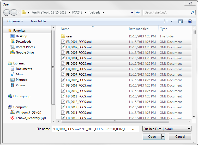
Browse to File
The Browse to File button opens the FCCS\fuelbeds folder within the FFT. Select one to many fuelbeds and click Open. They will now be listed under "Selected Fuelbeds" in the Fuelbed Selection screen.
Only fuelbeds located within the FFT's FCCS\fuelbeds folder (or subfolders thereof) can be selected via Browse to File. To incorporate fuelbeds located elsewhere on your computer, first copy them into FFT's FCCS\fuelbeds\user folder.
LANDFIRE Fuelbed Lists
LANDFIRE supports a 30-m FCCS fuelbed map of the conterminous United States (CONUS), Alaska and Hawaii. To access the raster layers, you can either download them from the online data access page or use the LANDFIRE data access tool as an ArcGIS toolbar.
The FCCS fuelbed layer simply represents FCCS fuelbed IDs. FFT allows you to open the fuelbeds directly from a LANDFIRE attribute table and then run FCCS, Consume and FEPS calculations on that fuelbed list. Tabular outputs in FFT can then be used to join output variables such as fuel loading or predicted consumption and emissions to the original fuelbed raster layer (within ArcGIS or another GIS application) for a spatial display of modeled outputs.
-
From ArcGIS, open the attribute table and export it as a comma-delimited text file (listed as "text file" in the export options box).
-
Rename the ".csv" extension to ".lf" and copy the text file into the FTT fuelbeds folder (for example, c:\FuelFireTools\FCCS\fuelbeds\LF_fuelbeds.lf)
-
Open FFT, click the Browse to File(s) button, and select your LANDFIRE fuelbed list file (e.g., LF_fuelbeds.lf)
-
FFT will populate the Selected Fuelbeds list box with the fuelbeds specified in the text file.
Online documentation of the FCCS LANDFIRE fuelbed layer is here and includes a data dictionary for the attribute table, source fuelbed files (xml format), and source text file of the attribute table (csv format) along with map metadata.
Load a Saved Unit
A burn unit (needed to run Consume or FEPS) is a collection of fuelbeds, saved along with a unit name, unit size and other inputs needed by the calculators. Selecting a saved unit from the "Load a saved unit" listbox will populate the Selected Fuelbeds listbox with that unit's fuelbeds.
Duplicate Fuelbeds
Making fuelbed copies is helpful for creating variations of a single fuelbed. For example, if a forest has undergone different treatment types (e.g., thinning vs. thinning and prescribed burning), you can start with the same source fuelbed and edit the fuelbeds to represent each treatment.
To generate duplicates, right-click on a fuelbed and select 1 to 5 copies. These will be automatically moved to the Selected Fuelbeds listbox and be named as the source fuelbed followed by a "u#". The newly created files will be saved to the FCCS\fuelbeds\user folder. If you need more than 5 copies of a fuelbed, simply repeat the process.
Use Metric Units
To use metric units in the Fuelbed Editor, Burn Unit Editor, reports and graphs, click on the "Use Metric Units" box on the bottom of the Fuelbed Selector screen.
Burn Unit Editor
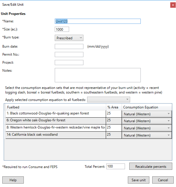
A burn unit is a collection of fuelbeds, saved along with a unit name and size, among other inputs. While Consume and FEPS require that you create a burn unit, FCCS users may find the unit concept helpful for organizing their fuelbeds into named groups. The Burn Unit Form is accessed from the Fuelbed Selector by clicking the 'Save/edit this unit' link beneath the 'Load a saved unit' listbox in the upper right corner of the form.
To define a unit, enter the unit name, size, and percent area and consumption equation for each of the unit's fuelbeds. Other inputs on this form are optional. FFT initially assigns equal area percents to each fuelbed, such that they sum to 100%; click on each value to modify the proportion. The default consumption equation set is Natural (Western). Other options are Activity, which applies to recent logging slash, Natural (Boreal) for boreal and tundra fuelbeds and Natural (Southern) for fuelbeds representative of the southeastern United States. You can either specify a consumption equation by fuelbed row or replace all of them by selecting a consumption equation to apply to all fuelbeds.
Fuelbed Editor
Create User Fuelbeds
To create a custom fuelbed, you must first select an FCCS fuelbed to copy and modify. You can also select the original FCCS fuelbed that you copied if you’d like to have it as a reference while editing the copied fuelbeds, but it will not be editable. It will probably be most efficient to select a fuelbed that has similar vegetation and fuelbed structure to your custom fuelbed. Because you must customize an existing fuelbed in the FCCS fuelbed library, it is important that you review every stratum, category, and subcategory screen to tailor them to your dataset. You can also copy 0:Bare Ground if you wish to start with a blank fuelbed.
Once you have selected a list of fuelbed copies, click the Edit Fuelbeds button to launch the fuelbed editor. The fuelbed editor allows you to view and edit fuelbed data in copied fuelbeds. It displays all fuelbeds within the Selected Fuelbeds listbox on the right of the fuelbed selection screen. An Open Digital Photo Series button is available at the bottom of the Fuelbed Editor if you would like to reference a natural fuels photo series while editing fuelbed data. The editor is organized into tabs, starting with General fuelbed information and then stratum-specific inputs from the Canopy to Ground Fuels.
To edit a cell, simply click on the cell and type in a new value. You can also tab between cells as you would in a spreadsheet. Some input cells allow for multiple entries (e.g., ecoregion, cover type on the Search Variables tab and Species/Relative Cover inputs on stratum tabs). Double-click to edit these cells. A pop-up dialog box allows you to add and delete selections.
FFT validates each entry based on hard limits and some simple validation rules (e.g., tree height to live crown cannot exceed tree height, etc.). If you make a validation error, the entry cell will be highlighted in red with a tool tip detailing the validation error.
To create a custom fuelbed, you must first select an FCCS fuelbed to modify. It will probably be most efficient to select a fuelbed that has similar vegetation and fuelbed structure to your custom fuelbed. Because you must customize an existing fuelbed in the FCCS fuelbed library, it is important that you review every stratum, category, and subcategory screen to tailor them to your dataset. You can also select 0:Bare Ground if you wish to start with a blank fuelbed. An Open Digital Photo Series button is available at the bottom of the Fuelbed Editor if you would like to reference a natural fuels photo series while editing fuelbed data.
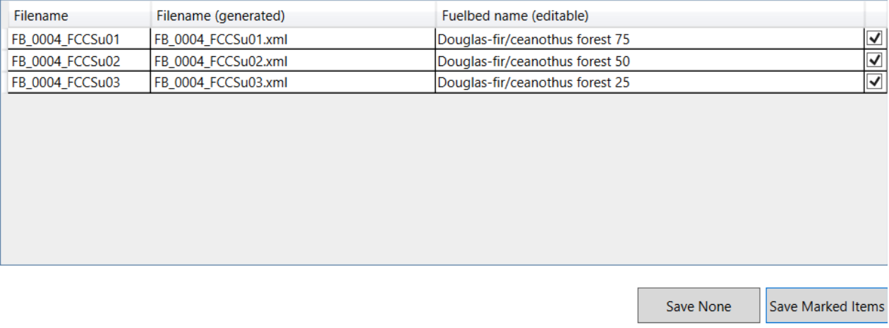
Once you are done editing, click the Save button. FFT will prompt you to save or cancel your changes for each modified fuelbed. Your customized fuelbed(s) will be stored in the FCCS\fuelbeds\user subfolder within your FFT directory. FFT simply adds a "_u" to the original filename. You can change the suggested filename in the second column of the multiple file save dialog box and then click the Save Marked Items button. If you do not wish to save a modified fuelbed, unclick the check box to the right of the fuelbed name or click the Save None button.
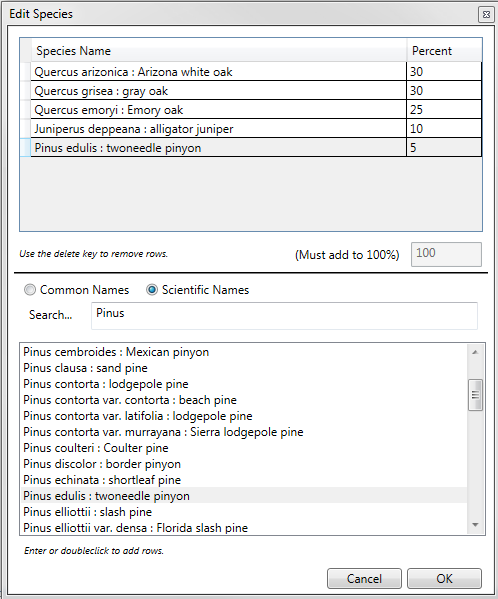
Edit Species
The Relative cover (%)/Species input boxes require entry of at least one species and a corresponding relative cover. Double click on the input cell to open the Edit Species popup box.
- To add a species, double-click on a species from the lower list.
- To search for a species by common name, enter a full or partial common name. Because more than one common name can apply to a species, many common names are not supported.
- To search for a species by scientific name, enter a Genus (capitalized) or Genus and species.
A relative cover must be entered for each species, and total cover must add to 100%. The total relative cover box will be highlighted in red if species percent values do not add to 100%.
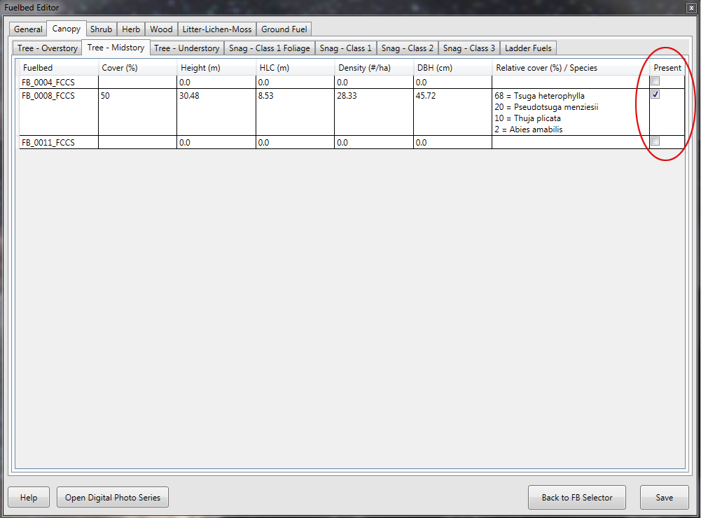
Present Checkboxes
Almost every fuelbed row within the Fuelbed Editor pages contains a Present checkbox. Fuelbeds rarely contain every available fuelbed category. For example, fuelbed 420 is a grassland fuelbed and does not contain any Canopy fuels; input cells are blank for all Tree, Snag and Ladder Fuels tabs, and in each case the Present checkbox is unchecked.
When you are editing fuelbeds, there will likely be categories you wish to either remove or add. You can do this using the Present check box. Using the example of fuelbed 420, if you wished to add an Overstory tree layer, you would need to first check the Present box to enable the row for editing and enter all required values. Similarly, if you wished to remove the secondary herb layer for that same fuelbed, you would click on the Herb -> Secondary Layer tab and uncheck the Present box. The row becomes disabled and is highlighted in red. To restore values, simply check the Present box. Once you save fuelbed changes, however, the original values will be permanently erased.
Input Validation
The fuelbed editor contains minimal input validation. To date, the editor mostly checks if inputs exceed hard limits and contains some error checking of invalid input combinations. Tree inputs, for example, cannot be over 400 feet in height, and height to live crown shouldn't exceed tree height. If your entry exceeds a hard limit or has another validation error, the cell will be outlined in red. If you move the mouse cursor over an input cell highlighted in red, a tool tip will indicate the validation error.
With over 300 possible inputs, care must be taken when editing fuelbeds. Common input errors include:
- Adding height/depth, percent cover or loading data to a fuel category but missing input species and relative cover.
- Entering species relative covers but not summing to 100%
- Overlooking an important total canopy cover input on the Tree: Overstory tab
- Entering percent cover and height in the Herb stratum but not a loading value.
- Entering loading values for sound woody fuels but not an overall depth and percent cover.
- Entering litter dimensions but missing a litter arrangement and type.
- Entering duff dimensions but missing a duff derivation.
General Tab
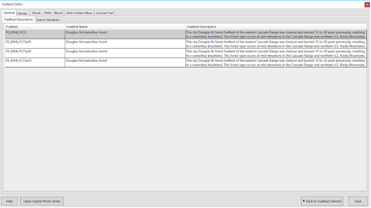
Fuelbed Description
Each fuelbed is assigned a fuelbed filename, name and description.
Fuelbed -- Reference fuelbeds that are part of the FFT installation have a simple file naming convention of FB_0001_FCCS or FB_0300_LF to indicate that fuelbeds were either constructed as part of the original FCCS or for LANDFIRE mapping purposes.
Fuelbed name - Along with the file name, each fuelbed has a descriptive name that generally includes the major vegetation type (e.g., Douglas-fir forest).
Fuelbed description -- The fuelbed description generally contains information of where the fuelbed is located, dominant vegetation, and important change agents.
Note: If you choose to customize a fuelbed, it is a good idea, for reference purposes, to include the source fuelbed as part of your fuelbed name (e.g., a customized fuelbed "FB_0004_FCCS" with a name of Douglas-fir forest will have a default filename of FB_0004_FCCSu01.xml and a user-defined fuelbed name of "FB4 Douglas-fir forest with hand piles").
Search Variables
The fuelbed search variables tab contains the five search variables (ecoregion, vegetation form, cover type, change agent and stand structural class) along with three other descriptive fields. Many of the fields allow for multiple inputs. To edit or add data, double click on an input field and then make your selections from the popup dialog box.
- Ecoregion - Bailey's ecoregion division. Double click to edit.
- Vegetation form - Type of vegetation. Select one from dropdown list
- Cover type - SAF or SRM vegetation cover type. Double click to edit.
- Stand structural class - Forest structural class. Select one from dropdown list.
- Change agent - Major disturbance or change agent. Double click to edit.
-
Natural fire regime - Natural fire regime (Hann et al. 2004) is recorded as part of the fuelbed description. It is an optional input but has been assigned to all reference fuelbeds.
Definitions:
- 0-35 year frequency and low severity (most commonly associated with surface fires) to mixed severity (in which less than 75% of the dominant overstory vegetation is replaced.)
- 0-35 year frequency and high severity (stand replacement; greater than 75% of the dominant overstory vegetation is replaced).
- 35-200+ year frequency and mixed severity (<75% of dominant overstory vegetation is replaced).
- 35-200+ year frequency and high severity (stand replacement).
- 200+ year frequency and high severity (stand replacement).
-
Condition class - Fuelbeds can be assigned a fire regime condition class including:
Class 1: Fire regimes are within the natural (historical) range, and the risk of losing key ecosystem components is low. Vegetation attributes (species composition, structure and pattern) are intact and functioning within the natural (historical) range.
Class 2: Fire regimes have been moderately altered from their natural (historical) range. Risk of losing key ecosystem components is moderate. Fire frequencies have departed from natural frequencies by one or more return intervals (either increased or decreased). This results in moderate changes to one or more of the following: fire size, intensity and severity, and landscape patterns. Vegetation and fuel attributes have been moderately altered from the natural (historical) range.
Class 3: Fire regimes have been substantially altered from their natural (historical) range. The risk of losing key ecosystem components is high. Fire frequencies have departed from natural frequencies by multiple return intervals. Dramatic changes occur to one or more of the following: fire size, intensity, severity and landscape patterns. Vegetation attributes have been substantially altered from their natural (historical) range.
Reference: https://www.frames.gov/files/7313/8388/1679/FRCC_Guidebook_2010_final.pdf
-
Data quality ranking - Reference fuelbeds were created from published literature, grey literature, online databases and expert opinion (Riccardi et al. 2007). A data quality ranking is assigned to each of the reference fuelbeds and indicates the level to which fuelbeds have been created from published values.
- No data (no hard numbers for any data value)-created from experience and/or ecological literature
- Partial data-less than 35% of mode inputs from literature, photo series, or peer-reviewed data source
- Partial data-35-85% of mode inputs from literature, photo series, or peer-reviewed data source
- Data driven-85-100% of inputs from photo series or peer-reviewed data source
- Data driven-85-100% of all data (min, max, mode) from photo series or peer-reviewed data source
Reference: Riccardi, C.L., Ottmar, R.D., Sandberg, D.V., Andreu, A., Elman, E., Kopper, K., and Long, J. 2007. The fuelbed: a key element of the fuel characteristic classification system. Canadian Journal of Forest Research. 37(12): 2394-2412.
Stratum Tabs
Canopy Stratum
The canopy stratum has three categories including trees, snags and ladder fuels. Canopy variables are on the second tab on the FCCS editor. Many fuelbeds are missing canopy layers or, in the case of some grassland and shrub lands, may be missing a canopy stratum altogether. In these cases, some or all panels are grayed out, and the Present button is unchecked. A tool tip with the name of each stratum or category appears as you position your mouse on each sub tab, including:
- Overstory (tree ): Uppermost canopy layer, including emergent, dominant and codominant trees.
- Midstory (tree ): Intermediate canopy layer, including trees below the overstory and above the understory.
- Understory (tree ): Lowermost canopy layer including seedlings, saplings and other small trees.
- Class 1 Foliage (snag ): Recently-dead conifers that still have most of their foliage in addition to bark, branches and tree top.
- Class 1 (snag ): Recently-dead trees that still have bark, branches and top intact.
- Class 2 (snag ): Snags that have shed fine branches but retain coarse branches and bark.
- Class 3 (snag ): Snags with extensive heartwood decay and that no longer have bark, branches or a tree top.
- Ladder Fuels: Ladder fuels can provide vertical continuity between surface fuels and crown fuels and contribute to torching and crowning potentials. In forests where ladder fuels are present, you can enter ladder fuel type, minimum and maximum height and specify if there is vertical continuity between the lower strata and canopy,.
Editing tips:
- If your fuelbed has only one tree canopy layer, enter it in the Overstory and unclick the Present checkbox in the Midstory and Understory.
- Total canopy cover is input on the Tree - Overstory tab and represents the total cover of all canopy layers by ground projection.
|
Variable |
Definition |
English Units |
Metric Units |
|
Cover |
Percentage cover by crown projection in each canopy layer. |
Percentage |
Percentage |
|
Height |
Height of vegetation in each canopy layer. |
Feet |
Meters |
|
HLC/HLB |
Height to Live Crown/Base in each canopy layer. |
Feet |
Meters |
|
Density |
Density of each canopy layer |
Stems/acre |
Stems/hectare |
|
DBH |
Diameter at Breast Height |
Inches |
Centimeters |
|
Relative cover |
Relative cover of species (%) in each canopy layer. Must sum to 100%. |
Percentage |
Percentage |
|
Species |
Scientific name. |
Shrub Stratum
The shrub stratum describes shrubs in primary and secondary layers.
-
Primary layer: Main shrub layer distinguished by height, form, species composition or any other user-defined characteristic.
-
Secondary layer: Secondary (and optional) vegetation layer.
Editing tips:
- If shrub strata are covered in needle drape that would be expected to contribute to fire behavior, this is indicated by a "yes" in the needle drape column.
- If your fuelbed has only one shrub layer, enter it into the primary shrub layer and uncheck the Present button in the secondary shrub layer. You can define the two shrub layers by any number of characteristics including shrub layer height, form, or species composition.
- Percentage live refers to the percentage of biomass that is live in the shrub layer, not simply the percentage of individuals that are live.
- Shrub loading is an optional input and is calculated by FCCS if the input remains zero.
Variable |
Definition |
English Units |
Metric Units |
Cover |
Percentage cover by crown projection in each shrub layer. |
Percentage |
Percentage |
Height |
Height of vegetation in each shrub layer. |
Feet |
Meters |
Percent live |
Percentage of biomass that is alive in each shrub layer. |
Percentage |
Percentage |
Needle drape |
Is the needle drape on the shrub component sufficient to affect the surface fire behavior? |
Yes or No |
Yes or No |
Loading |
Optional shrub loading. If left at zero, FCCS will calculate the loading. |
Tons per acre |
Megagrams per ha |
Relative cover |
Relative cover of species (%) in each shrub layer. Must sum to 100%. |
Percentage |
Percentage |
Species |
Scientific name. |
|
|
Herb Stratum
The herb stratum describes herbaceous vegetation including grasses, sedges, rushes and forbs in primary and secondary layers. Not all fuelbeds contain an herb stratum or both herb layers.
- Primary layer - Main vegetation layer distinguished by height, form, species composition or any other user-defined characteristic.
- Secondary layer - Secondary (and optional) vegetation layer.
Editing tips:
- If your fuelbed has only one herb layer, enter it into the primary layer and uncheck the Present button in the secondary herbaceous fuels layer.
- You can define the two herb layers by any number of characteristics including height, form, and/or species composition. For example, forbs and grasses are generally placed in separate layers.
- Percentage live refers to the percentage biomass that is alive in the stratum, not the percentage of individuals that are alive. Percentage live generally reflects growing season conditions unless the fuelbed is specific to another season.
Variable |
Definition |
English Units |
Metric Units |
Cover |
Percentage cover in each layer. |
Percentage |
Percentage |
Height |
Height of vegetation in each layer. |
Feet |
Meters |
Percent live |
Percentage of biomass that is alive in each herb layer. |
Percentage |
Percentage |
Loading |
Optional herb loading. If left at zero, FCCS will calculate the loading. |
Tons per acre |
Megagrams per ha |
Relative cover |
Relative cover of species (%) in each shrub layer. Must sum to 100%. |
Percentage |
Percentage |
Species |
Scientific name. |
|
|
Wood Stratum - downed and dead wood
The Wood Stratum includes downed and dead wood, stumps and piles. The FCCS surface fire behavior equations rely on cover, depth and loading inputs for fine, sound wood (1-hr, 10-hr, and 100-hr) classes. Other wood categories apply to fuel loading, carbon and consumption/emissions calculations.
Sound wood - downed and dead wood with minimal decay by timelag size class.
Rotten wood - partially decomposed downed and dead wood by timelag size class.
Variable |
Definition |
English Units |
Metric Units |
Cover |
Percent cover of 1-hr, 10hr and 100-hr sound wood |
Percent |
Percent |
Depth |
Depth of 1-hr, 10-hr, and 100-hr sound wood |
Inches |
Centimeters |
1-hr |
Loading of ≤ 1 inch sound wood. |
Tons per acre |
Megagrams per ha |
10-hr |
Loading of >1/4 to ≤1 inch sound wood. |
Tons per acre |
Megagrams per ha |
100-hr |
Loading of >1 to 3 inch sound wood. |
Tons per acre |
Megagrams per ha |
1000-hr |
Loading of >3 to 9 inch) sound or rotten wood. |
Tons per acre |
Megagrams per ha |
10,000-hr |
Loading of >9 to 20 inch sound or rotten wood. |
Tons per acre |
Megagrams per ha |
>10,000-hr |
Loading of >20 inch sound and rotten wood. |
Tons per acre |
Megagrams per ha |
Relative cover |
Relative cover of species (%) in all sound wood categories. |
Percentage |
Percentage |
Scientific name |
Scientific name of species in all sound wood categories. |
|
|
Wood Stratum - stumps
Sound stumps - stumps with minimal decay.
Rotten stumps - stumps that are partially decomposed.
Lightered/pitchy stumps - stumps that contain concentrations of pitch and other resinous volatiles and burn vigorously.
Variable |
Definition |
English Units |
Metric Units |
Height |
Height of stumps in each category. |
Feet |
Meters |
Diameter |
Diameter of stumps in each category. |
Inches |
Centimeters |
Density |
Number of stumps per unit area in each category. |
Stems per acre |
Stems per hectare |
Relative cover |
Relative cover of species (%) in all rotten wood categories. Must sum to 100%. |
Percentage |
Percentage |
Scientific name |
Scientific name of species in each stump category. |
|
|
Wood Stratum - piles
Piles are defined as accumulations of woody fuels, including natural fuel accumulations ("jackpots"), hand piles and machine piles. FERA's pile calculator has been incorporated into the Fuelbed Editor to facilitate calculation of pile volume and biomass. On the Pile tab, right-click a fuelbed row to either create/edit or delete pile information. In this example, FB_0004 is highlighted. Right-clicking on the row will open the pile editor (see below).
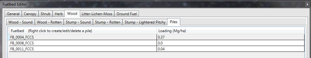
Piles of the same dimensions are saved as "pile groups." You may specify multiple pile groups to represent the piles within your fuelbed. In this example, three pile groups were added to represent 10 hand piles, 2 landing piles and 5 additional machine piles.
To view edit existing pile group data, double click the row. Hand and machine pile algorithms require different inputs (see table below).
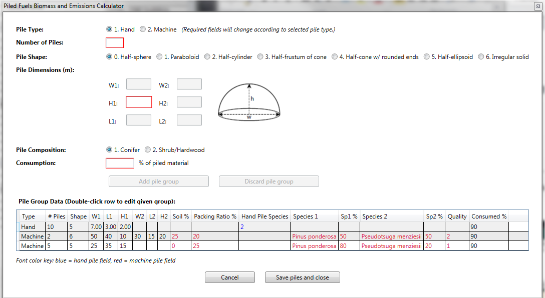
Variable |
Definition |
English Units |
Metric |
Pile type |
Hand or machine pile calculations are supported. Pile type changes the required inputs based on equation specifications. |
|
|
Number of piles |
Total number of piles. If you have piles per area, multiply by area to enter the total number. |
|
|
Pile shape |
Select the option that best represents the shape of your pile group. |
|
|
Pile dimensions |
The number of required pile dimensions varies by pile shape. W = width, H = Height, and L = Length. |
Feet |
Meters |
Pile composition |
Conifer or shrub/hardwood. Applicable to hand piles only. |
|
|
Consumption |
Percent consumption of piled material. A recommended default is 90%. |
Percent |
Percent |
Percent soil |
Percentage soil by volume. Applicable to machine piles only. |
Percent |
Percent |
Packing ratio |
Specify how densely packed the pile is (10% for piles with a lot of air space, 20% for densely packed piles, and 25% for high density piles with large logs). Applicable to machine piles only. |
|
|
Pile species composition |
Enter a primary and optional secondary species to specify a wood density. Applicable to machine piles only. |
Percent |
Percent |
Pile quality |
Specify whether the material within the pile is clean, dirty or very dirty. Applicable to machine piles only. |
|
|
Litter-Lichen-Moss Stratum
Litter - Top layer of the forest or rangeland floor; composed of loose debris of dead sticks, branches, twigs, dead grass, and recently fallen leaves or needles that has been minimally altered by decomposition.
Lichen - Ground lichens occurring on rocks, bare ground or low vegetation.
Moss - Low-growing bryophytes; usually occurring in moist habitats.
- Percentage cover and depth are required for each layer.
- The litter layer requires users to select an overall litter arrangement and enter relative cover by litter type(s).
- The moss layer requires users to designate a moss type (other moss or sphagnum moss).
- Loading is an optional input. If left a zero, FCCS will calculate the fuel loading of each layer based on input cover, depth, litter arrangement and type.
Variable |
Definition |
English Units |
Metric Units |
Depth |
Total depth of litter, lichen or moss layer. |
Inches |
Centimeters |
Cover |
Total percentage cover of litter, lichen or moss layer based on linear coverage. |
Percentage |
Percentage |
Loading |
Optional fuel loading by layer. If left at zero, FCCS will calculate the loading. |
Tons per acre |
Megagrams per ha |
Litter arrangement |
3 arrangements (select one):
|
|
|
Litter type |
Multiple types can apply:
|
|
|
Relative cover |
Relative cover of each litter type (%). Must sum to 100%. |
Percentage |
Percentage |
Moss type |
2 types (select one):
|
|
|
Ground Fuels Stratum - duff
Duff - Partially to fully decomposed organic material between the LLM stratum and mineral soil. Duff is described in two layers: an upper layer representing the Oe soil horizon and a lower layer representing the Oa soil horizon. These layers are also called fermentation and humic layers, respectively, by some fuels specialists and foresters.
| Variable | Definition |
English Units |
Metric Units |
Cover |
Percentage cover of the upper or lower duff layers based on linear coverage. |
Percentage |
Percentage |
Depth |
Depth of upper or lower duff layer. |
Inches |
Centimeters |
Type |
Upper duff types (select one):
Lower duff types (select one):
|
|
|
Loading |
Optional loading by layer. If left at zero, FCCS will calculate the loading. |
Tons per acre |
Megagrams per ha |
Ground Fuels Stratum - basal accumulations
Basal accumulations are mounds of bark, downed woody debris, litter and duff surrounding tree trunks. The radius of a basal accumulation is measured from the outer edge of the tree trunk to the outer edge of the accumulation.
| Variable | Definition |
English Units |
Metric Units |
Depth |
Depth of basal accumulation of ground fuels around tree trunks. |
Inches
|
Centimeters
|
Radius |
Radius of basal accumulation of ground fuels around tree trunks. |
Feet
|
Meters
|
Density |
Number per area of basal accumulations. |
Number per acre (0-50,000) |
Number per hectare (0-127,000) |
Type |
7 types (select one):
|
|
|
Loading |
Optional fuel loading of basal accumulations. If left at zero, FCCS will calculate the loading. |
Tons per acre |
Megagrams per ha |
Ground Fuels Stratum - squirrel middens
Squirrel middens are mounds of cone scales and other cone debris accumulated over time from squirrels extracting seeds. The mounds are composed exclusively of organic matter that can burn for extended periods of time.
| Variable | Definition |
English Units |
Metric Units |
Depth |
Depth of squirrel middens. |
Inches |
Inches |
Radius |
Radius of squirrel middens. |
Feet |
Meters |
Density |
Density of squirrel middens. |
#/acre |
#/acre |
Loading |
Optional loading by layer. If left at zero, FCCS will calculate the loading. |
Tons/acre |
Megagrams per ha |
Environmental Variables
Before you run calculations, you need to specify an environmental input scenario. If you have already saved an environmental input scenario, double-click it in the top left box to load those values. Partial entries (e.g., inputs that only pertain to FCCS) are allowed, but Consume requires both FCCS and Consume inputs, and FEPS requires all three panels to be filled out.
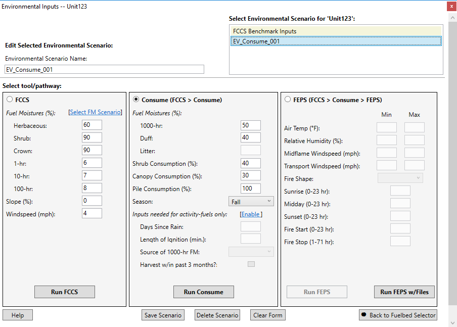
FCCS Variables
FCCS calculations can be made using the default scenario (FCCS Benchmark Inputs) or from custom inputs.
- To create a custom scenario for FCCS calculations, enter environmental variables for the FCCS pathway, enter an Environmental Scenario Name, and click the Save Scenario button.
- A list of 16 pre-loaded fuel moisture (FM) scenarios can be selected by clicking Select FM Scenario link and double-clicking a FM row.
Consume Variables
Consume variables - The Consume calculator requires that selected fuelbeds are saved as a burn unit. If you have not already done so, select the Consume radio button at the top of the Consume panel to open the “Save burn unit?” dialog box. Select OK to open the “Save/edit unit” dialog box. Unit name and size are required inputs.
- The Consume calculator requires both FCCS and Consume environmental inputs. Click on the Consume radio button to enter inputs for Consume.
- If any fuelbeds in your burn unit are specified as Activity fuels, you will need to enter additional environmental inputs (days since rain, length of ignition, source of 1000-hr FM, and Harvest within 3 months?)
FEPS Variables
FEPS can use inputs made on the environmental variables screen (Run FEPS) or with (Run FEPS with files).
The environmental inputs in the following table are required for each FEPS run. These parameters represent a 24-hour period for now. FEPS is under active development and will soon be modified to support wildland fire events that span multiple days. Once you enter values for these parameters, those values are used in the weather model to populate the hourly meteorological data. You can modify the hourly meteorological data values.
Advanced FEPS
FEPS users that have FOFEM consumption results or hourly meteorological data may wish to bypass intermediate calculations in FEPS and provide their own intermediate files. To do this, click on the "Run FEPS with Files" button on the Environmental Variables screen. To create sample intermediate files, you can first run FEPS normally (using the Run FEPS button) and then find the files in the c:\FuelFireTools\00_results\feps folder).
The three intermediate files are:
- Runfeps.csv: contains consumption data (from Consume) and environmental variables inputs
- Diurnal_out.csv: contains hourly meteorological data, generated from FEPS based on environmental inputs
- Growth_out.csv:
Results
The FFT Results Screen shows the options for viewing results:
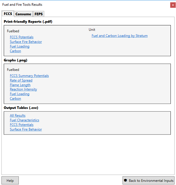
Various views of the calculated results are available in packaged reports and graphs. Both reports and graphs can be printed. NOTE: viewing the pdf reports requires that you have a pdf viewer on your system. There are several free pdf viewers - Adobe reader is popular.
Custom Analysis
All of the calculated results for each calculator are exposed in the tabular output (csv) files. If your needs go beyond our packaged reports and graphs, you can do additional processing in python, R, or any application that understands the csv format.
Run from a Command Prompt
All of the calculators in FFT (FCCS, Consume, and FEPS) can be run from the command line. Get detailed usage instructions by running the application without arguments.
FCCS
FCCS is a Java application and is packaged in a jar file. Location is c:\FuelFireTools\FCCS\fuelbed.jar
C:\FuelFireTools\FCCS>java -jar fuelbed.jar

Error: no input files specified!


*** ============================================================ ***
FCCS Fuel Characteristics Calculator Version: 3.0.259
        This program calculates various fuel characteristics. It can also create
        a fuel loadings file for the Consume fuel consumption and emissions program.

        Options:
                -h, --help:     Help text
                -p, --param:    Specify environmental parameters to the calculator
                                (windspeed, slope, moisture_id, moisture_file)
                -g, --generate:         Generate a Consume fuel loadings file.
                -o, --output_filename:  Specify the name for the results file.
                -d, --dump_heap:        Debugging switch.
                -l, --consume_loadings_filename:        Specify the name for the Consume fuel loadings file.

                The moisture file format is comma separated values (csv) with the following columns:
                        oneHourFM,tenHourFM,hundredHourFM,liveNonWoodyFM,liveShrubFM,crownFM

        Specify any necessary options and the files to process.
        Calculated output goes to "fccs_summary.csv" by default.
        The optional Consume loadings file is "consume_loadings.csv" by default.

        Examples:
                java -jar fuelbed.jar my_fuelbed.xml
                java -jar fuelbed.jar ..\data\fuelbeds\*.xml
                java -jar fuelbed.jar ..\data\fuelbeds\*.xml -o c:\myresults\results.csv
                java -jar fuelbed.jar -p windspeed=10  -p slope=40 ..\data\fuelbeds\*.xml

Elapsed: 0m 0s Files processed: 0
Consume
Consume is written in Python. Run it from c:\FuelFireTools\Consume\consume_batch.python
    C:\FuelFireTools\Consume>..\bin\python.exe consume_batch.py
    usage: consume_batch.py [-h] [-f loadings file] [-x output columns]
                            [-l message level] [--metric] [-o output filename]
                            [burn type      (activity | natural)]
                            [input file     csv format]

        Consume predicts fuel consumption, pollutant emissions, and heat release
        based on input fuel loadings and environmental variables.  This command
        line interface requires a specified burn type (either activity or natural),
        environmental variables input file (csv format), and fuel loadings file
        (generated by FCCS 3.0, csv format), and.  A sample fuel loadings file
        (fuel_loadings.csv) and environmental inputs file (input.csv) have been
        provided. For more information on FCCS input files and results,
        please see: LINK.

    positional arguments:
      burn type     (activity | natural)
      input file    (csv format)

    optional arguments:
      -h, --help            show this help message and exit
      -f loadings file      Specify the fuel loadings file for consume to use. Run
                            the FCCS batch processor over the fuelbeds for which
                            you want to generate consumption/emission results to
                            create a fuel loadings file.
      -x output columns     Specify the output column configuration file for
                            consume to use
      -l message level      Specify the detail level of messages (1 | 2 | 3). 1 =
                            fewest messages 3 = most messages
      --metric              Indicate that columns should be converted to metric
                            units.
      -o output filename    Specify the name of the Consume output results file.

    Examples:
        // display help (this text)
        python consume_batch.py

        // Simple case, natural fuel types, required input file (uses built-in loadings file)
        python consume_batch.py natural input_natural.csv

        // Specify an alternative loadings file
        consume_batch.exe natural input_natural.csv -f my_loadings.xml

        // Specify a column configuration file. Please see the documentation for details.
        consume_batch.exe activity input_activity.csv -x output_summary.csv
FEPS
FEPS is a C++ application. Run it from c:\FuelFireTools\FEPS_2\feps.exe
C:\FuelFireTools\FEPS_2>feps
FEPS Single Executable : Version - 2.0.200
usage:
    feps <options>

options:
    -b FILE    Basic input file (required scenario#1 and scenario#2)
    -e FILE    Emissions input file (required scenario#1 and scenario#2. Consume can produce this file)
    -i         Flag: if present write intermediate files (optional scenario#1, invalid scenario#2)
    -g FILE    Time profile file (required scenario# 2, invalid scenario#1)
    -d FILE    Diurnal weather file (required scenario# 2, invalid scenario#1)
Fuelbed Converter
Custom fuelbeds created in the stand-alone version of FCCS (version 2.2 or earlier) need to be converted to the FCCS 3.0 format before they can be used in FFT.
C:\FuelFireTools\Tools>java -jar fuelbed_converter.jar

Use to convert FCCS 2.x fuelbeds to the current 3.x format.
Files will first be validated against the 2.x schema. Invalid files will NOT be converted

1.) Navigate to the directory containing the fuelbeds to convert
2.) Invoke the conversion command
3.) Files that have been successfully converted will be in the "000_Output" directory.

An example:
        java -jar fuelbed_converter.jar *.xml

If you have "in between" fuelbeds (newer than version 2 but not version 3) use the "/2" switch
        java -jar fuelbed_converter.jar /2 *.xml

NOTE: this doesn't validate the input files against any schema, it simply tries to apply the appropriate conversions.