During August 20-21, 2024, the Northeastern Indian state of Tripura, which is mountainous, received heavy rainfall leading to destructive flooding and loss of life. In addition, the lack of preparation for such a rapid onset of extreme flooding impacted more than a million people forcing 80,000 individuals into the 557 makeshift relief camps set up by the Tripura State Government.
As the flood travelled downstream crossing the international boundary with low lying Bangladesh, people there were also caught off guard due to lack of flood preparedness. Tripura had to open the gate of its sole hydro-electric dam called Dumboor (the first time in 31 years). As news of the Dumboor dam opening spread, conspiracy theories and conjectures became rife within Bangladesh, particularly in social media. Did India intentionally flood Bangladesh by opening the gate of Dumboor dam? Was it really such a heavy and widespread rainfall event that the dam played no role in making downstream flooding worse? Could India (Tripura Government) not have warned downstream authorities in Bangladesh? Etc etc.
Amid such wild speculations by many sections of the public and a catastrophic flooding needing rapid disaster response and relief, the question that was posed by the SASWE Research Group of University of Washington was “how can we improve livelihoods through sustainable application of earth science, remote sensing and advanced information technology?” This is the core SASWE research philosophy. In other words “what can Earth observations and data science do to make a positive impact for everyone?”
This question takes particular importance in the era of the Surface Water and Ocean Topography (SWOT) satellite mission that was launched in December 2022 and has started streaming data for the public on surface water. SWOT makes the Tripura-Bangladesh situation particularly unique and exciting as it can measure water elevation and inundation extent to provide a more powerful and all-weather synopsis of the evolving flood situation and reservoir state. Thus, a pair of SASWE Research group PhD students, Pritam Das and Sanchit Minocha, dropped everything and hunkered down in the laboratory for 48 hours. Their mission? Rapidly prototype a satellite data/model based system that tracks and forecasts reservoir state along with broader inundation state using SWOT and other satellites and models. This system should be able to run in near real-time using lowest latency data and produce routine updates of the flooding and reservoir situation (reservoir inflow and scenario-based reservoir outflow) to empower water management agencies and improve lives/livelihoods on both sides of the India- Bangladesh border.
The system, called RAT-Tripura (Reservoir Assessment Tool)-Tripura is now actively under consideration and investigation as an operational decision-assisting tool by the Bangladesh Water Development Board’s Flood Forecasting and Warning Center (FFWC). RAT-Tripura represents one of the finest hours of the SASWE Research Group of the University of Washington as Pritam Das and Sanchit Minocha rose to the challenge to deliver something of tremendous life-saving value for a vast flood-affected community spanning Bangladesh and Tripura - all in 48 hours! For information on the details of the August 20-21, 2024 floods, check this presentation Observation & Analysis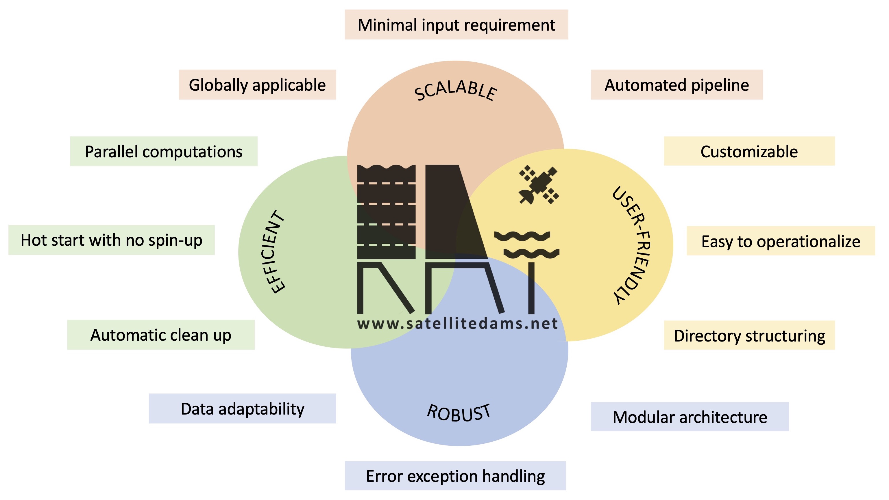
How to cite
Primary Citations:
- Suresh, S., Hossain, F., Minocha, S., Das, P., Khan, S., Lee, H., Andreadis, K., and Oddo, P.: Satellite-based Tracking of Reservoir Operations for Flood Management during the 2018 Extreme Weather Event in Kerala, India, Remote Sensing of Environment, Vol 307, 2024, https://doi.org/10.1016/j.rse.2024.114149
- Minocha, S., Hossain, F., Das, P., Suresh, S., Khan, S., Darkwah, G., Lee, H., Galleli, S., Andreadis, K., and Oddo, P.:Reservoir Assessment Tool Version 3.0: A Scalable and User-Friendly Software Platform to Mobilize the Global Water Management Community, Geoscientific Model Development (In press), 2023, https://doi.org/10.5194/gmd-2023-130 .
- Das, P., S. Suresh, F. Hossain, V. Balakrishnan, Jainet P J, H. Lee, M. Laverde, K. Hosen, C. Meechaiya, P. Towashiraporn. Forecast Informed Reservoir Operations using a Satellite Based Framework for Mountainous and High Precipitation Regions: The case of the 2018 Kerala floods, ASCE Journal of Hydrologic Engineering, 2024
- Das, P., F. Hossain, S. Minocha, S. Suresh, G. Darkwah, K. Andreadis, H. Lee, M. Laverde, P. Oddo ResORR: A Globally Scalable and Satellite Data-driven Algorithm for River Flow Regulation due to Reservoir Operations, Environmental Modeling and Software, vol. 176, 2024, https://doi.org/10.1016/j.envsoft.2024.106026
- Darkwah, G, F. Hossain, G. Holtgrieve, C. Seaton, D. Graves, H. Lee, P. Das, S. Suresh, S. Minocha, S, Khan, Reconstruction of the Hydro-Thermal Behavior of Regulated River Networks of the Columbia River Basin Using Satellite Remote Sensing and Data-driven Techniques, Earth’s Future DOI:10.1029/2024EF004815, 2024.
- Biswas, N., F. Hossain, M. Bonnema, H. Lee, F. Chishtie (2021). Towards a Global Reservoir Assessment Tool for Predicting Hydrologic Impacts and Operating Patterns of Existing and Planned Reservoirs, Environmental Modeling and Software, Vol. 140, 2021, https://doi.org/10.1016/j.envsoft.2021.105043
- Das, P., F. Hossain, S. Khan, N. K. Biswas, H. Lee, Thanapon P., C. Meechaiya, U. Ghimire, and K. Hosen. “Reservoir Assessment Tool 2.0: Stakeholder Driven Improvements to Satellite Remote Sensing Based Reservoir Monitoring.” Environmental Modelling & Software, 157, 105533, 2022, https://doi.org/10.1016/j.envsoft.2022.105533