


RUCA Version 1.11
Travel Distances to Urbanized Areas and Larger Rural Towns
While the RUCA codes are useful in their own right, there is often a need to combine them with travel distance. In order to fill this need, we obtained travel distance information that is available below for all of the nation’s ZIP codes. The travel distances are from the approximate population center of each ZIP code area to the nearest ZIP code area that has a RUCA code of 1.0 or 1.1 (i.e., Census Bureau Urbanized Area core as converted by us from Census tracts – Urbanized Areas have populations of 50,000 or greater), to the nearest ZIP code area that has a RUCA code of 4.0, 4.1, or 4.2 (i.e., Census Bureau Urban Clusters whose populations are from 10,000 through 49,999), and the closer of the two (i.e., the closer of the distance to either the former or the latter).
Travel distance is defined as the distance between the approximate population center of each ZIP code area and the closest of the types of destinations along the fastest paved road route. The travel distances were provided to the WWAMI Rural Health Research Center by the Center for the Evaluative Clinical Sciences at Dartmouth (contact person Dr. David Goodman). Because some ZIP code areas are not connected to others by road (e.g., islands and remote Alaskan towns), they are entered into the data as 100 or more miles. The logic here is that if a ferry or air flight is necessary to reach a destination that effort would be along the lines of a 100-mile car trip. For questions regarding the travel distances, contact Gary Hart (garyhart -at- email dot arizona dot edu). Travel distances are listed in five categories: 1 (less than 30 miles), 2 (30-44 miles), 3 (45-59 miles), 4 (60-89 miles), and 5 (90 or more miles).
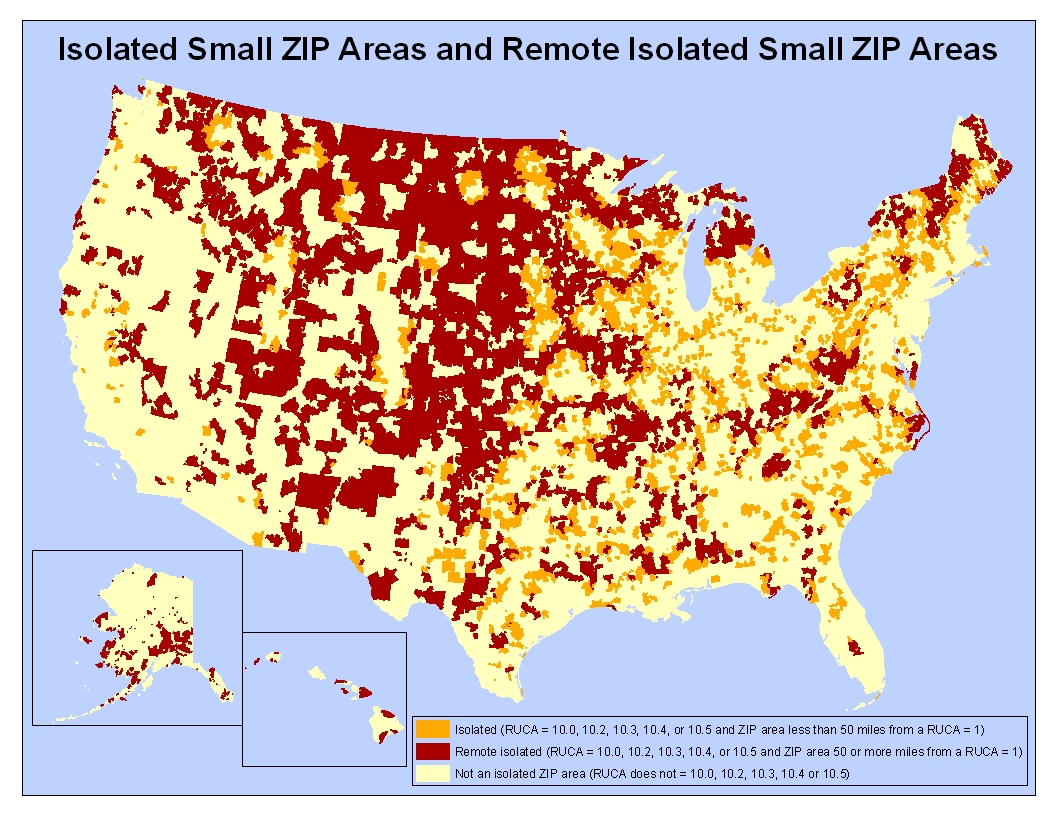
The travel distances that are provided can be used in many different ways in combination with the RUCA codes. For instance, they could be used in combination with the RUCAs to differentiate isolated small ZIP areas (10.0, 10.2, 10.3, 10.4, and 10.5) that are more and less remote – for example, breaking them into two categories based on whether they are 50 miles or more and less than 50 miles travel distance from an urbanized area - where the RUCA code equals one (see map). A problem that has occassionally been noted with the application of RUCAs to some public policies involves RUCA codes 2.0, 2.1, and 2.2. These codes are assigned to ZIP code areas that are not in Census Bureau defined Urbanized Areas, but that are strongly related to them because their primary work commuting flow represents 30% or higher of the daily commuting workers. While these 2s are usually very close to the Urbanized Areas their residents commute to, there are some cases where they are more distant (e.g., a town 50 miles away connected by a high speed road where there is little development between the town and the Urbanized Areas, and the town has a low population). The distance infromation could also be employed in policies so as to include these more distant 2s in rural program eligibility criteria. For example, a policy might exclude all 2s from rural program eligibility except for those whose travel distance is more than 40 miles from the closest RUCA 1 (i.e., closest edge of an Urbanized Area). Likewise, RUCA code 3s could be treated similarly. Click here to download the travel distance file. Click here for the data dictionary (pdf).
One-way mean and median road travel distances are provided in Table 1, Table 2, and Table 3. Table 1 shows the mean and median travel distance from each non 1 ZIP code area to the nearest 1 by the 30 RUCA codes. Similarly, Table 2 shows the mean and median travel distance for each of the states and the District of Columbia. Table 3 shows the mean and median travel distance for each of the 30 RUCAs for each state. All mean and median distances include the associated 2004 population estimate. Thus, the means and medians are weighted by the populations of the ZIP code areas. Note also that in cases where there are not roads between two ZIPs of interest (e.g., islands and isolated places with no connecting roads) 60 miles have been added to the linear distance between them.