For information about this page, contact Greg Balco
Use of data on this page: A variety of people have contributed unpublished data to this project. Please do not make use of the data provided here for other purposes without contacting the person who provided it. Thanks very much.
Disclaimer: Nothing on this page has been reviewed and it should not be considered authoritative. There's a good chance that I've made errors or omissions.
1. Overall story
The point here was to measure the exposure ages of boulders whose true deglaciation age is (or ought to be) known from correlation to the New England varve chronology. Figure 1 below shows the basic story: varve sections occur throughout the Connecticut River valley in central New England. At sites where a basal varve (i.e., sitting on till or bedrock, or in direct ice-proximal deposits) can be found, we know that deglaciation occurred in or near that varve year. This figure shows all the varve sections from Antevs (1922 and 1928) and Ridge (numerous references) that could be easily located via Antevs' publications and Google Earth.
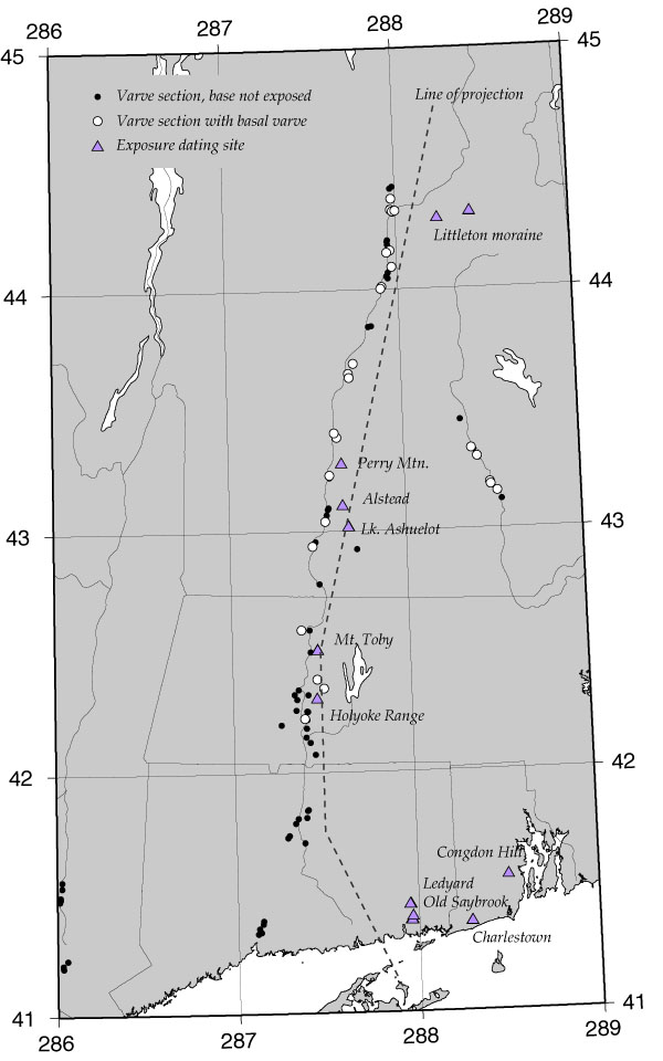
Figure 1.
For Google Earth aficionados, here is the .kml file with locations of varve sections:
Jack, I am sure many of these are in the wrong place. But most of them are pretty close. It is interesting how many of Antevs' sections are now covered by either freeway interchanges or strip malls.
Anyway, we collected boulders for exposure-age measurements in and near the CT River valley. The idea was to be close enough to the valley that the deglaciation age of the sites could reasonably be taken to be the same as that of the valley bottom nearby. This should be reasonably clear from the map. Just so everyone knows what I am talking about, the sites are as follows:
Littleton moraine. Two sites -- the Sleeping Astronomer and the boulder field from Woody's FOP guidebook. Two boulders/site, total 4 samples.
Perry Mountain moraine. There are only two boulders on this moraine; we sampled both of them. One boulder yielded an exposure age of only 5000 yr, whoops. On inspection of the photo, it appears that this boulder is loosely surrounded by soil, whereas the other boulder is the uppermost boulder in a clast-supported and mostly-buried pile of boulders. Thus it seems likely that the boulder with the anomalously young age appeared sometime after deglaciation due to frost heave. Thus, forget about this boulder.
Alstead, NH. One 2x4x6-meter (very large) boulder.
Shoreline of Glacial Lake Ashuelot, Ashuelot River Valley (Jack's fire station site). Two boulders.
Leverett, MA. Three boulders from a boulder field near Mt. Toby.
Holyoke Range, MA. One erratic boulder perched on the summit of the Holoke Range overlooking Hampshire College.
Also shown on the map are some sites where we have exposure ages near the CT and RI coast. The deglaciation age of these sites is limited by the varve chronology -- they must all be older than the oldest varve in the CT Valley chronology as well as 500 yrs of varves at New Haven that are older than that.
2. Varve year deglaciation ages for the exposure-dating sites.
The first thing we have to do is assign deglaciation ages in varve years to the exposure-dating sites. Jack, I have looked at what you sent a while ago, looked at the map, and tried to make sensible judgements here. In order from the north,
Littleton moraine. The Littleton moraine is stratigraphically tied to the varve chronology (Ridge, NEIGC 1996). It's between 7200-7300 NEVyr (in the upper valley chronology -- later I will use slightly different calendar year offsets for the lower and upper series).
Perry Mountain moraine. In the Claremont Gap. Probably towards the end of whatever readvance took place here. 6400-6600 in the upper chronology.
Alstead boulder. See Figure 2 below (which shows the basal ages in varve years for the sections surrounding most of the exposure dating sites). Must be 5800-6000 (lower chronology) according to this map. Jack, when we corresponded about this earlier you suggested 5500-5600. That seems too early, the ice margin would have been down around Brattleboro at that time -- ???
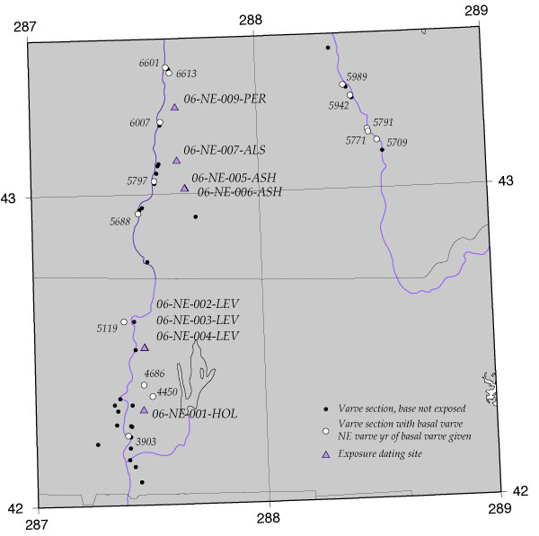
Figure 2
Glacial Lake Ashuelot boulders. As far as I can tell, this site ought to have deglaciated right around Canoe Brook, that is, ca. 5600-5700 (lower). Jack, earlier you said 5300. Again, this seems wrong. Is there some reason you think this site would have deglaciated a lot earlier than Canoe Brook?
Leverett/Mt. Toby boulders. Complicated terrain here, so not so clear what the ice margin was doing. The boulders are actually on the shore of a big spillway that feeds the Montague delta. Regardless, must have deglaciated between Amherst and Turners Falls, so must have been between 4700-5100 (lower).
Holyoke range summit erratic. This is a few hundred meters above the valley bottom, so it could have deglaciated before the lake basin. Say 3900-4100 (lower).
To summarize,
| Site | Deglaciation age (NEvyr) | Approx. +/- | Upper/lower |
| Littleton moraine | 7200 | 100 | upper |
| Perry Mtn. moraine | 6500 | 150 | upper |
| Alstead boulder | 5900 | 100 | lower |
| Lk. Ashuelot | 5700 | 100 | lower |
| Leverett/Mt.Toby | 4900 | 200 | lower |
| Holyoke R. summit erratic | 4000 | 100 | lower |
3. Be-10 and Al-26 measurements:
A spreadsheet with the results in calculator input form is here:
Excel spreadsheet
Details of the AMS data reduction are in a different spreadsheet:
Excel spreadsheet
Some averaging of replicate analyses went into this. Unfortunately, the replicates did not actually agree all that well in a couple of cases. We are looking into this. However, four boulders on the Littleton moraine (which is by far the best site in terms of a direct connection to the varve chronology) agreed with each other very well. Also, Al-26 and Be-10 measurements on these samples were in perfect agreement. So I am very happy with that site.
4. Varve vs. exposure age chronologies for deglaciation:
Figure 3 below shows time-distance relationships for deglaciation inferred from varve and exposure-age chronologies, calculated with the latest production rate calibrations. There are a lot of things on this figure. First, the deglaciation history inferred from the varve chronology reflects two things -- basal varves, which show the position of the ice margin in a given year (black squares and line connecting them), and the lowest non-basal varve at a given site (green triangles) which give minimum ages for deglaciation. Here I've converted varve years to true calendar years using offsets of 20800 for the upper chronology above the Claremont Gap, and 20550 for the lower chronology. This is basically what was described in Balco and Schaefer 2006 and corresponds to a Claremont Gap of 150 yr.
The exposure age chronology is calculated using the online calculators with two different scaling schemes -- non-time-dependent Stone/Lal (St) (black circles and error bars) and time-dependent Lifton et al. 2005 (bluish circles and error bars). These span the range of all the scaling schemes.
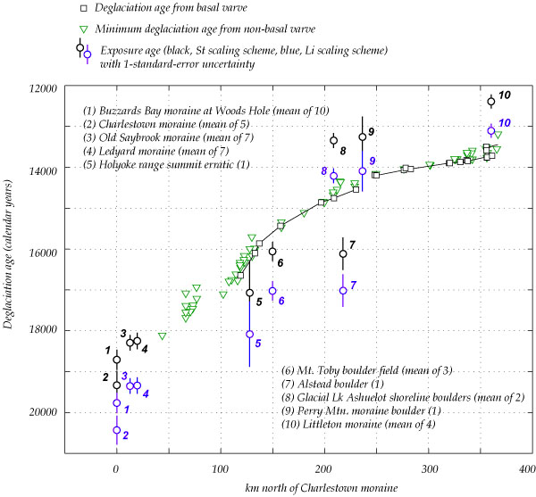
The important things about this figure are as follows.
First, look at the sites to the north -- Littleton (10), Perry Mountain (9), and Ashuelot valley (8). As previously noted, these indicate that normal Stone/Lal scaling scheme (black symbols) severely underestimates deglaciation ages. Other scaling schemes (Lifton, blue symbols) do a better job, but still underestimate the true deglaciation ages. In fact, production rates would need to be lowered by even more than we proposed in the paper last year if we want to match varve and exposure ages for the Littleton moraine. This would have the effect of making events in southern New England even older (and giving Janet another 500 varves or so at the bottom of southern Lake Hitchcock, which she will be happy about). So these sites agree with what we previously argued about the production rate revision needed to bring the two chronologies into line.
Second, the sites at Littleton, Perry Mountain, and Ashuelot all give consistent results. They all underestimate the true deglaciation age of the sites by a similar proportion. So this part of the data set tells a very consistent story. This is good, because these are the best sites, where the site deglaciation is best tied into the varve chronology.
Third, the other sites (Alstead, Leverett, and Holyoke) are not consistent with any of the other data. They all yield exposure ages that are too old relative to the varve chronology. They are a lot too old -- like 1500 yr or 10%. These exposure ages cannot be the correct, because if we RAISED the production rate to bring these sites into line, the Ledyard, Old Saybrook, and Charlestown moraines would become younger than the southernmost Lake Hitchchock varves, which is not allowed. So these results, if taken as production rate calibration sites, lead to impossible contradictions with other exposure-dating results.
This is a bit disturbing, because it's hard to explain why these sites would all yield similarly wacky results. I am inclined to disregard the Alstead boulder -- it is a massively large boulder with displaced striations on the top surface, suggesting transport without too much erosion, so it is at high risk for inherited Be-10. So consider that disregarded. The other sites could suffer from inheritance as well -- one thing that does suggest this is that there is a large spread among three measurements from the Leverett site. The Holyoke erratic should have deglaciated slighly earlier than the lake bottom around it, because it is higher and the ice margin would have been gently sloping to the north, but if we are to use this as an explanation, the top of the Holyoke Range would have been emerging when the ice margin was down around Middletown someplace, which is glaciologically unreasonable.
The summary of all this is that I see no choice but to disregard Holyoke and Mt.Toby as well for purposes of production rate calculations. This isn't very satisfying.
5. Production rate calibration for northeastern North America:
These results clearly reinforce the idea that the current calibration scheme (that is, the global calibration data set in the online calculators) significantly underestimates exposure ages in the northeast US. For purposes of dating events in this area, we should therefore use calibration measurements from the northeast US, rather than the global calibration data set, to determine reference production rates.
So here I actually do this with data from the the Littleton and Perry Mountain moraine boulders and the Lake Ashuelot boulders. I've also calculated reference production rates from some other relevant measurements by Jason Briner -- Be-10 measurements on flood-transported boulders from the Cobblestone Hill spillway near Plattsburgh, and erratics on a radiocarbon-dated glaciomarine delta at Baffin Island. Some remarks about these follow. Overall all of these data together ought to give a pretty good calibration for dating late-glacial events in northeastern North America.
The Cobblestone Hill flood spillway. This spillway (in way northern NY state W of Plattsburgh) is an ice-marginal drainage channel that carried Glacial Lake Iroquois rapidly out to sea. Rayburn et al. give it an age of 13000 +/- 500 in calendar years. I am not totally up on the details of this age control and have to talk to John Rayburn about this. Is this flood recorded in varve sections anywhere? Anyway, Jason has sampled imbricated sandstone boulders and bedrock from the site. Sample data and Be-10 measurements (courtesy of Jason) are here:
The Clyde River delta. Boulders perched on the surface of a glacial marine delta at the E coast of Baffin Island. Full description in Briner et al. 2007 JQS. Age control consists of a minimum limiting radiocarbon age of 7620 +/- 140 C-14 yrs (marine shell) and a maximum limiting radiocarbon age of 7940 +/- 130 C-14 yrs (marine again). Briner et al use 540 yr for the reservoir effect and suggest 7900 cal yr for th eage of delta abandonment. Calibrating these two ages and taking the average gives a little higher, like 8100 cal. Let's say 8100 +/- 250 is a reasonable age assignment. Sample data and Be-10 measurements (courtesy of Jason again) are here:
So I suggest that we ought to use these three calibration sites (New England varve chronology, Cobblestone Hill, and the Clyde Inlet delta) instead of the global calibration data set in calculating exposure ages for late-glacial events in northeastern North America. Here is the result of using these sites to calculate reference production rates for a couple of scaling schemes. These are the best-fitting (in a chi-squared sense) reference production rates to all these data, with each individual sample weighted equally.
| Scaling scheme | Reference Be-10 production rate P10 (atoms/g/yr) |
percent uncertainty | reduced chi-squared | Ratio of this production rate to that used in the v2 online calculator |
| St | 4.42 +/- 0.21 | 4.8 | 0.83 | 0.895 |
| De | 4.63 +/- 0.22 | 4.8 | 0.61 | 0.951 |
| Du | 4.66 +/- 0.22 | 4.8 | 0.62 | 0.953 |
| Li | 5.04 +/- 0.24 | 4.8 | 0.66 | 0.939 |
| Lm | 4.34 +/- 0.21 | 4.8 | 0.65 | 0.899 |
Here are plots of site age vs. reference production rate inferred from each sample that give an idea of how consistent the results are.:
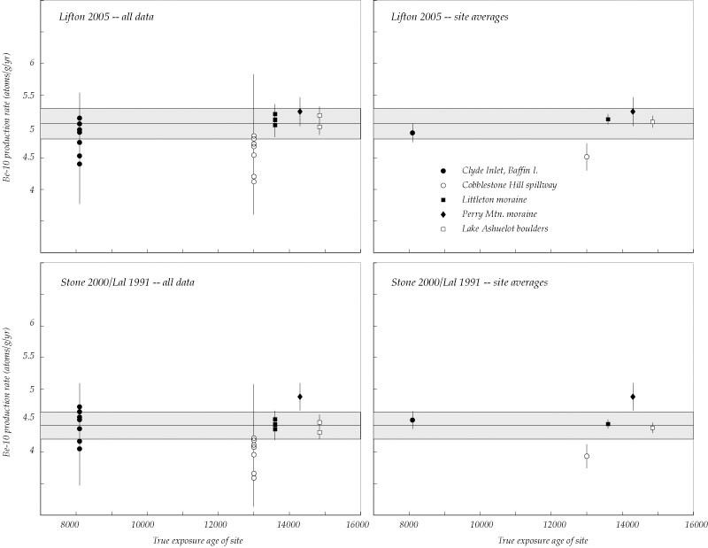
The black lines and gray bands show the best-fit production rates and 1-sigma standard errors. The other time-dependent scaling schemes (Dunai and Desilets et al.) basically give the same results as Lifton 2005.
The interesting things about these results are as follows:
All the data are in good agreement except for the Cobblestone Hill site. If we were to pitch two young outliers from this site it would help a little, but I am going to look into the age control for this site in more detail.
All the scaling schemes fit the data about equally well. This is expected because all the sites are at similar elevation and high latitude. Reduced chi-squared values near 1 indicate that the scatter is commensurate with the measurement uncertainties, that is, the fit is 'statistically acceptable.' The production rate uncertainties derived from this exercise are a bit less than 5%, which is significantly better than that derived from the full global calibration data set (10%). This suggests that with this production rate calibration, events in the NE US can be correlated with independent time scales at about the 5% level.
You need to use a reference production rate at least a few percent lower than the "standard" value inferred from the global calibration data set and used in the online calculators to get the right answer in eastern North America. Thus, ages calculated for eastern N.A. using the online calculators are almost certainly too young. I am working on an improvement to the online calculators that will allow you to choose which calibration sites you want to use, but for now you can implement this by applying an additional correction factor from the table above to the shielding correction when sending data to the online calculator. Note that you have to do this differently for every scaling method, so this is sort of inconvenient.
One possible reason that these sites yield 'low' reference production rates is isostatic rebound, that is, the fact that immediately after deglaciation these sites were lower than their present elevation, so production rates were low for a while. I haven't made any attempt to correct for this effect here. This is probably not that big a deal for calculating ages of deglaciation (because if all production rate calibration sites and unknown sites are ice-marginal deposits, they will have similar elevation-time histories). However, it may provide an explanation for why it is hard to match these data to the global calibration data set.