
"Ten million atoms isn't cool, you know what's cool? Ten thousand atoms" *
Current Research Projects

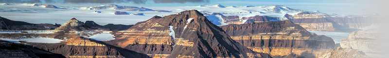
The last ice age in Antarctica
During the last glacial maximum, ice advanced across the continental shelf around Antarctica, and filled the Ross, Weddell and Amery embayments. The ice sheet thickened most around the margins, raising ice levels at the present grounding line by up to 1000 m in places. In the deep interior, lower snowfall resulting from the colder atmosphere and more extensive sea ice cover surrounding the continent restrained thickening, typically to no more than a few tens of meters. Debris carried to the ice-sheet margins left moraines and drift sheets that mark out the former limits of the ice sheet.
We have used cosmic-ray-produced nuclides to determine the age of these deposits in the Prince Charles Mountains and around the East Antarctic coast, in Marie Byrd Land, and alongside several of the large glaciers that cut through the Transantarctic Mountains. At Reedy, Scott and Beardmore Glaciers, and several sites in the Amery Embayment, glacial maximum ice reached its highest level around 18 kyr BP, several thousand years after the culmination of northern hemisphere glaciation. Retreat was more complicated, ending by ca. 10 kyr BP in the Prince Charles Mts and along the East Antarctic Coast, but continuing into the late Holocene (2-3 kyr BP) in Marie Byrd Land and the southern Transantarctic Mts.
More photos and information here.

Drilling to bedrock beneath West Antarctica: A test for past ice-sheet collapse
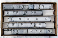
In 2016-17 we recovered a bedrock core from beneath the West Antarctic Ice Sheet in the Pirrit Hills. Our main goal is to analyze the core for cosmic-ray-produced nuclides. Because most cosmic radiation is absorbed by only a few meters of ice cover, the presence or absence of cosmogenic nuclides in this core will provide an unequivocal test of whether the site has been deglaciated by a collapse of the ice sheet in the past 2-3 million years. By measuring a combination of stable and radioactive nuclides we should be able to place constraints on the frequency, duration and timing of interglacial periods warm enough to cause large-scale loss of ice from West Antarctica. Our results will indicate how sensitive the West Antarctic Ice Sheet was to Pleistocene climates warmer than the present-day, which will help to assess its vulnerability to warming in the future.
Our goal was to collect and analyze two cores from different depths beneath the ice sheet, in order to contrast the amount of thinning between different interglacials. However, the drilling technology required for the project is still a work in progress, and we were forced to abandon our first drillhole after losing the drill fluid to a hydrofracture within a few meters of the bed. The second hole, RB-2, was successful, however, and produced 5.5 m of discontinuous ice core above 8 m of bedrock core. We expect to complete measurements on the core and publish our findings in mid-2018.
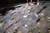
For now, here is a compilation of photos from the 2016-17 field season in the Pirrit Hills, showing the glacial setting of the drill site near Harter Nunatak, drilling operations, and the RB-2 core. You should be able to return using the back button on your browser.
Cosmogenic nuclide calibration
We seem to do a lot of this. As part of the NSF-supported CRONUS project we measured several hundred calibration samples for Be-10, Al-26 and Cl-36. In parallel with these experimental efforts, Dave Argento used the radiation transport code MCNPX to simulate the complicated physics of cosmogenic nuclide production. The result is a detailed model of cosmic ray energy spectra over full ranges of altitude, cut-off rigidity and zenith angle, and coupled with excitation functions to predict production rates of all commonly measured nuclides.
UW CRONUS calibration data here
Cosmic ray simulation results here