

Mapping the Sea Floor Associated with San Juan National Historical Park
By Sandy Wyllie Echeverria, Ph.D.
In response to the U.S. National Parks Service’s interest to understand aquatic processes within the boundaries of San Juan Island National Historical Park (SJINHP), Drs. H.G. Greene and S. Wyllie-Echeverria using the combined techniques of multibeamechosounder (MBES) bathymetry and backscatter data, terrestrial LiDAR aerial photography and underwater videography produced a series of maps illustrating various features of the submerged land associated with SJINHP. The FHL team of Greene and Wyllie-Echeverria with assistance from students and technicians, especially the compilation work of Norman Mailer constructed site-specific habitat and geologic maps that are on display at the SJINHP sites of English and American Camps.
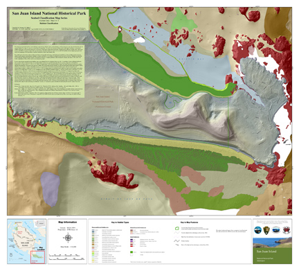
The above image illustrates the various habitat features mapped within the boundaries of American Camp, one of two historical sites included in the San Juan Island National Historical Park. The stippled area within the light green polygon below San Juan Island describes the location of the largest Zostera marina (eelgrass) bed in the San Juan Archipelago. Z. marina beds increase biodiversity and productivity in coastal environments and are protected by federal and state statues.