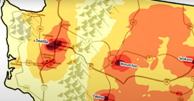
This map indicates the overlap of the areas identified by all respondents as places where they “think people’s English sounds different.” The dark red areas indicate where the most overlap occurs, while the light yellow areas indicate where the least overlap occurs. In the map legend, the overlap is presented as the percentage of the 178 respondents who identified an area. For example, the dark red locations on the map represent the overlap of areas identified by at least 40% of the respondents.
The most prominent feature in this map is the apparent salience of urban areas. That is, the major urban areas of WA were the places that were most frequently identified by respondents on their hand-drawn maps. These areas may be salient to respondents because they view the city as a place that brings many people together therefore resulting in diversity that makes the city different from the surrounding area. This notion is suggested by labels given to these urban areas such as “ethnic groups diverse” or “blended from different cultures”. Urban areas are also where respondents believe there is a great amount of “slang” and also “gangsta” language.
Eastern WA, the area east of the Cascade mountain range, demonstrates a similar pattern of salience of urban areas but also shows more pronounced large regions of overlap. For example, the northeast quadrant of the state seems to be rather salient to all the respondents.
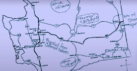
There are lots of reasons why eastern WA might be perceived as different. There is a perceived cultural divide that separates the eastern and western parts of the state along the geographic divide of the Cascade mountain range, often called the “cascade curtain”. The cascade curtain represents a geographic and political divide between ‘westside liberals’ and ‘eastside Republicans’ resulting from the differing population distribution and topography in the two ‘sides’ of the state. The eastern region encompasses counties that have a history of agriculture and they are the top producers of crop and livestock products which may lead eastern WA to be associated with rural, agricultural and ‘cowboy’ culture. This notion is supported by the fact that eastern WA was frequently labeled as “country” or “hick” and, in fact, this notion comprised the largest category of labels given by the respondents.