Reservoir Assessment Tool (RAT 3.0) How to cite
A scalable and easy-to-apply python based software architecture to empower the global water community
The Reservoir Assessment Tool (RAT) uses satellite remote sensing data to monitor water surface area and
water level changes in artificial reservoirs. It uses this information, along with topographical information
(either derived from satellite data, or in-situ topo maps) to estimate the Storage Change (∆S) in the reservoirs.
Additionally, RAT models the Inflow (I) and the Evaporation (E) of each reservoir. Finally, RAT uses the modeled I, and E, and estimated ∆S,
to estimate the Outflow (O) from reservoirs. It was originally developed by Biswas et al. (2021) at SASWE, University of Washington.
The RAT framework developed by Biswas et al. (2021) was a first-of-its-kind open-source reservoir monitoring tool, it is reffered to as the version 1 of RAT,
or RAT 1.0. It currently runs for 3 regions - (1) South and South East Asia, (2) Africa, and (3) South America.The Reservoir Assessment Tool (RAT) 2.0 was
introduced with numerous improvements over the RAT 1.0. Such as weekly satellite observations (every 1-5 days)
using a combination of multiple satellites (Sentinel-2, landsat-8, landsat-9 and Sentinel-1), usage of VIC hydrological model (VIC 5, Hamman et al. (2018))
and MetSim in parallel computation mode, data storage using NetCDF format and explicit representation of Evaporation using the Penman Combination method.
Motivation
RAT was developed as a first-of-its-kind reservoir monitoring tool that could remotely monitor the changing dynamics of reservoirs,
providing the global community with a comprehensive understanding of how they impact natural river flow. One of its original purposes was to serve as a
decision-making tool for forming and evaluating water-sharing agreements between countries in a river basin. Despite the success of RAT 1.0,
the monthly frequency of updating for reservoir state, limited its use. Monthly estimates of reservoir outflow and storage fail to capture the
operating patterns of a reservoir at finer scales, such as hydropeaking, often required for many decision-making needs of the water manager.
RAT 2.0 was therefore developed based on feedback from stakeholders, particularly from member countries of the Mekong River Commission (MRC),
to improve the updating frequency (to weekly) and improve the accuracy of outflow data. This resulted in better decision-making for stakeholder agencies.
As a result, RAT 2.0 was the first major operational uptake by a large inter-governmental river agency such as the MRC. Development of RAT 3.0 is driven
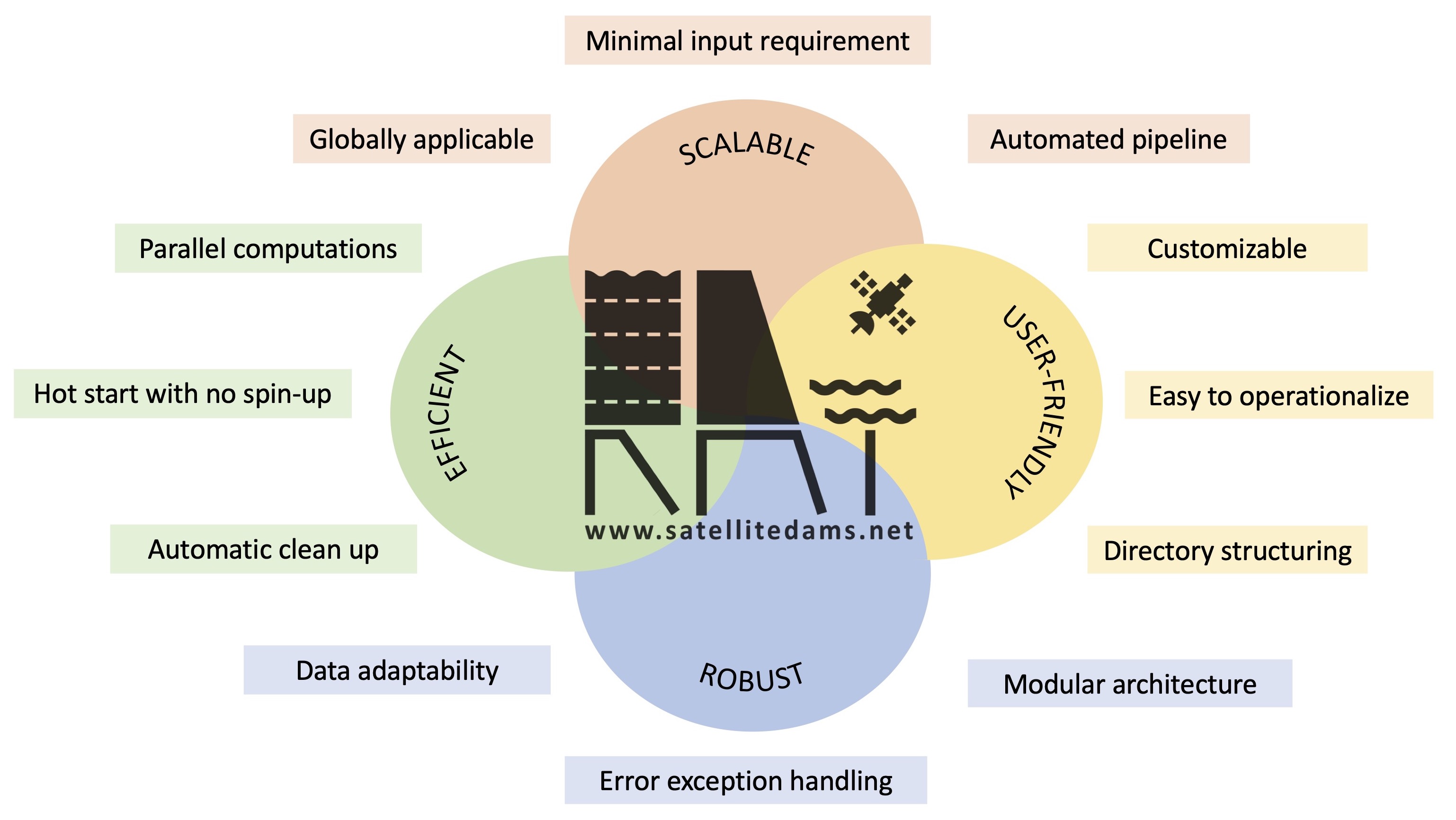
by the need to lower the barrier of entry for first-time users and to improve scalability, robustness and reproducibility. RAT 3.0 is designed to be
easy-to-install and easy-to-operate within an open-source software architecture. Software that is built on these design features can potentially mobilize the
global water community to explore, use and improve RAT in the spirit of open-source development similar to Linux development.
RAT 3.0 can benefit not only governments, hydrologists, researchers, and stakeholders but also the individual user who rely on water resources for their
livelihood, such as farmers, city residents, and fishermen. Access to near real-time information on the reservoir’s dynamic state can empower the
individual user or a community by first quantifying any potential negative impact of floods and droughts, preparing for them, and optimally utilizing
available water resources. The user-friendly installation and operation feature of RAT 3.0 can help farmers make informed decisions on irrigation and
crop planning, assist city residents in water conservation efforts and future usage planning, and aid fishermen in identifying the best fishing locations
while avoiding areas with low water levels. Additionally, a scalable software like RAT 3.0 can be used to plan and optimize hydroelectricity generation.
These are just some of the many examples of what may be possible when a reservoir monitoring tool is made scalable and easy to install and operate.
The below figure captures the major advancements in RAT 3.0. Our motivation for developing the RAT 3.0 software is to accelerate breakthroughs in the
broader field of managed water resources driven by the grassroots needs of global users.
How to cite
Primary Citations:
- Suresh, S., Hossain, F., Minocha, S., Das, P., Khan, S., Lee, H., Andreadis, K., and Oddo, P.: Satellite-based Tracking of Reservoir Operations for Flood Management during the 2018 Extreme Weather Event in Kerala, India, Remote Sensing of Environment, Vol 307, 2024, https://doi.org/10.1016/j.rse.2024.114149
- Minocha, S., Hossain, F., Das, P., Suresh, S., Khan, S., Darkwah, G., Lee, H., Galleli, S., Andreadis, K., and Oddo, P.:Reservoir Assessment Tool Version 3.0: A Scalable and User-Friendly Software Platform to Mobilize the Global Water Management Community, Geoscientific Model Development (In press), 2023, https://doi.org/10.5194/gmd-2023-130 .
- Das, P., S. Suresh, F. Hossain, V. Balakrishnan, Jainet P J, H. Lee, M. Laverde, K. Hosen, C. Meechaiya, P. Towashiraporn. Forecast Informed Reservoir Operations using a Satellite Based Framework for Mountainous and High Precipitation Regions: The case of the 2018 Kerala floods, ASCE Journal of Hydrologic Engineering, vol.30(2), 2024, https://doi.org/10.1061/JHYEFF.HEENG-6276
- Das*, P., F. Hossain, S. Minocha, S. Suresh, G. Darkwah, K. Andreadis, H. Lee, M. Laverde, P. Oddo ResORR: A Globally Scalable and Satellite Data-driven Algorithm for River Flow Regulation due to Reservoir Operations, Environmental Modeling and Software, vol. 176, 2024, https://doi.org/10.1016/j.envsoft.2024.106026
- Darkwah*, G, F. Hossain, G. Holtgrieve, C. Seaton, D. Graves, H. Lee, P. Das, S. Suresh, S. Minocha, S, Khan, P. Oddo, Reconstruction of the Hydro-Thermal Behavior of Regulated River Networks of the Columbia River Basin Using Satellite Remote Sensing and Data-driven Techniques, Earth’s Future (In revision), 2024.
- Biswas, N., F. Hossain, M. Bonnema, H. Lee, F. Chishtie (2021). Towards a Global Reservoir Assessment Tool for Predicting Hydrologic Impacts and Operating Patterns of Existing and Planned Reservoirs, Environmental Modeling and Software, Vol. 140, 2021, https://doi.org/10.1016/j.envsoft.2021.105043
- Das, P., F. Hossain, S. Khan, N. K. Biswas, H. Lee, Thanapon P., C. Meechaiya, U. Ghimire, and K. Hosen. “Reservoir Assessment Tool 2.0: Stakeholder Driven Improvements to Satellite Remote Sensing Based Reservoir Monitoring.” Environmental Modelling & Software, 157, 105533, 2022, https://doi.org/10.1016/j.envsoft.2022.105533