Tsunami Hazard Assessement of the Strait of Juan de Fuca
Work completed in July, 2021
This modeling project by the
UW Tsunami Modeling
Group
will be submitted to the Washington State Emergency Management
Division (EMD) and Washington State Geological Survey (WGS), for use in the
production of maximum inundation and current speed mapping products.
This project was funded by NOAA Award #NA20NWS4670068.
This does not constitute an endorsement by NOAA.
Project report
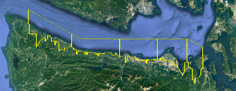
Study regions
The Washington coast of the Strait of Juan de Fuca was modeled from just
east of Neah Bay to just west of Port Townsend. The coast was split into 5
"fgmax regions" where maxima of water depth, flow
speed, and other quantities are captured over the entire simulation.
The extent of the fgmax regions are shown in the Google Earth screenshot
below as
ruled rectangles
that cover all fgmax points and that are used for guiding adaptive mesh
refinement in the GeoClaw code.
From west to east, the five regions are named
- Chito_Sekiu
- Butler_Crescent
- Elwha_PA
- Dungeness_Sequim
- Discovery_PT
The fgmax points within each region are the points that are colored in the
images that can be viewed by downloading each of the kmz files listed below
and opening them in Google Earth.
All off-shore points in a polygonal region along
with all onshore points that are below elevation 35m and accessible from the
coast were selected as fgmax points.
Gauges
Code and data
Results
Notes:
- CSZ_L1 and CSZ_XL1 simulations were run out to 10 hours, but the maximum values
are generally observed much earlier (see the gauge plots).
- kmz files showing topography and fgmax points include a layer that
highlights DEM points that were identified as land below MHW that is
separated from the coast by higher ground. These regions were inspected and
are primarily wet lands. All such areas have been initialized with water
filling in to the MHW level for the GeoClaw runs, i.e., we have not used the
force_dry capabilities
in GeoClaw to force any regions below MHW to be initially dry.
Chito_Sekiu
Butler_Crescent
Elwha_PA
Dungeness_Sequim
Discovery_PT
(Using modified DEM provided by DNR)