


RUCA Data
Travel Distance and Time, Remote, Isolated, and Frontier
From the policy perspective and for many research purposes, it is not only important to define rural but to also create definitions and tools that allow rural to be subdivided along logical and systematically defined criteria. While the RUCA codes do create categories based on the size of city/town and functional relationships as measured by work commuting flows, they do not measure actual travel time and distance. Thus, the RUCA codes measure what can be called functional isolation but not what we might call objective remoteness. In the rural health policy arena, this remoteness concept is almost universally recognized with the word “frontier.” Frontier is thought of as that subset of rural that has different health care delivery systems and other needs because frontier areas are remote from large cities and towns (e.g., most of Alaska, Montana, and other states). This rural health care concept can be objectively defined (e.g., six or fewer persons per square mile for whole counties) or subjectively defined. Attempts are made to define it along sociological, anthropological, and other dimensions. The term “frontier” has a long history of being used quite differently by geographers, demographers, sociologists, and others. In this context, it typically applies to the nation's settlement and the cutting edge of that settlement. The term can be interpreted in different ways by different individuals with different backgrounds and should be used carefully and defined when it is used. We prefer that the term “remote” be used. The new travel time and distance data that are provided with the RUCA ZIP Version 2 download files can be used in combination with the RUCA taxonomy to create useful subsets of rural that are remote and isolated, which identifies, to a great extent, most of what is meant when the term “frontier” is used.
Data are now included in the RUCA ZIP Version 2 download files on travel time and distance. The travel times and distances were purchased from the Center for the Evaluative Clinical Sciences at Dartmouth (i.e., Dr. David Goodman). The one-way paved road travel times and distances are calculated from the population centroid of the origin residential ZIP code area to the population centroid of the destination ZIP code area. An algorithm finds linear distance from the origin population centroid to the nearest paved road and likewise for the destination ZIP code area. Two distance/times were calculated for each ZIP code (excluding 1s – core areas of Urbanized Areas): 1) time/distance to the nearest edge of an Urbanized Areas (RUCA codes 1.0 and 1.1); and 2) time/distance to the nearest edge of a large Urban Cluster (with population of 10,000 or greater). Travel is calculated along the fastest paved road routes. When roads do not connect ZIPs (e.g., islands in Hawaii and remote/isolated towns in Alaska), linear distance was provided. On the download files, there are two versions of the time/distance figures for 1s and large 4s: one gives the actual calculated times and distances substituting the linear distance for the road distance and figuring each linear mile as a minute for the travel time variable. The second set of figures adds an additional 60 miles and 60 minutes when linear distance is used (in addition to the distance). This is to make up for the time lost to take planes, ferries, and other types of transportation. These data are provided on the download files so they can be used in combination with the RUCA codes to refine their use to address the user's needs. For instance, one could select all the RUCA code 10.0, 10.2, 10.3, 10.4, 10.5, and 10.6 ZIPs that are 60 minutes travel time from an Urbanized Area and are more than 40 minutes travel time from a large Urban Cluster of 20,000 population and more. There are numerous such combinations that can be used depending on the needs of the user. Other factors such as weather also can influence travel time and distance (e.g., closed mountain passes in the winter).
Remote, isolated, and remote/isolated (i.e., “frontier”) ZIP code areas and their populations can be identified with the ZIP RUCA codes and the travel time and distance information provided in the download files. In the context of this discussion, remote refers to those ZIPs and populations that are long distances and times from larger cities and towns. Isolated refers to those ZIPs and populations that have little functional relationship (as measured by work commuting flows) with larger cities and towns. Clearly, they are not the same. While two places could be relatively geographically close, they may have small or no commuting flows because of bad roads, lack of economic development, and other factors. Likewise, two cities/towns can be relatively distant from one another and have a strong commuting flow because of high economic activity, good straight roads with high speed limits, and other factors.
The RUCAs and travel times and distances can be used together to create needed definitions of remote and isolated ZIPs. Here are some illustrative examples of the use of RUCA codes and the travel time data:
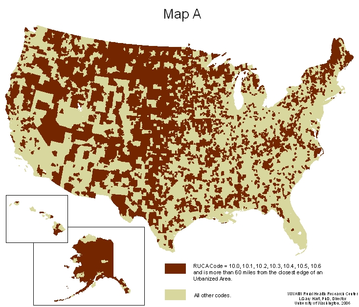
- all ZIPs that have RUCA 10 codes that are more than 60 minutes or greater road travel (one-way) to the closest edge of an Urbanized Area (see Map A).
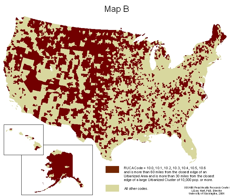
- all ZIPs that have RUCA 10 codes that are more than 60 minutes or greater road travel to the closest edge of an Urbanized Area and are more than 30 minutes or greater road travel to the closest edge of a large Urbanized Cluster of 10,000 population or greater (see Map B) – ZIPs that are both isolated and remote
- all ZIPs that have RUCA 10 codes that are more than 60 minutes or greater road travel to the closest edge of an Urbanized Area and are more than 45 minutes or greater road travel to the closest edge of an Urbanized Cluster of 20,000 population or greater (Map is under construction)
- all ZIPs that have RUCA 10 codes that are more than 60 minutes or greater road travel to the closest edge of an Urbanized Area and are more than 60 minutes or greater road travel to the closest edge of an Urbanized Cluster of 20,000 population or greater (Map is under construction)
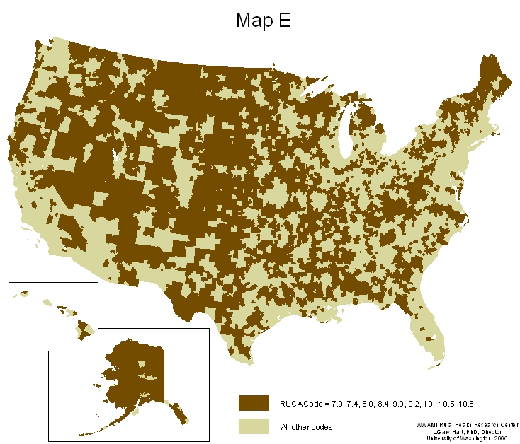
- all ZIPs that have RUCA codes of 7.0, 7.4, 8.0, 8.4, 9.0, 9.2, 10.0, 10.5, and10.6 (all RUCA codes that have primary commuting flow to a small Urban Cluster or to no Census defined cluster and that have less than 30% of their commuting flow to a large Urban Cluster (10,000 population or greater) (see Chart A and Chart B that show state-specific results. See Map E.)
Note how changes in the definitions change the maps and the identified associated populations (See Maps E and F). While we would prefer to put forth a “Remote/Isolated” as a standard definition, we are resisting this suggestion (“E” above is one we like but with the 30% criterion changed to mean 20,000 instead of 30,000 population [map is under construction]). Users should create definitions that best meet their needs. A definition to be used for eligibility for limited funds for a telehealth funding program would be different than one that was aimed at identifying populations for emergency ambulance funding. Other definitions of rural (not remote/isolated) could include all the RUCA code ZIP code areas with the exception of 1s, 2s, 7.1, 8.1, 10.1 (with this even the 3s could be counted as rural – depending on what is meant by the nebulous term “rural”) (these rural areas would include all ZIPs and their populations that are not within the Urbanized Areas [1s] and that have less than 30% of their work commuting going to Urbanized Area).
The federal Office of Rural Health Policy (ORHP) funded a two-year project to create a standardized national rural frontier/remote definition. This project started in fall 2008. The project includes an internal technical advisory group (Mike Ratcliff, Bureau of Census; Andy Isserman, University of Illinois; Eric Larson, University of Washington; and David Plane, University of Arizona), an internal stakeholder group (nine members), and four regional stakeholder meetings (DC, Seattle, Omaha, and Albuquerque). The Department of Agriculture's Economic Research Service (ERS) is a full partner in this project and is also providing significant in-kind funding. The core project team members are Gary Hart (University of North Dakota), John Cromartie (ERS), and Richard Morrill (University of Washington). The ORHP project officer is Steve Hirsch.