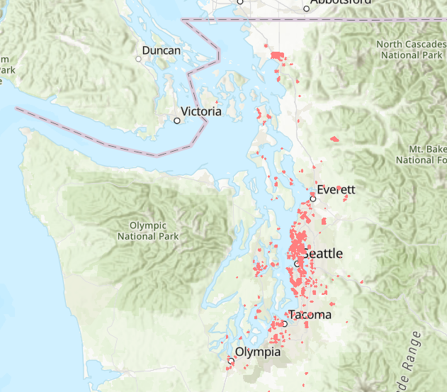
Restricted Properties - Mason County
This interactive map shows the location of more than 1,600 properties that carried racial and sometimes religious restrictions. Zoom to see addresses and restriction language. We are still adding and correcting entries.
See research note.
(Map by Liz Peng)
Reading the map
This preliminary map shows where racial restrictions were added to property records in the decades before 1968. The map currently shows more than 1,600 properties in 37 subdivisions, but our research is ongoing, so check back for updates. Zoom for a closer look or use the search tool. Do not assume that areas without marks were unrestricted. Neighborhoods without covenants often practiced racial exclusion by other means.
The Logic of Restrictions
Areas platted (subdivided) between 1940 and 1960 were most likely to be restricted. This is later than most counties and covered many of the subdivisions created in that period. It was more complicated to restrict older areas which may be why we have not found any in Shelton. However, Shelton enforced racial exclusion by other means. In 1960, there were no (zero) Black households in that city.
Deeds, Plats, Covenants, Petitions
When you click on a property, the pop-up displays address, subdivision (plat), the language of restriction, developer, initial date of restriction, and documentation. This can be either a deed, plat document covering all properties in the subdivision, CCR (separate document filed by developer covering the subdivision), or petition filed by a group of owners covering their listed properties. The last possibility is "Sanborn rule." Courts usually ruled that restrictions could apply even if not mentioned in a deed of sale provided the developer had routinely imposed them in earlier sales. This derived from a 1925 Michigan Supreme Court decision in Sanborn v. McLean.
Credits
Research by Sophie Belz and Amanda Miller. Map by Liz Peng