These maps explore the dimensions of race, politics, and social movements in Washington State. Here are more than a dozen pages grouped in six categories: (1) Washington voting history; (2) Race and segregation history for Seattle, Tacoma, Spokane; (3) Migration History; (4) Labor history locations in Seattle 1900-1940; (5) Radical movements: Socialist Party, Industrial Workers of the World, and Unemployed Citizens League (6) Racial justice movements: the NAACP, Black Panther Party, United Farm Workers (UFW), MEChA and other Chicana/o organizations.
Here are several interactive maps and charts that show the geography of elections featuring detailed information about support for minor and major parties for Presidential, Gubernatorial and Congressional elections. Track the county-by-county support for Socialist Party, Farmer Labor Party, Communist Party, Progressive Party, Peoples Party, as well as for Democratic and Republican parties. Here we map patterns of racial segregation for African Americans, Asians Americans, Native Americans, Latinos, and Whites using census tract data. Explore 70 years of population growth and residential change in this sequence of interactive maps. Select a race category. Click a census tract for detailed information about a neighborhood. Some things to notice: The Central Area served as a ghetto for all peoples of color until the late 1970s. Since then, nonwhite groups have spread in different patterns. And read "Seattle's Race and Segregation Story in Maps 1920-2020," a brief history of the decade by decade changes. Here we map patterns of racial segregation for several Washington counties in sequences of interactive maps. Washington remains today a state where most residents came from somewhere else, another state or another country. With this visualization tool we trace the migration history, showing decade by decade where people have come from. The tool allows us to select by race to track the origins of Asians, Black, Latinos, Natives, and Whites who have settled in Washington. [more] Here are locations of important unions and key events in the history of Seattle labor. Blue pins show events from the General Strike era. Red pins are from the 1930s. Click on a pin to open a description window. Most of the photos show the location today but some have both historial an contemporary images. Many of the events of January and February 1919 took place in the downtown and waterfront sections of Seattle. Here are locations and photographs of strike events, offices and headquarters of the Central Labor Council, Union Record, Metal Trades Council, IWW, Socialist Party, Cooperative Union Market, Japanese Labor Association, and other unions and cooperatives. This interactive map shows the location of key events in the history of Seattle waterfront workers beginning in 1886. Click the markers to see photos and descriptions of each event. These interactive maps locate more than 300 IWW strikes, campaigns, arrests, and vigilante events in Washington State. We also map 60 IWW local unions formed in these years. Events can be filtered by year and by type of event. Hover to see short descriptions. Washington was a stronghold of the Socialist Party with one of the highest per capita memberships in the country before World War I. Here are several interactive maps and charts. One shows votes for SP candidates in every county. Another shows the 19 towns and cities where Socialists won elections. A third maps the newspapers associated with the Socialist Party. We also chart SP membership year by year. In 1913, Tacoma became one of first cities in the country to host a branch of the NAACP. Seattle in 1914, Portand in 1915, and several other communities in the next couple of years. Despite the tiny Black population in the region, NAACP chapters quickly made an impact. In 1914, Tacoma NAACP officers reported that the branch had successfully lobbied the state legislature to stop passage of a law that would have banned mixed race marriages. These maps and data tables display the spread of NAACP chapters along with membership numbers, and branch activity reports. Founded in Oakland in 1967, the Black Panther authorized only 12 additional chapters, one of them the Seattle's chapter, formed in 1969. This map shows BPP offices, facilities, and the location of key events, combining historic images with google street views of the locations today. As part of its 1970 investigation of the Seattle
chapter of the BPP, Congressional investigators for the Committee on Internal
Security Hearings secured photographs of buildings that the Panthers used as
offices or as Breakfast Centers where they served hot meals to children. Click to see photos on the map. They are also reproduced below the map. When ethnic Mexican farm workers led by Cesar Chavez joined with Filipino American workers led by Larry Itliong in 1965 to strike grape growers in Delano, California, the modern farm workers' movement was born. The UFW soon became active in the Pacific Northwest. Boycott committees formed in the cities and on college campuses. Here is an interactive map showing year by year actions across the three state region Chicano students began to organize on college campuses in the late 1960s, forming organizations with various names. In 1969 most of these organizations merged forming El Movimiento Estudiantil Chicano/a de Aztlan (MEChA). MEChA spread in stages and as of 2012 claimed more than 500 chapters. California has long been MEChA's strongest base, but energetic chapters formed early in the Pacific Northwest and have been active ever since. Directed by Professor James Gregory, the Mapping Washington Labor and Civil Rights project has been supported by a 2016-2017 Washington State Labor Research grant from the Harry Bridges Center for Labor Studies, University of Washington. Research Associates: Katie Anastas, Josue Estrada, Rebecca Flores, Arianne Hermida, Cameron Molyneux Technology Advisor: Jason Lee Grills
Voting History
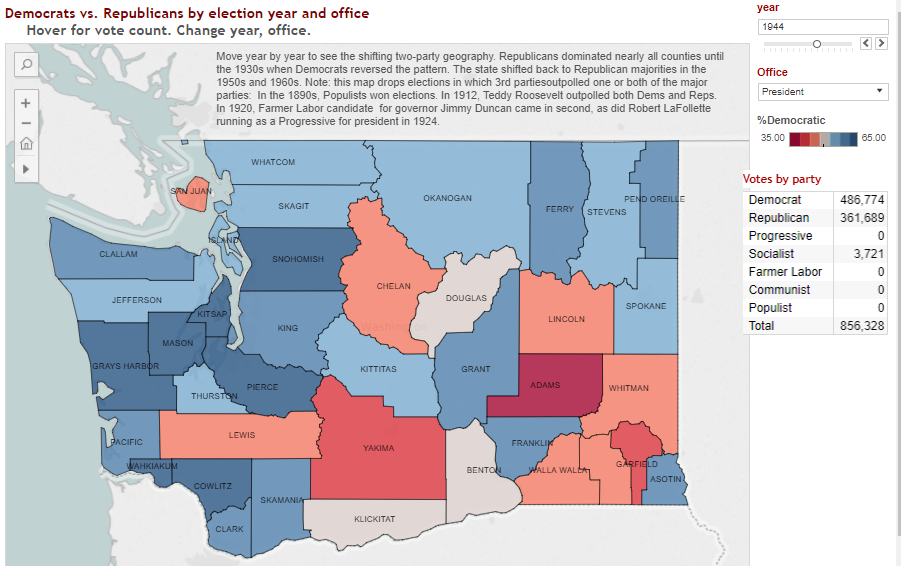 Votes by county for major parties and radical parties 1892-1968
Race and Segregation
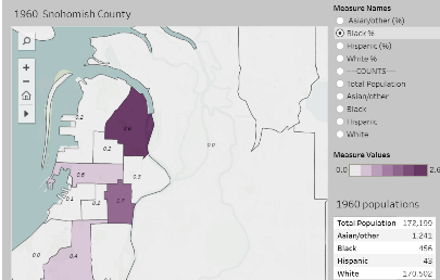
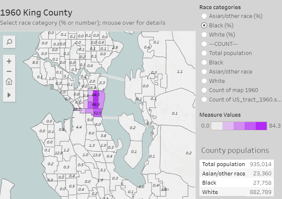 Race and segregation in Seattle/King County 1940-2020
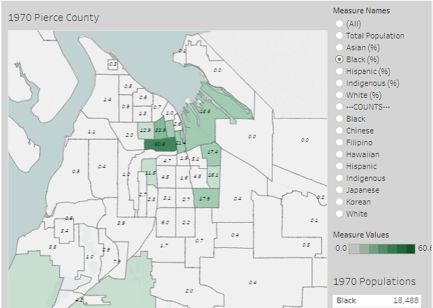
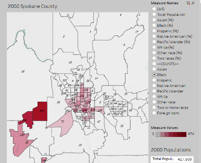
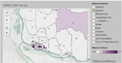
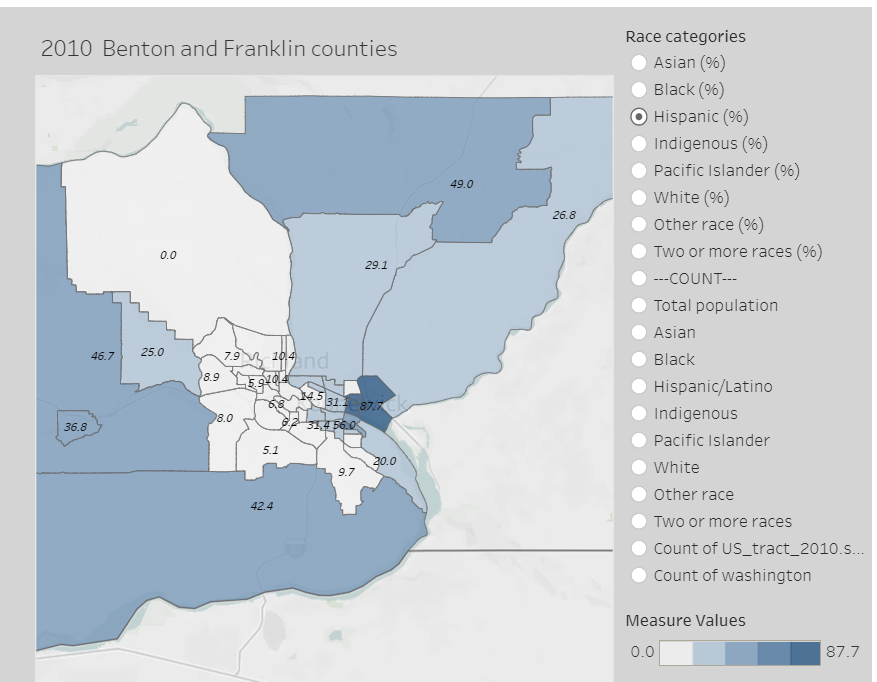
Race and Segregation in Washington Cities and Counties 1940-2020

Migration History
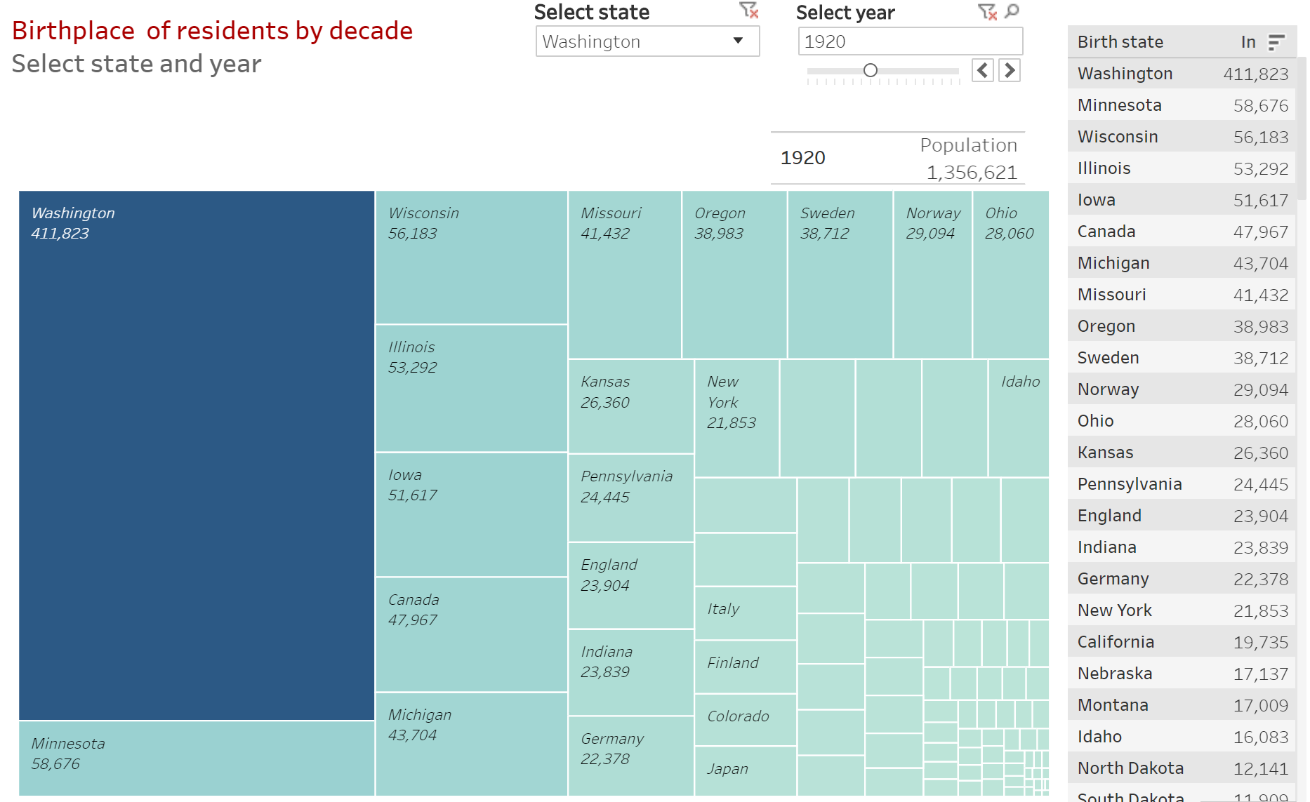 Washington Migration History 1850-2022
Labor History Locations
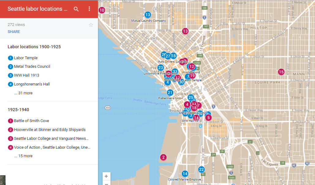 Seattle Labor History Locations 1900-1940
 Seattle's General Strike of 1919
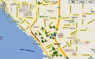
 Seattle's Longshore Workers History 1886 to 2002
Radical Movements: Maps and Data
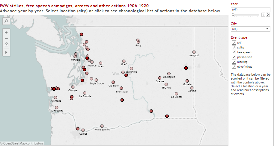 IWW Activities 1906-1920
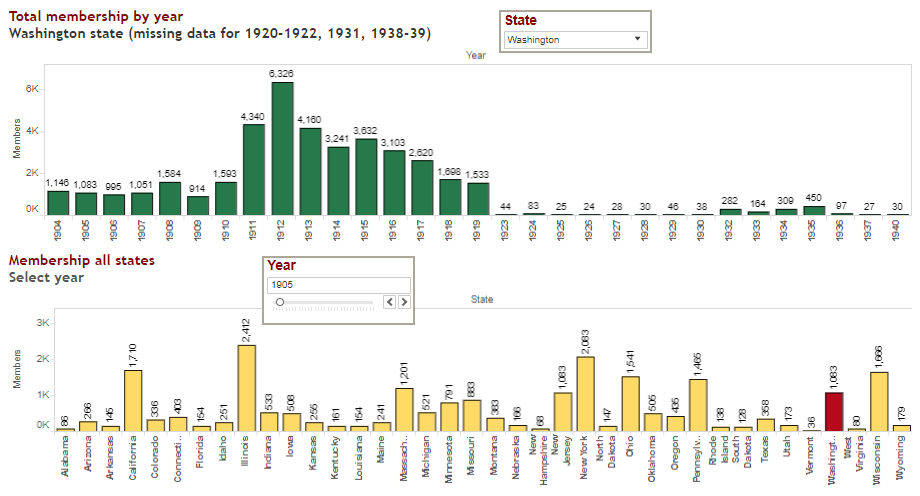 Socialist Party Activity 1900-1940
Racial Justice Movements
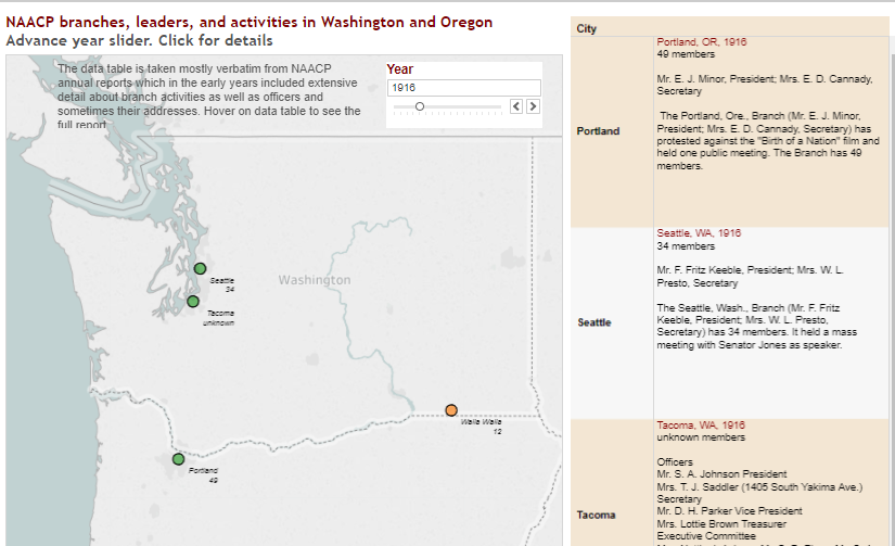 NAACP in Washington and Oregon 1913-1964
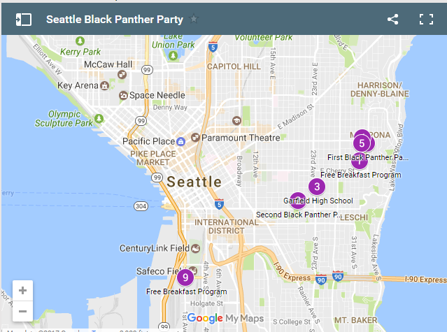
Black Panther Party
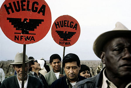
UFW strikes, boycotts, campaigns
1965-1975

MEChA and Chicana/o Student Organizations 1967-2012
About the Project