|
|
|
| The Plio-Pleistocene record of Laurentide Ice Sheet advances |
aka " MR. TE " -- the Minnesota River Till Experiment
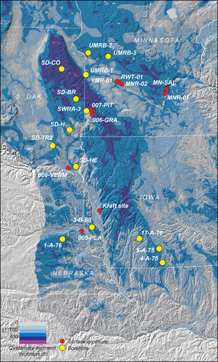
Data repository:This page provides access to all of the analytical data that we collected during this project. This includes in-situ Be-10 and Al-26 measurements on quartz separates, bulk Be-10 measurements on till, soil, and sediment, and density measurements on various sorts of sediment. It's organized by site -- each page linked from the image below shows a stratigraphic log and a graphical summary of the analytical data, followed by various data tables. Links at the bottom of the list at right below provide summary tables of borehole locations and similar data. As this is intended for people who want specific information from our study, it's not fully contextualized -- for an explanation of the significance of and relationship among all the data, please read Greg Balco's Ph.D. dissertation (1.5 mb PDF).
General information about the project is here.
|
|
|
Click on a sample site...
|
Or select from a list...
Boreholes
(Minn. Geol. Survey)
UMRB-1
UMRB-2
UMRB-3
SWRA-3
(S.D. Geol. Survey)
Coddington, SD
Brookings, SD
Hartford, SD
Turkey Ridge, SD
Heeren, SD
(State of Nebraska/UNL/NSF)
3-B-99
1-A-76
17-A-76
5-A-75
4-A-75
Excavations
Kraft site, IA
Surface samples
Surface samples
Summary info
Site locations
Key to drillhole logs
Density measurements
Quartz Be-10/Al-26
Bulk sediment Be-10
|
|
|