Cascadia Rising, Information Sharing and Interoperability
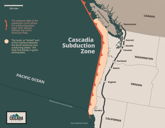
The Cascadia Subduction Zone off the coast of North America spans from northern California to southern British Columbia. This subduction zone can produce earthquakes as large as magnitude 9 and corresponding tsunamis.
Cascadia Rising was a multi-State effort involving agencies across federal, state, local, tribal, international and private sectors in a set of exercises centering around a 9.0 subduction zone earthquake and subsequent 100-foot tsunami. The main exercise, led by the Washington State Emergency Management Division, took place over four days (June 7, 2016 through June 10, 2016). Exercise participants entered into an Incident Command System (ICS) structure to engage in numerous post-disaster missions, many involving complex information sharing scenarios, such as the introduction of Federal assets by US Northern Command (NORTHCOM), the requesting of those assets by county Emergency Operation Centers (EOCs) through the State EOC, and the tracking of those assets by the State EOC and Washington Army National Guard (WANG).
The University of Washington’s Center for Collaborative Systems for Security, Safety, and Regional Resilience (CoSSaR) trained students interested in Homeland Security to be exercise observers. Under a memorandum of understanding (MOU) signed with the WANG and through the cooperation of State and local EOCs, UW researchers and CoSSaR-trained students were placed in strategic locations to observe the flow of mission-based information under degraded, post-disaster conditions. Building on three years of research on Puget Sound regional information sharing, CoSSaR anticipates that analyzing observations from Cascadia Rising will help further map out how the regional information-sharing environment currently works, and where operational improvements could be achieved.
For more information about the Cascadia Rising exercise, visit: https://www.fema.gov/cascadia-rising-2016