I was browsing a couple of older Seattle street maps (1969, and late 1990s) and came across a cluster of streets named for trees and shrubs (Escallonia, Viburnum, Locust, Chestnut, Sumac, Barberry, Heather, Tamarack, Abelia), all tucked in between the east slope of Beacon Hill and near Martin Luther King Jr. Way (or Empire Way on the earlier map). They don’t show up in current online map searches. I am curious about their history.
Before non-Indigenous people settled in the area in the 19th century, this particular area might have been crossed by Duwamish tribe trails that extended from Lake Washington to the Duwamish River along the south edge of Beacon Hill, as well as trails from Pioneer Square to Renton along the Rainier Valley, approximately where Rainier Avenue South is today. The area would have had a wealth of woody vegetation then.
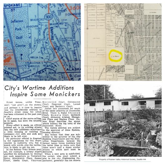
In early 20th century maps of Seattle, I found that the general area you are asking about was at one time owned by Joshua Montgomery Sears, a prominent Bostonian. The area on the 1907 map looks undeveloped, but may have been logged (see Olmsted report below). Sears invested heavily in the King County area, and at one time owned a substantial part of Kirkland. He had a financial interest in the Kirkland Iron Works (as reported in the May 29, 1890 edition of the Seattle Post Intelligencer). I mention Sears because the map snippet you sent shows those streets fanning out around Sears Drive South (which runs from what is now Martin Luther King Jr. Way to S. Columbian Way). In 1930, the city of Seattle purchased the property from the J.M. Sears estate.
This area was part of a 1920s Olmsted plan for what was called the Jefferson Park tract, which included a suggested layout for lot development. A 1903-1905 Olmsted firm report on the Jefferson Park location says that “all of the original forest trees that had any market value have disappeared, and the stumps and logs [… ] are gradually being taken away for firewood […] The southern portion of the park should be made to contrast with the larger open northern part, by having little or no grass, the surface being clothed with low, ground-covering plants. There may be long winding masses of trees and shrubbery […] Some walks may be carried through under the groups of trees, but most of the paths should be carried through the openings between the masses of trees and shrubbery, so as to […] command the distant views of Lake Washington.”
I don’t know if the Olmsted firm ever extended their planting plans beyond Jefferson Park and the surrounding boulevards. There is still a densely forested area now known as Cheasty Greenspace which borders the area where these street names used to be. A photo from 1941 shows newly built houses in an expanse denuded of greenery. At the time, the Seattle Housing Authority had just been formed, headed by Jesse Epstein, a social reformer who championed the creation of affordable public housing. A Russian Jewish immigrant, he grew up in Montana, and began studying at the University of Washington in 1927. Rainier Vista was among his initial Seattle projects, along with Yesler Terrace, Holly Park, High Point, and Sand Point; in every case he lobbied successfully for racially integrated housing.
Work began in 1941 and starting in 1942, the project began serving the housing needs of workers (at Boeing and other industries contributing to the war effort) and later, World War II veterans. The woody plant street names date from the early 1940s. (Some of these plants are classic mid-century stalwarts that are still growing in Seattle neighborhoods.) The names were unusual enough to catch the attention of the Seattle Times in August 17, 1943 [p. 4]. This article discusses their origins: “In the Rainier Vista homes project, for example, a botany expert glorified his enthusiasm by dealing out such monickers as Tamarack Drive, Kinnikinick [sic] Place, Sumac Court, Abelia Court, Viburnum Court and Escalonia [sic] Court. […] The names selected are subject to the approval of Jesse Epstein, housing director.” We don’t know who the botanist was, but naming the streets after trees and shrubs is a gesture toward the idea of a garden community accessible to all, regardless of income, and would have appealed to Epstein. Residents of Rainier Vista and the other housing developments did have gardens, and starting in 1955, the Seattle Housing Authority held an annual Better Yards Roundup competition, sponsored by the Snoqualmie Federation of Garden Clubs.
Your maps show how the streets are cul de sacs, set apart from the more grid-like arrangement of surrounding roads. This design was altered in the 2002 redevelopment, when the previous dwellings were leveled, and construction began. The idea was that streets should connect more directly to the rest of the neighborhood, so as not to isolate the residents from the community. It is a shame to lose the distinctive street names in the process of redevelopment—all except Kinnikinick Place South, east of MLK Jr. Way, which is now an alley with garages facing onto it. Tamarack Drive is gone, but the name lives on in Tamarack Place, an affordable apartment complex on MLK Jr. Way next to the Columbia City light rail station. Interestingly, a 2002 Seattle Times article about the redevelopment mentions a group of black locust trees at the edge of Rainier Vista—a living reminder of Locust Court South. Today, Rainier Vista’s streets encircle a small green space, Central Park, and most blocks are lined with trees in the parking strips. There are also several nearby community gardens that are part of Seattle’s P-Patch program.