
Pedestrians, bicyclists, and other non-motorized road users represent more than 17 percent of all traffic-related fatalities. This project focused on these especially vulnerable road users by developing a way to use information from connected vehicles to identify locations prone to conflicts between motorized and non-motorized users and improve traffic safety on multimodal roadway networks.
Connected vehicle (CV) technology presents great potential to increase the safety of our roadway system by increasing driver situational awareness and reducing or eliminating crashes through vehicle-to-vehicle (V2V), vehicle-to-infrastructure (V2I), and vehicle-to-device (V2X) communication. In a connected environment, road users (drivers, pedestrians, bicyclists) will receive warnings that inform them of potential hazards through visual displays or audible warnings. With increased awareness of potential hazards and other conflicts, roadway users will be able to take preventive actions or evasive maneuvers.
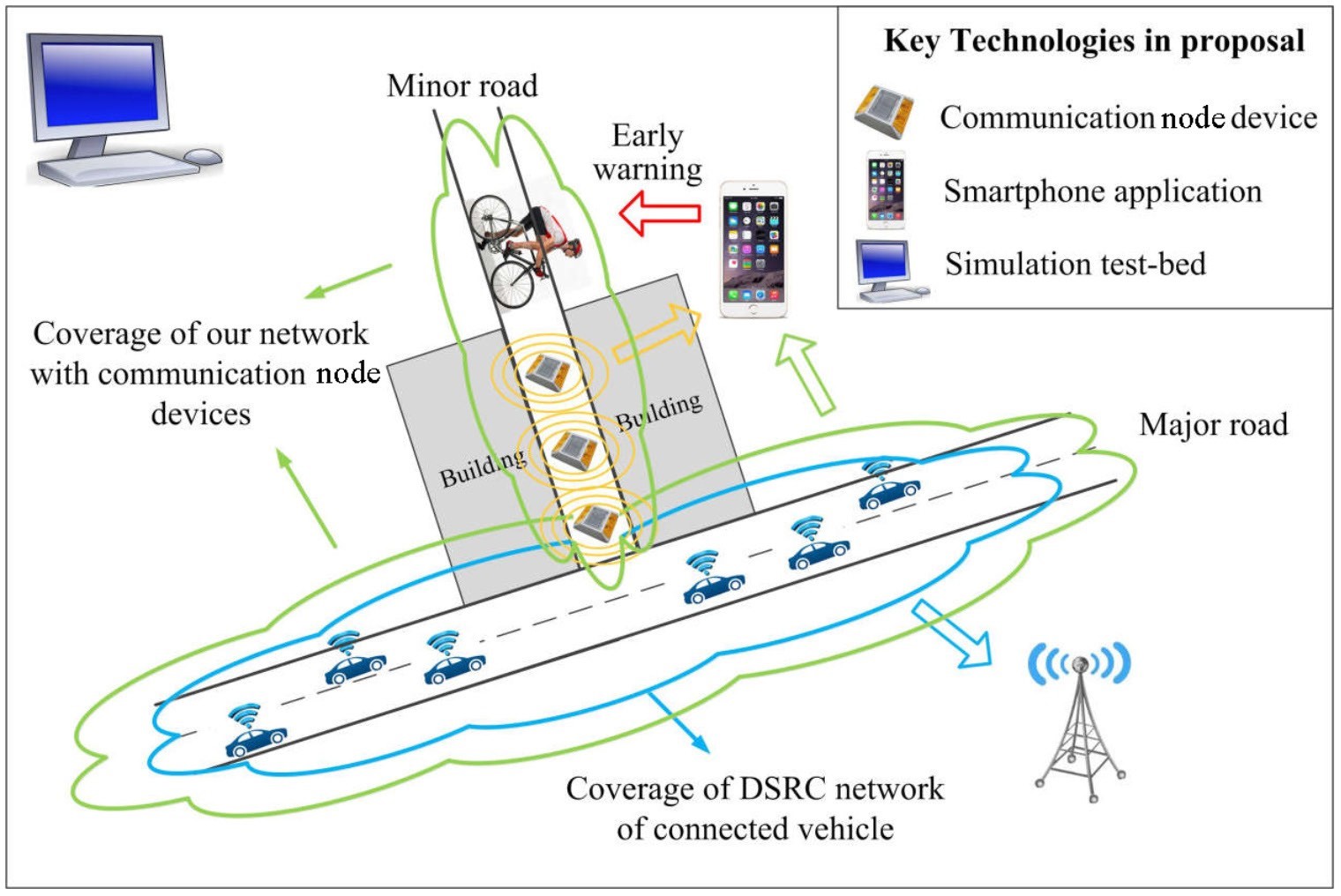
In this project, researchers developed a cost-effective, solar-energy driven, small and lightweight communication device, called the Smart Road Sticker, to enable communication between connected vehicles and other roadway users via Bluetooth and potentially dedicated short range [radio] communications (DSRC). In tandem, they designed a supporting mobile application that allows pedestrians, bicyclists, and drivers of unconnected vehicles to communicate with the Smart Road Sticker. The research team also developed a crash risk prediction algorithm, with application to vehicle/non-motorized user crashes, to identify unsafe conditions and determine appropriate CV-based safety countermeasures. Finally, they created a CV simulation test bed to evaluate the safety benefits of the proposed communication system under various traffic and landscape conditions.
The simulations showed that increasing the volumes of pedestrians and vehicles had a direct relationship with increasing the number of conflicts. However, when the penetration rate of connected devices increased, the number of conflicts decreased. The simulation results also indicated that the highest number of conflicts occurred between through-moving vehicles and pedestrians crossing the road. This is because of the higher volumes of vehicles moving straight. However, increasing the penetration rate of connected devices significantly reduced the number of through-movement conflicts. The number of conflicts for left turns and right turns also decreased. Generally, when the penetration rate of connected devices increased among higher volumes, the number of conflicts decreased.
A final part of the project involved development of a real-world test bed in which to install sensors developed for the project. At the test bed site along State Route 522 north of Seattle, two types of sensors were installed: (1) the Smart Road Sticker and (2) a media access control (MAC) address sensor, developed by the UW Smart Transportation Applications and Research Laboratory (STAR Lab), known as the Mobile Unit for Sensing Traffic, Version 2 (MUST-II). Although data collection and testing at the test bed was not possible because of time and safety constraints, the team is continuing to refine the surrogate safety algorithms and mobile app and hopes to evaluate them at the test bed in the future.
Authors:
Yinhai Wang
John Ash
Yifan Zhuang
Zhibin Li
Ziqiang Zeng
UW Department of Civil and Environmental Engineering
Ali Hajbabaie
Leila Hajibabai
Mehrdad Tajalli
WSU Department of Civil and Environmental Engineering
Sponsors:
WSDOT
PacTrans
WSDOT Project Manager: Doug Brodin