Racial Restrictive Covenants
Neighborhood by neighborhood restrictions across King County
What's In Your Deed? The language of segregation still haunts Seattle and cities and towns throughout Washington State. It lurks in the deeds of more than 37,000 homeowners in King County and at least 35,000 more in other counties. Look deep in the fine print. Many Queen Anne residents have this clause in their deeds: "No person or persons of Asiatic, African or Negro blood, lineage, or extraction shall be permitted to occupy a portion of said property."
Racial restrictions became common in the decades between 1910 and 1960. For most of that time, the restrictions were an enforceable contract and an owner who violated them risked forfeiting the property. Many neighborhoods prohibited the sale or rental of property to Asian Americans and Jews as well as Blacks. In 1968, Congress passed the Fair Housing Act, finally declaring it unlawful to discriminate on the basis of race or ethnicity in the sale or rental of housing. Although decades have passed since 1968, the shadow of these racist restrictions remains, shaping the demography of some neighborhoods, limiting access to homeownership and wealth building for thousands of families who experienced generations of exclusion.
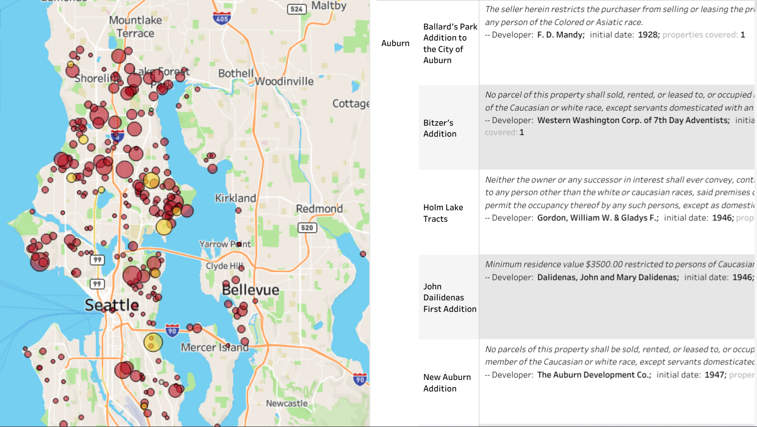
This interactive map shows the exact location of more than 37,000 properties that carried racial and sometimes religious restrictions. Zoom to see addresses and restriction language. We are still adding and correcting entries. See research note.
(Map by Liz Peng)
Reading the map
This preliminary map shows where racial restrictions were added to property records in the decades before 1968. Do not assume that areas without marks were unrestricted. Neighborhoods without covenants often practiced racial exclusion by other means. And we are still adding and correcting entries. See
research note.
The Logic of Restrictions
Areas platted (subdivided) between 1925 and 1950 were most likely to be restricted. Realtors and developers wrote racial exclusions into the initial subdivision documents. All properties in the subdivision were thus legally restricted.
It was more complicated to restrict older areas. Neighborhood associations sometimes organized petition drives and convinced white homeowners to add racial restriction clauses to their properties. However, just because there are some areas on the map that appear to be unrestricted, does not mean that racial exclusion was not enforced by other means.
The Language of Restrictions
Look at the language of restriction in these deeds. Some specify that neighborhoods are reserved for "Whites," while others enumerate the prohibited racial groups. And the wording is curious. In the terminology of the 1920s-1940s "Hebrews" meant Jews; "Ethiopians" meant all African ancestries; "Malays" meant Filipinos; "Mongolians" meant all East Asian ancestries; "Hindus" meant all South Asians.
Most shocking is the "Aryans only" restriction imposed on a subdivision in Clyde Hill. That racial concept, favored by Adolph Hitler, was written into deeds as late as 1948.
- Read More About Seattle's History of Racial Restrictive Covenants
Deeds, Plats, Covenants, Petitions
When you click on a property, the pop-up displays address, subdivision (plat), the language of restriction, developer, initial date of restriction, and documentation. This can be either a deed, a plat document covering all properties in the subdivision, CCR (separate document filed by developer covering the subdivision), or petition filed by a group of owners covering their listed properties. The last possibility is "Sanborn rule." Courts usually ruled that restrictions could apply even if not mentioned in a deed of sale provided the developer had routinely imposed them in earlier sales. This derived from a 1925 Michigan Supreme Court decision in Sanborn v. McLean.
Why do so many neighborhoods appear to be unrestricted?
Restrictive covenants were only one of the tools used to exclude people of color. In older neighborhoods and in the suburban areas that were beginning to develop in the 1950s deed restrictions were too complicated to be widely employed. White supremacists used other means. Real estate agents refused to show property in white neighborhoods and if a family did find a house to rent or buy, they faced neighborhood hostility, harassment, and sometimes violence. Many parts of King County were effectively Sundown Towns.
- Explore Maps of Sundown Towns
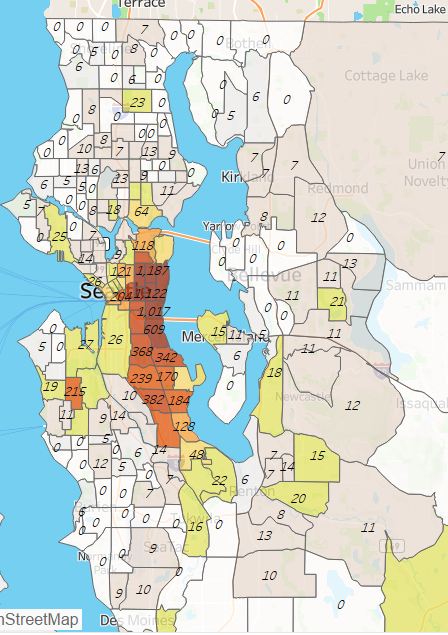
Segregation/exclusion in 1970
The map at right shows where Black families lived and were not allowed to live in 1970, demonstrating that restrictive covenants were not the only means of racial exclusion. The numbers show the count of Black households in each census tract. Eastside neighborhoods rarely had deed restrictions but the map shows that most were off limits to Black and usually Asian families. Census tracts colored white in the map had ZERO Black households. (A typical census tract included about 5,000 residents.) Click to go to an interactive version of the map with full demographic data.
Credits
We are grateful to the King County Archives for providing access to more than 3 million records, many of which we were able to digitize.
Research by Sophia Dowling, Amanda Miller, Jazzlynn Woods, Nicholas Boren, Sam Cutts, Erin Miller, Isabel Smith, Sophie Belz, David Cunningham, Emma Montovani, Ari Bleu Conboy, Bryce Penick, and Annika Tuohey with help from more than 1,900 volunteers who confirmed restrictions on our zooniverse site.