
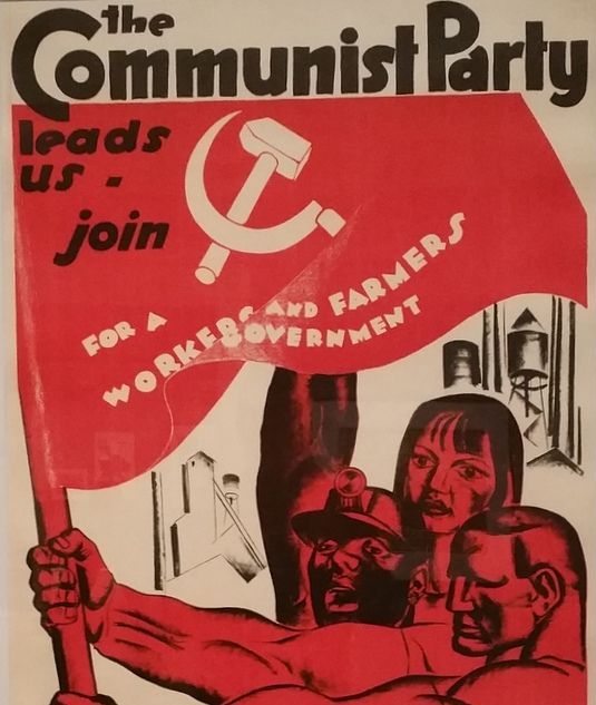
 Hugo Gellert poster for Daily Worker circa 1935 (Merrill C. Berman Collection, New York Historical Society)
Communists split from the Socialist Party in 1919, forming two competing Bolshevik parties that later merged to become the Communist Party USA. A disciplined organization that demanded strenuous commitments and frequently expelled members, the CP was not an open mass organization in the manner of the Socialist Party. Membership levels remained below 20,000 until 1933 and then surged upward in the late 1930s, reaching 66,000 in 1939. Support for the CP was much larger than that, but how large has been an enduring question. Election tallies provide a clue. The CP fielded candidates in presidential and many state and local elections, not expecting to win but expecting loyalists to vote the Party ticket. Communist candidates were able to win about 100,000 votes in several elections during the 1930s and in Senate races in 1940 topped 115,000.
The CP garned support in particular communities, developing a unique geography. These maps and charts detail (1) electoral support, showing the number and percentage of votes for Communist candidates in every county and state from 1922 to 1946; (2) party membership by state or district from 1922-1950; (3) the intense geography of party activism in Chicago 1928-1935; (4) more than 700 unemployed protests organized by the CP in cities across the country 1930-1932; (5) the 1951 "We Charge Genocide" campaign of the party affiliated Civil Rights Congress.
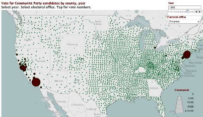
Click to see map and charts Votes for Communist candidates by county and state 1922-1946
This combination of maps and charts suggests the dimensions of support for the Communist Party. The party mounted symbolic but energetic campaigns during each presidential election from 1924 through 1940 and many gubernatorial and congressional races from 1922 to 1944. Move from year to year and filter each map by several variables.
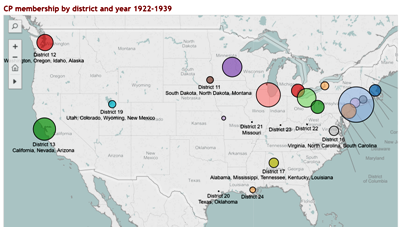
Click to see map and chartsMembership by District 1922-1950
Four maps and charts track Communist Party membership by district during the party's heyday from 1922 to 1950. The CP developed a unique geography, centered in big cities of the North and Pacific West.
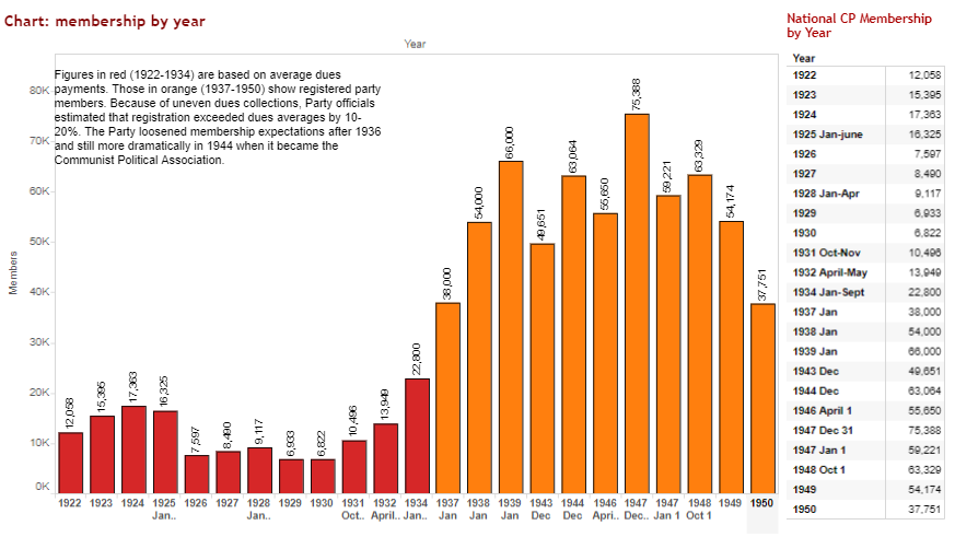
Click to see map and chartsNational Membership 1922-1950
Membership levels remained below 20,000 until 1933 and then surged upward in the late 1930s, reaching 66,000 in 1939, falling off during the Nazi-Soviet detente, then rebuilding after 1941 as the US and the Soviet Union joined in a World War II alliance. Party membership surpassed 75,000 at the start of 1947 before starting its Cold War decline.
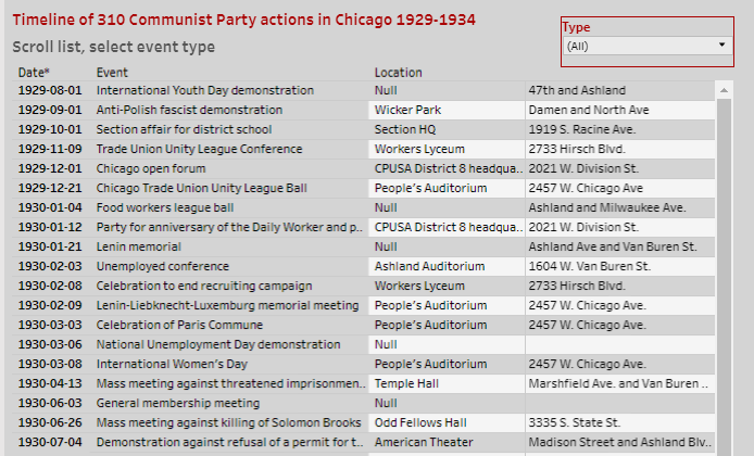
Click to see map and chartsMapping Red Chicago: Grassroots Communist Party Activism 1928-1935
Based on her book Red Chicago, Randi Storch reveals the intense geography of CP activism in a short article accompanied by interactive maps and a timeline/database of more than 300 marches, demonstrations, mass meetings, organizational meetings, picnics, dances, and other actions.
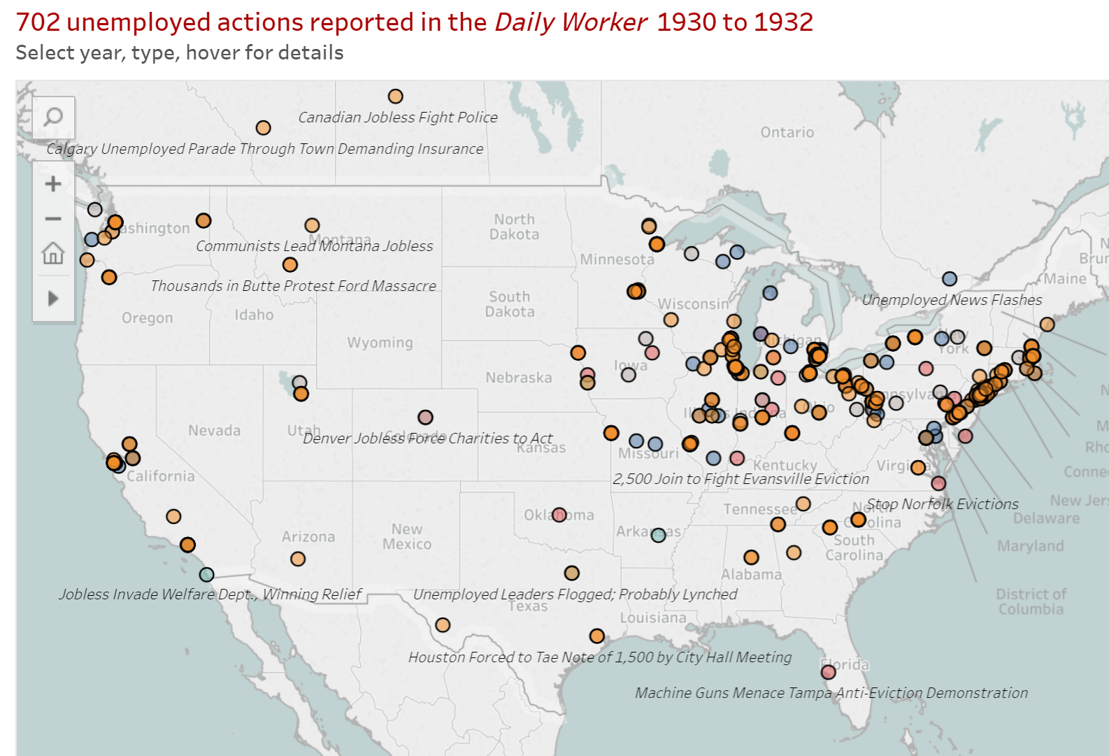
Click to see map and chartsUnemployed Council Protests 1930-1932
Here we map and describe more than 700 protests that took place in the years 1930, 1931, and 1932, nearly all of them involving the Communist Party and the Unemployed Councils. The descriptions are based on articles that appeared in the Daily Worker.

Click to see map and list"We Charge Genocide": The 1951 Black Lives Matter campaign of the Civil Rights Congress
More than sixty years ago, the Civil Rights Congress, affiliated with the Communist Party, engaged in a campaign to hold the United States accountable for genocide against African Americans. We map 152 incidents that the Civil Rights Congress offered as evidence in support of this claim. These killings of unarmed Black men and women by police and by lynch mobs took place between 1945 and 1951. They are displayed on the interactive map and detailed one by one in a descriptive list.