Sources The database, still under construction, was compiled from lists of locals and dues records published at intervals in official publications of the IWW (Industrial Union Bulletin, Industrial Worker, Solidarity) and the following additional sources: 1916 IWW Convention Proceedings, Paul Brissenden, The IWW: A Study of American Syndicalism (1919); Vincent St. John, The IWW: Its History, Structure and Methods (1917); "Names and Addresses of Branch Secretaries of the (I.W.W.) in America" in Military Intelligence Files (IWW) microfilm reel 8; "Minute Books" in same collection reel 6.
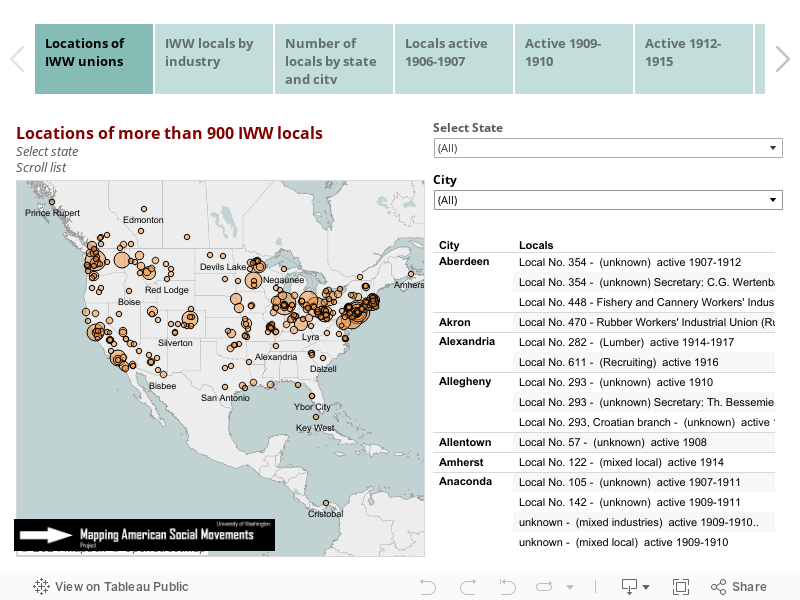
Locations are not exact. Lacking addresses for most locals we have geocoded arbitrary points in each town and city.
Date ranges are not exact. The label "active period" signifies the range for which we have information, but a local may have been founded earlier and often endured longer.
Local numbers, names, industries:The IWW tried to organize along industrial lines, but nearly half of the locals we have found were designated as mixed locals, propaganda leagues, or were identified only by number on the lists we have. Numbers seem to have been assigned haphazardly or in an order that made sense in a local context. For example, there are four Locals No. 3, each in a different city and industry. Despite the model created by Father Thomas Haggerty for the 1905 founding convention, in the first decade the numbering and naming of locals rarely conformed to his famous "Wheel." A few, curiously, carried labels associated with skills rather than industries (i.e. machinists, typographers, blacksmiths). In 1915, the IWW began a reorganization campaign, launching or relaunching broad industrial unions like the Agricultural Workers Organization No. 400 and Lumber Workers Industrial Union No. 500 with branches in many locations. Many but not all of the locals created between 1915 and 1917 followed the new industrial numbering scheme.
Research: Arianne Hermida, James Gregory. Arianne Hermida manages the database.
Maps: James Gregory
Additional IWW maps and charts
|
|
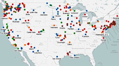
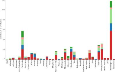
These interactive maps locate more than 1,800 strikes, campaigns, arrests, and persecution events involving the IWW from 1905 to 1920. Events can be filtered by year, state, and type of event. Hover to see short descriptions.
|
|
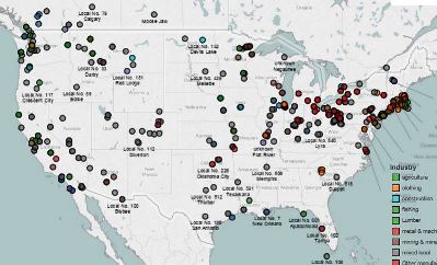
This set of maps locates more than 900 IWW unions in more than 350 cities and towns in 38 states and territories of the United States and 5 Canadian provinces. They are color coded by industry and you may filter by industry and state. |
|
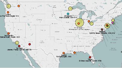
Here are maps showing the 90 newspapers and periodicals affiliated with the IWW. They were published in 19 different languages. These data were compiled by Kenyon Zimmer. |
 Other interactive maps, charts Other interactive maps, charts
More than 450 strikes are mapped. Filter by year. Hover for details on each one. Charts show numbers by state and years.
More than 350 incidents of persecution from 1906 to 1920. |