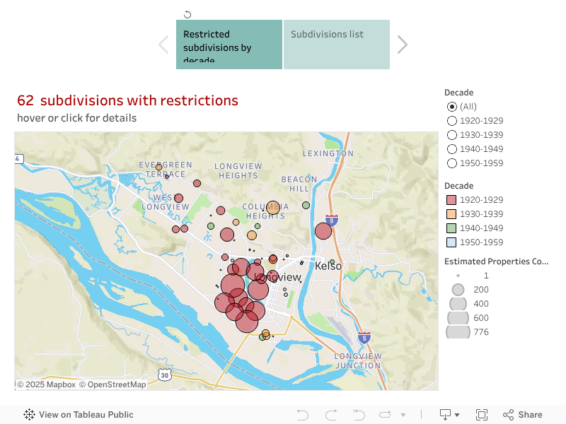
These maps show neighborhoods where racial restrictive covenants were imposed in the decades when they were legal. Most restrictions in Cowlitz County date from 1924 to 1950 and covered a substantial percentage of subdivisions developed in that period. We have documented more than 8,000 restricted properties in 62 subdivisions. Do not assume that areas without circles were unrestricted. Neighborhoods without covenants often practiced racial exclusion by other means. And the practice extended throughout the county.
Scroll below map to find documents. Everything here is preliminary and may change. For a searchable map of individual properties go to our Cowltiz parcels map
| City | Subdivision/plat | Restriction | Properties Covered | Document Type |
| Kelso | Cowlitz Crest | No persons of any race other than the white or caucasian race shall use or occupy any building or any lot, except that this covenant shall not prevent occupancy by domestic servants of a different race domiciled with an owner or tenant. | 26 | Plat |
| Kelso | Homesite Addition | This deed is delivered and accepted upon the express covenant and condition that said real property shall not at any time be sold or leased to, or permitted to be occupied by any person or persons not of what is commonly known as the white of Caucasian Race, and this covenant and condition shall run with the, and shall inure to the benefit of the Grantee, and to the benefit of their successors and assigns. | 380 | Deed |
| Kelso | Park Addition | No persons of any race other than the white or Caucasian race shall use or occupy any building or any lot, except that this covenant shall not prevent occupancy by domestic servants of a different race domiciled with an owner or tenant. | 10 | CCR |
| Longview | Beulah Heights | None of the lots shown on said plats shall be conveyed, leased or given to, and no building erected thereon shall be used, owned or occupied by, any person not of the white race. This prohibition, however, is not intended to include the occupancy of a person not of the white race while employed in or about the premises by the owner or occupant of any land shown on said plat. | 72 | Plat |
| Longview | Cascade Hills | None of the lots shown on said plats shall be conveyed, leased or given to, and no building erected thereon shall be used, owned or occupied by, any person not of the white race. This prohibition, however, is not intended to include the occupancy of a person not of the white race while employed in or about the premises by the owner or occupant of any land shown on said plat. | 117 | Plat |
| Longview | Columbia Heights Gardens | The grantee agrees not to sell to or allow to be occupied by any one not of the white race the above described property. | 255 | Deed |
| Longview | Columbia Valley Gardens No. 1 | None of the lots shown on said plats shall be conveyed, leased or given to, and no building erected thereon shall be used, owned or occupied by, any person not of the white race. This prohibition, however, is not intended to include the occupancy of a person not of the white race while employed in or about the premises by the owner or occupant of any land shown on said plat. | 267 | Plat |
| Longview | Columbia Valley Gardens No. 2 | None of the lots shown on said plats shall be conveyed, leased or given to, and no building erected thereon shall be used, owned or occupied by, any person not of the white race. This prohibition, however, is not intended to include the occupancy of a person not of the white race while employed in or about the premises by the owner or occupant of any land shown on said plat. | 106 | Plat |
| Longview | Columbia Valley Gardens No. 3 | None of the lots shown on said plats shall be conveyed, leased or given to, and no building erected thereon shall be used, owned or occupied by, any person not of the white race. This prohibition, however, is not intended to include the occupancy of a person not of the white race while employed in or about the premises by the owner or occupant of any land shown on said plat. | 78 | Plat |
| Longview | Columbia Valley Gardens No. 4 | 76 | Plat | |
| Longview | Columbia Way Acres | None of the lots shown on said plats shall be conveyed, leased or given to, and no building erected thereon shall be used, owned or occupied by, any person not of the white race. This prohibition, however, is not intended to include the occupancy of a person not of the white race while employed in or about the premises by the owner or occupant of any land shown on said plat. | 78 | Plat |
| Longview | Columbia Way Acres No. 2 | None of the lots shown on said plats shall be conveyed, leased or given to, and no building erected thereon shall be used, owned or occupied by, any person not of the white race. This prohibition, however, is not intended to include the occupancy of a person not of the white race while employed in or about the premises by the owner or occupant of any land shown on said plat. | 77 | Plat |
| Longview | Columbia Way Acres No. 3 | None of the lots shown on said plats shall be conveyed, leased or given to, and no building erected thereon shall be used, owned or occupied by, any person not of the white race. This prohibition, however, is not intended to include the occupancy of a person not of the white race while employed in or about the premises by the owner or occupant of any land shown on said plat. | 62 | Plat |
| Longview | Country Club Addition | None of the lots shown on said plats shall be conveyed, leased or given to, and no building erected thereon shall be used, owned or occupied by, any person not of the white race. This prohibition, however, is not intended to include the occupancy of a person not of the white race while employed in or about the premises by the owner or occupant of any land shown on said plat. | 45 | Plat |
| Longview | Evergreen Terraces | None of the lots shown on said plats shall be conveyed, leased or given to, and no building erected thereon shall be used, owned or occupied by, any person not of the white race. This prohibition, however, is not intended to include the occupancy of a person not of the white race while employed in or about the premises by the owner or occupant of any land shown on said plat. | 54 | Plat |
| Longview | Highland's Addition No. 1 | None of the lots shown on said plats shall be conveyed, leased or given to, and no building erected thereon shall be used, owned or occupied by, any person not of the white race. This prohibition, however, is not intended to include the occupancy of a person not of the white race while employed in or about the premises by the owner or occupant of any land shown on said plat. | 425 | Plat |
| Longview | Highlands Addition No. 2 | None of the lots shown on said plats shall be conveyed, leased or given to, and no building erected thereon shall be used, owned or occupied by, any person not of the white race. This prohibition, however, is not intended to include the occupancy of a person not of the white race while employed in or about the premises by the owner or occupant of any land shown on said plat. | 692 | Plat |
| Longview | Highlands Addition No. 3 | None of the lots shown on said plats shall be conveyed, leased or given to, and no building erected thereon shall be used, owned or occupied by, any person not of the white race. This prohibition, however, is not intended to include the occupancy of a person not of the white race while employed in or about the premises by the owner or occupant of any land shown on said plat. | 540 | Plat |
| Longview | Hillside Acres No. 1 | None of the lots shown on said plats shall be conveyed, leased or given to, and no building erected thereon shall be used, owned or occupied by, any person not of the white race. This prohibition, however, is not intended to include the occupancy of a person not of the white race while employed in or about the premises by the owner or occupant of any land shown on said plat. | 90 | Plat |
| Longview | Hillside Acres No. 2 | None of the lots shown on said plats shall be conveyed, leased or given to, and no building erected thereon shall be used, owned or occupied by, any person not of the white race. This prohibition, however, is not intended to include the occupancy of a person not of the white race while employed in or about the premises by the owner or occupant of any land shown on said plat. | 79 | Plat |
| Longview | Hillside Acres No. 3 | None of the lots shown on said plats shall be conveyed, leased or given to, and no building erected thereon shall be used, owned or occupied by, any person not of the white race. This prohibition, however, is not intended to include the occupancy of a person not of the white race while employed in or about the premises by the owner or occupant of any land shown on said plat. | 23 | Plat |
| Longview | Laurel Heights | None of the lots shown on said plats shall be conveyed, leased or given to, and no building erected thereon shall be used, owned or occupied by, any person not of the white race. This prohibition, however, is not intended to include the occupancy of a person not of the white race while employed in or about the premises by the owner or occupant of any land shown on said plat. | 38 | Plat |
| Longview | Longview Homesteads | RESOLVED, that no property shall be conveyed, leased, or given to, and no building erected thereon shall be used, owned, or occupied by any person not of the white race. | 60 | HOA Minutes |
| Longview | Longview No. 1 | None of the lots shown on said plats shall be conveyed, leased or given to, and no building erected thereon shall be used, owned or occupied by, any person not of the white race. This prohibition, however, is not intended to include the occupancy of a person not of the white race while employed in or about the premises by the owner or occupant of any land shown on said plat. | 426 | Plat |
| Longview | Longview No. 11 | None of the lots shown on said plats shall be conveyed, leased or given to, and no building erected thereon shall be used, owned or occupied by, any person not of the white race. This prohibition, however, is not intended to include the occupancy of a person not of the white race while employed in or about the premises by the owner or occupant of any land shown on said plat. | 187 | Plat |
| Longview | Longview No. 12 | None of the lots shown on said plats shall be conveyed, leased or given to, and no building erected thereon shall be used, owned or occupied by, any person not of the white race. This prohibition, however, is not intended to include the occupancy of a person not of the white race while employed in or about the premises by the owner or occupant of any land shown on said plat. | 4 | Plat |
| Longview | Longview No. 15 | Ownership and occupancy of said property are restricted to persons of the White race. | 12 | Deed |
| Longview | Longview No. 5 | None of the lots shown on said plats shall be conveyed, leased or given to, and no building erected thereon shall be used, owned or occupied by, any person not of the white race. This prohibition, however, is not intended to include the occupancy of a person not of the white race while employed in or about the premises by the owner or occupant of any land shown on said plat. | 138 | Plat |
| Longview | Longview No. 6 | None of the lots shown on said plats shall be conveyed, leased or given to, and no building erected thereon shall be used, owned or occupied by, any person not of the white race. This prohibition, however, is not intended to include the occupancy of a person not of the white race while employed in or about the premises by the owner or occupant of any land shown on said plat. | 66 | Plat |
| Longview | Longview No. 8 | None of the lots shown on said plats shall be conveyed, leased or given to, and no building erected thereon shall be used, owned or occupied by, any person not of the white race. This prohibition, however, is not intended to include the occupancy of a person not of the white race while employed in or about the premises by the owner or occupant of any land shown on said plat. | 585 | Plat |
| Longview | Longview No. 9 | None of the lots shown on said plats shall be conveyed, leased or given to, and no building erected thereon shall be used, owned or occupied by, any person not of the white race. This prohibition, however, is not intended to include the occupancy of a person not of the white race while employed in or about the premises by the owner or occupant of any land shown on said plat. | 97 | Plat |
| Longview | Ocean Beach Highway Addition | It is specifically agreed that Vendor shall have the right and privilege to impose such conditions, restrictions and covenants not, in the opinion of the Vendor, inconsistent with its beneficial use and enjoyment for residential and agricultural purposes, upon the use, occupancy, enjoyment and improvement of said property as Vendor's judgment shall be desirable, including the restriction of ownership or occupancy to persons of the white race, and such conditions, restrictions, and covenants may be included in the deed to said property by Vendor to Purchaser, or in the plat hereinafter referred to, or both, and shall not relieve Purchaser or the obligation to perform the covenants and agreement herein contained. | 61 | Deed |
| Longview | Olympic (unplatted) | Use of said property is restricted to residential and agricultural purposes and ownership to White Race only. | 5 | Deed |
| Longview | Olympic Acres | Ownership and occupancy of said property are restricted to persons of the White Race. | 18 | Deed |
| Longview | Olympic Addition No. 1 | None of the lots shown on said plats shall be conveyed, leased or given to, and no building erected thereon shall be used, owned or occupied by, any person not of the white race. This prohibition, however, is not intended to include the occupancy of a person not of the white race while employed in or about the premises by the owner or occupant of any land shown on said plat. | 776 | Plat |
| Longview | Olympic Addition No. 2 | None of the lots shown on said plats shall be conveyed, leased or given to, and no building erected thereon shall be used, owned or occupied by, any person not of the white race. This prohibition, however, is not intended to include the occupancy of a person not of the white race while employed in or about the premises by the owner or occupant of any land shown on said plat. | 430 | Plat |
| Longview | Olympic Addition No. 3 | None of the lots shown on said plats shall be conveyed, leased or given to, and no building erected thereon shall be used, owned or occupied by, any person not of the white race. This prohibition, however, is not intended to include the occupancy of a person not of the white race while employed in or about the premises by the owner or occupant of any land shown on said plat. | 178 | Plat |
| Longview | Olympic Addition No. 4 | None of the lots shown on said plats shall be conveyed, leased or given to, and no building erected thereon shall be used, owned or occupied by, any person not of the white race. This prohibition, however, is not intended to include the occupancy of a person not of the white race while employed in or about the premises by the owner or occupant of any land shown on said plat. | 59 | Plat |
| Longview | Olympic Gardens | Ownership and occupancy of said property are restricted to persons of the White race. | ** | Deed |
| Longview | St. Helen's Addition No. 1 | None of the lots shown on said plats shall be conveyed, leased or given to, and no building erected thereon shall be used, owned or occupied by, any person not of the white race. This prohibition, however, is not intended to include the occupancy of a person not of the white race while employed in or about the premises by the owner or occupant of any land shown on said plat. | 503 | Plat |
| Longview | St. Helen's Addition No. 2 | None of the lots shown on said plats shall be conveyed, leased or given to, and no building erected thereon shall be used, owned or occupied by, any person not of the white race. This prohibition, however, is not intended to include the occupancy of a person not of the white race while employed in or about the premises by the owner or occupant of any land shown on said plat. | 330 | Plat |
| Longview | St. Helen's Addition No. 3 | None of the lots shown on said plats shall be conveyed, leased or given to, and no building erected thereon shall be used, owned or occupied by, any person not of the white race. This prohibition, however, is not intended to include the occupancy of a person not of the white race while employed in or about the premises by the owner or occupant of any land shown on said plat. | 494 | Plat |