|
|
|
|
|
|
|
|
|
|
|
|
|
|
|
|
|
|
|
|
|
|
|
|
|
|
|
|
 |
|
|
University of Washington
Department of Landscape Architecture
348 Gould Hall
Box 355734
Seattle, WA 98195
206.543.9240
last updated 6.21.06
Download this page as a PDF
|
|
|
|
|
|
|
|
|
|
|
|
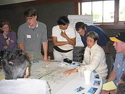
Over 300 civic leaders and community members participated in the Green Futures Charrette on February 3 and 4, 2006. Focusing on 18 different study areas, teams created plans for a comprehensive network of parks, civic spaces, streets, trails, shorelines, and urban forests that will, when implemented, bind neighborhoods to one another, create ecological conduits from the city's ridgelines to its shorelines, boost economic health, and ensure a wealth of green spaces for the coming century.
Teams worked on two time scales, envisioning what their area's open space system might be a full century from now, and creating 20-year plans with near-term priorities. The long-term visions will promote bold choices and catalyze thinking about inevitable disturbances like climate change and earthquake damage, while the 20-year plans will provide roadmaps for imminent decisions about Seattle's open spaces. Delineated by the natural ridges in the city's topography, study areas crossed neighborhood boundaries to create a comprehensive network of open spaces that weaves through and between communities, connecting the city as a whole.(see Study Area Map)
The team products were displayed in a public reception at the charrette's end, and most have been scanned and are available below.
Post-charrette, participants continued to work with advanced landscape architecture and planning students in design studios at the University of Washington, as they digitized and continued to develop ideas to illustrate innovative urban open spaces. The digitized plans will be coalesced into an overall city open space plan. These innovative ideas will be exhibited and presented to the public in May at City Hall, and will be contained in a report to be posted on this website. Concurrently, the Open Space Seattle 2100 coalition is working on advancing adoption and implementation of policies and plans
|
|
|
|
The Charrette Products |
|
|
|
Downtown A
Downtown B
Queen Anne/Magnolia/Interbay
Ballard A
Ballard B
Green Lake
Northwest
Thornton Creek
Sand Point/Magnuson
University District A
University District B
Lake Union A
Lake Union B
Arboretum
Lake Washington
Madison Transect
Rainier Valley A
Rainier Valley B
Rainier Beach
Taylor Creek
Duwamish
Longfellow Creek
West Seattle
|
|
|
|
Project Report: Envisioning Seattle's Green Future
Full Report and Chapters are available as PDFs below. |
|
|
|
Download the Complete Report 176mb
Introduction/Table
of Contents 29mb
Downtown
13mb
Queen Anne/Magnolia/Interbay 21mb
Ballard Ship Canal 6mb
Green Lake
4mb
Northwest
6mb
Thornton Creek 3mb
Sand Point/Magnuson 4mb
University District 1mb
University District - Greenlake 1mb
Lake Union
28mb
Arboretum 7mb
Lake
Washington 17mb
Madison
Transect 2mb
Rainier
Valley 4mb
Rainier
Beach 1mb
Taylor
Creek 2mb
Duwamish 2mb
Longfellow Creek 7mb
West Seattle 1mb
Conclusion 1mb
|
|
|
|
Refined Charrette Plans and Posters
All files are PDFs, average file size is 6 mb
|
|
|
|
Downtown - Team A: 20 and 100 years, Team B: 20 and 100 years
Queen Anne/Magnolia/Interbay - 20 years. 100 years, supporting posters: 1, 2
Ballard - 20 years, 100 years, supporting posters: 1, 2, 3
Green Lake / University District - 20 and 100 years, supporting posters: 1, 2, 3, 4
Crown Hill / Northwest - 20 years, 100 years
Thornton Creek - 20 years, 100 years, supporting poster: 1
Sand Point/Magnuson
University District - 20 and 100 years, supporting poster: 1
Lake Union - 20 years, 100 years, supporting poster: 1
Arboretum - 20 years, 100 years
Lake Washington - 20 and 100 years, supporting posters: 1, 2, 3
Madison Transect - 20 and 100 years, supporting posters: 1, 2, 3, 4, 5, 6, 7, 8
Rainier Valley - 20 and 100 years, supporting posters: 1, 2
Rainier Beach - 20 and 100 years
Taylor Creek - 20 and 100 years, supporting poster: 1
Duwamish - 20 years, 100 years, supporting posters: 1, 2
Longfellow Creek
West Seattle - 20 and 100 years
|
|
|
|
|
|
|
|
Green Infrastructure Plans
|
|
|
|
|
|
|
|
|
Charrette Brief click here to download
Plan Goal
To create a bold integrated Open Space Plan with implementation strategies for Seattle's next hundred years which will enhance the health and well-being of both our cultural and natural environments. This vision of a regenerative green infrastructure will strive to create a healthy, beautiful Seattle while maximizing our economic, social and ecological sustainability.
Process Goals
• To illustrate integrated open space systems and typologies for Seattle's future development
• To forge a striking vision between the public and private sector for Seattle's interconnected network of open spaces over the next century
• To illuminate the connection between open space, density, livability, and sustainability as applied to Seattle's future development
• To create a setting where leading regional designers, planners, politicians, developers, officials, and diverse groups of citizens can exchange ideas and develop new relationships
• To broadly distribute the results of the charrette through a variety of means and venues-to citizens, elected representatives, policy-makers, students and designers-and thereby influence future public policy and legislative initiatives
• To catalyze a long-term advocacy coalition and planning process for Seattle's integrated open space
• To assist in the prioritization of open space efforts in a timeline of targets that includes near-term actions (5, 10, 20 years), with ideas for funding strategies and mechanisms.
• To initiate an outreach plan to spur more in-depth, community-based open space planning.
• To begin the process of identifying conflicts in the city's codes that prevent environmental changes that may contribute to urban livability and ecological health.
Guiding Principles
1. REGIONAL RESPONSIVENESS
Consider Seattle's role as an ecological, economic, and cultural crossroads; its location in one of the world's great estuaries and between two dramatic mountain ranges; its critical position as a threshold to two major watersheds (Cedar and Green/Duwamish); and its relationship to salt and fresh water bodies throughout the city.
2. INTEGRATED AND MULTI-FUNCTIONAL
Integrate a variety of types of open space within a unifying, coherent structure. Incorporate considerations for streets, creeks, parks, habitat, urban forests, trails, drainage, shorelines, views, commercial and civic spaces, back yards and buildings. Consider layering multiple functions and uses within green spaces to create high-functioning, high value open spaces.
3. EQUITY AND ACCESSIBILITY
Within a network of open spaces provide equitable access for all persons to a variety of outdoor and recreational experiences. Distribute appropriate open space types to every neighborhood, in order to address the needs of diverse population groups. Prioritize public access to water.
4. CONNECTIVITY/COHERENCE
Create a wholly connected system that facilitates non-motorized movement, enhances habitat through connectivity, links diverse neighborhoods, and is easy to navigate and understand. Connect these in-city amenities to surrounding communities, trails and public lands.
5. QUALITY, BEAUTY, IDENTITY and ROOTEDNESS
Use Seattle's many natural strengths to create an exemplary, signature open space system. Build on intrinsic qualities, both natural and cultural; reflect, respond to and interpret geographic, ecological, aesthetic and cultural contexts; address emotional and spiritual needs; and inspire a deep connection to place.
6. ECOLOGICAL FUNCTION AND INTEGRITY
Expand the quantity and quality of natural systems in the city: Provide quality habitat for all appropriate species, with a special emphasis on the waters' edge. Design for hydrological health (water temperature, water quality, water regimes, stormwater), and consider appropriate water and resource conservation strategies. Connect to regional ecosystems in order to achieve integrity, resiliency and biodiversity in ecological systems in the face of climate change.
7. HEALTH AND SAFETY
Continue to make the city a safe and healthful place to live. Reduce the risk of natural hazards (slides, flooding, earthquake, soil and water contamination) while reclaiming and treating previously toxic sites. Provide multiple opportunities for exercise, physical activity, and a connection to nature to be integrated into daily lives.
8. FEASIBILITY, FLEXIBILITY AND STEWARDSHIP
While visionary, the plan should be lasting and feasible, with a complementary set of near-term implementation strategies that includes mechanisms for both public and private investment that are achievable in incremental steps and adaptable over time. (e.g. codes, funding sources and incentives). It should be maintainable, inspiring shared stewardship between public agencies, private businesses, and individual citizens to foster pride, purpose and community.
Ground Rules for Charrette Teams
Assumption of Conditions: In 100 years,
1. Seattle's population will reach 642,000* people by 2020 (adding another 75,000 to the current population) and will reach over a million by 2100, all living within Seattle's present urban boundaries. New housing growth will concentrate in dense urban centers, with more children living in urban environments and walking to school. Households be more ethnically diverse and will trend away from the post-war nuclear family structure.
2. The impacts of climate change will continue with Puget Sound waters rising between 1-3 feet; wilder swings of weather, more winter precipitation, less snowpack, and drought conditions by summer's end.
3. Transportation will move to greater efficiencies in response to rising oil prices, with more use of rapid mass transit and new types of transport. The city's road system--now comprising 30% of land cover--will be reconfigured to respond to these new transportation types and will be given new uses. As it reaches the end of its original lifespan, I-5 will be rebuilt or reconsidered.
4. There may have been a major earthquake along the Seattle Fault**, affecting the more vulnerable areas of the city and providing opportunity to reshape transportation infrastructure.
5. Medical insurance premiums will be tiered, based on whether people maintain a healthy lifestyle, e.g., exercise regularly, eat healthy diets, etc.
6. Seattle will be a net zero contributor of greenhouse gases, with standard use of alternative, environmentally benign energy sources. Brownfields will be redeveloped or remediated.
7. As the price of oil increases, food grown outside the region will be more expensive than that produced locally.
8. The economy will continue to shift away from manufacturing and toward international commerce and software/high-tech/biomedical industries.
9. Healthy water and air will continue to be commodified and exchanged between cities and even countries. "Natural capital" will be valued.
10. Waste streams will be recaptured and treated as resources.
* per Seattle Comprehensive Plan, 2005.
**See Scenario for a Magnitude 6.7 Earthquake on The Seattle Fault
Points of Departure
1. Transcend contemporary constraints, innovating new open space types and implementation mechanisms. Be bold!
2. Incorporate considerations for drainage, habitat, urban forests, mobility, streets, affordable urban living, parks, commercial and civic spaces, and private development as well as public investment.
3. Build on existing plans and accomplishments, and Seattle's plans for accommodating growth in urban centers.
4. Base your plans on the realities of Seattle's underlying geography (where does water flow, which slopes are unbuildable, where are views, which areas are most susceptible to earthquake damage, which hills are cyclable, etc.).
5. Measure your developing plans against the "open space and environmental scorecard," integrating best available science, and against the Guiding Goals and Principles.
Team Products
Your package should include:
• A diagram and name of your team's overall City open space concept.
• Concepts, goals and narrative for your Study Area and its integrating, connective context. Include short, medium and long-term goals.
• A plan of your study area at 1" = 400', with labels and descriptions.** Include 20-year and 100-year overlays.
• A plan or diagram showing connections between your study areas and those adjacent.
• Illustrations of key areas in the form of enlarged plans, birdseye views, sections, photographic images, etc.
• Implementation suggestions, including funding paths for acquisition and stewardship. Identify 3-5 near-term Priority Actions for your study area.
|
|
|
|
|
|
|
|