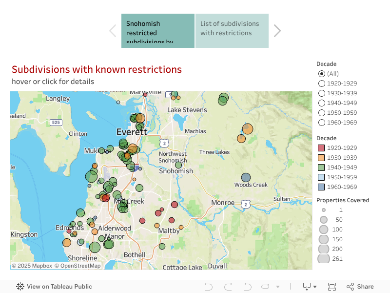
Here we provide documents for neighborhoods where racial restrictive covenants were imposed in the decades when they were legal. Most restrictions in Snohomish County date from 1922 to 1954 (with a few imposed in the 1960s) and covered a large percentage of subdivisions developed in that period. We have documented nearly 7,000 restricted properties in 124 subdivisions. Do not assume that areas without circles were unrestricted; the county mostly practiced racial exclusion by other means. In 1970, the census counted only 1,012 Black residents, 143 of them inmates in Monroe Prison. Asian Americans numbered only 937. The tiny numbers speak to something other than racial segregation. Exclusion was the issue. Exclusionary practices had ensured that the county remained 98.3% white.
The map below is still in progress. For a searchable map of individual properties go to our Snohomish parcels map.
Neighborhood list with attached sample documents
Click the link to see a pdf copy of a restrictive document for each subdivision. There are three types of documents. Some subdivisions were restricted in the original plat; some in covenants (CCR) that applied to the full subdivision. For these we provide full documentation. In other cases the developer/seller included the restrictions in each deed of sale. For these we provide a single deed as a sample.
| City | Subdivision/plat | Restriction | Properties Covered | Document Type |
| Arlington | Highway Home Sites | The land above described shall not be sold, conveyed, rented nor leased in whole or in part to any person not of the white race, nor shall any person not of the white race, nor shall any person not of the white race be permitted to occupy any portion of said land or any building thereon, except as a domestic servant actually employed by a white occupant of said building. | 6 | Deed |
| Brier | Shasta Park Tracts Div. 1 | This property shall not be sold or rented to, or used by any persons not of the Caucasian race. | 40 | Deed |
| Brier | Shasta Park Tracts Div. 2 | This property shall not be sold or rented to, or used by any persons not of the Caucasian race. | 37 | Deed |
| Edmonds | Haggard's Sound View Addition | No person of any race other than the white or Caucasian race shall use or occupy any building or any….. | 12 | CCR |
| Edmonds | Huber's Ridge Acre Addition No. 1 | Only Caucasians shall be permitted | 16 | Plat |
| Edmonds | Olympic View Addition | This property herein described is sold on the express covenant that it shall never be sold to, or occupied by, a negro or person of African descent, nor used for any immoral purpose, or any purpose contrary to any statue or city ordinance. | 4 | Deed |
| Edmonds | Onavu Park Division 1 | No title or interest or right of occupancy of said premises shall ever become vested in any other person other than of the Caucasian race. | 4 | Deed |
| Edmonds | Puget View Tracts | No Nationality other than the Caucasian Race shall be permitted to own any of these Tracts | 6 | Plat |
| Edmonds | Talbot Park | No person of any race other than the White or Caucasian race shall use or occupy any building or any lot in Talbot Park, except that this covenant shall not prevent occupancy by domestic servants of a different race domiciled with an owner or tenant. | 90 | CCR |
| Everett | Airport Acres | The land above described shall not sold, conveyed, rented nor leased in whole or in part to any person not of the white race, nor shall any person not of the white race be permitted to occupy any portion of said lan or any building hereon, except as a domestic servants actually employed by a white occupant of said building. | 74 | Deed |
| Everett | Beverly Hills Div. 4 | No lot shall be sold, conveyed, rented nor leased in whole or in part to any person not of the white race; nor shall any person not of the white race be permitted to occupy any portion of any lot, or any building thereon, excepting as a non-paying guest of or as a domestic servant actually employed by a white occupant or owner of the lot or dwelling. | 17 | CCR |
| Everett | Beverly Viewlands Division No.1 | No race or nationality other than White or Caucasian race shall use or occupy any buildings or building on any lot, except that this covenant shall not prevent use or occupancy by domestic servants employed by an owner or tenant of such lot or the temporary use and occupancy by invited guests of such owner or tenant. | 97 | CCR |
| Everett | Bridgeway | It is understood between said parties that said property shall never be sold, leased, or rented to any negro | 48 | Deed |
| Everett | David's Marine Acres | No lot shall be sold, conveyed, rented, nor leased in whole or in part to any person not of the caucasian race | 31 | Deed |
| Everett | Emery Addition | No lot shall be sold, conveyed, rented nor leased in whole or in part to any person not of the white race; nor shall any person not of the white race be permitted to occupy any portion of nay lot, or any building thereon, excepting as a non-paying guest of or as a domestic servant actually employed by a white occupant or owner of the lot or dwelling. | 20 | CCR |
| Everett | Everett Dells | The Grantee states that neither he nor any member of his immediate family is of any Asiatic, negro, Hawaiian or Malay race, or a person of extraction or descent of any such race | 31 | Deed |
| Everett | Fairview Heights Div. 2 | No lot shall be sold, conveyed, rented nor leased in whole or in part to any person not of the white race; nor shall any person not of the white race be permitted to occupy any portion of any lot, or any building thereon, excepting as a non-paying guest of or as a domestic servant actually employed by a white occupant or owner of the lot or dwelling. | 45 | CCR |
| Everett | Harbor View Addition | No lot shall be sold, conveyed, rented or leased in whole or in part to any person not of the white race; nor shall any person not of the white race be permitted to occupy any portion of any lot, or any building thereon, excepting as a non-paying guest of or as a domestic servant actually employed by a white occupant or owner of the lot or dwelling. | 80 | CCR |
| Everett | Legion Park 1st Addition | No lot shall be sold, conveyed, rented or leased in whole or in part to any person not of the white race; nor shall any person not of the white race be permitted to occupy any portion of any lot, or any building thereon, excepting as non-paying guest of, or as a domestic servant actually employed by a white occupant or owner of the lot or dwelling. | 33 | CCR |
| Everett | Legion Park Addition to Everett | No lot shall be sold, conveyed, rented or leased in whole or in part to any person not of the white race; nor shall any person not of the white race be permitted to occupy any portion of any lot, or any building thereon, excepting as a non-paying guest of, or as a domestic servant actually employed by a white occupant or owner of the lot or dwelling. | 48 | CCR |
| Everett | Legion Park Addition to Everett Div. 2 | No lot shall be sold, conveyed, rented nor leased in whole or in part to any person not of the white or Caucasian race nor shall any person not of the white race or Caucasian race be permitted to occupy any portion of any lot, or of any building thereon, excepting as a non-paying guest or as a domestic servant actually employed by a White or Caucasian occupant or owner of the lot or dwelling. | 143 | CCR |
| Everett | Monson Addition | This lot or any part thereof must never be sold leased or rented to a member of any other than white race | 3 | Deed |
| Everett | Norman Addition | No persons of any race other than White or Caucasian Race shall use or occupy any building or any lot. | 12 | CCR |
| Everett | Paine Field Addition No. 2 | That neither the said premises, or any house, building or improvement hereon erected, shall at any time be occupied by persons of the Ethiopian race, or by Japanese or Chinese, or any other Malay or Asiatic race, or any person of extraction or descent of any such race, save and except as domestic servants in the employ of persons not coming within these restrictions. | 26 | Deed |
| Everett | Paine Field Addition No. 3 | That neither the said premises, or any house, building or improvement hereon erected, shall at any time be occupied by persons of the Ethiopian race, or by Japanese or Chinese, or any other Malay or Asiatic race, or any person of extraction or descent of any such race, save and except as domestic servants in the employ of persons not coming within these restrictions. | 120 | Deed |
| Everett | Paine Field Addition No. 4 | That neither the said premises, or any house, building or improvement hereon erected, shall at any time be occupied by persons of the Ethiopian race, or by Japanese or Chinese, or any other Malay or Asiatic race, or any person of extraction or descent of any such race, save and except as domestic servants in the employ of persons not coming within these restrictions. | 18 | Deed |
| Everett | Peck's Bay View Tracts | It is agreed that neither the grantees their heirs or assigns will sell, lease or otherwise dispose of the above described property to any person or persons except to a member or members of the Caucasian race. | 14 | Deed |
| Everett | Riverdale Addition | No person of any race other than the white or caucasian race shall use or occupy any building or any lot, except that this covenant shall not prevent occupancy by domestic servants or a different race domiciled with an owner or tenant | 6 | CCR |
| Everett | State Addition to Everett No.3 | No race or nationality other than the White or Caucasian race shall use or occupy any building on any lot, except that this covenant shall not prevent occupancy by domestic servants of a different race or nationality employed by an owner or tenant | 53 | CCR |
| Everett | Victory Addition to Everett | No person of any race other than the white or caucasian race shall use or occupy any building or any lot, except that this covenant shall not prevent occupancy by domestic servants or a different race domiciled with an owner or tenant | 95 | CCR |
| Everett | View Ridge Addition to Everett | No race or nationality other than the White or Caucasian race shall use or occupy any building on any lot, except that this covenant shall not prevent occupancy by domestic servants of a different race or nationality employed by an owner or tenant. | 83 | CCR |
| Everett | Westwood | No lot shall be sold, conveyed, rented, nor leased in whole or in part to any person not of the White or Caucasian race nor shall any person not of the White or Caucasian race be permitted to occupy any portion of any lot, or of any building thereon, excepting as a non-paying guest of or as a domestic servant actually employed by a white occupant or owner of the lot or dwelling. | 91 | CCR |
| Lake Stevens | Lake Cassidy Homes | The ownership, use and occupancy of all lots shown on the annexed plat are hereby forever restricted to members of the Caucasian races and for residential purposes only. | 42 | Plat |
| Lynnwood | Alderwood Manor No. 22 | That neither the said premises, or any house, building or improvement hereon erected, shall at any time be occupied by persons of the Ethiopian race, or by Japanese or Chinese, or any other Malay or Asiatic race, or any person of extraction or descent of any such race, save and except as domestic servants in the employ of persons not coming within these restrictions. | 20 | Deed |
| Lynnwood | Hall's Lake Waterfront Addition | No lot shall be conveyed, sold, leased or occupied by any person not of the Caucasian race, except servants. | 16 | Deed |
| Lynnwood | Lake Stickney Tracts | This property shall not be sold or rented to, or used by any persons not of the Caucasian race. | 54 | Deed |
| Lynnwood | Lynnwood | That ownership in this plat shall be forever restricted to people of the Caucasian race or corporations whose officers are of the Caucasian race. | 18 | Plat |
| Lynnwood | Paine Field Addition No. 1 | That neither the said premises, or any house, building or improvement hereon erected, shall at any time be occupied by persons of the Ethiopian race, or by Japanese or Chinese, or any other Malay or Asiatic race, or any person of extraction or descent of any such race, save and except as domestic servants in the employ of persons not coming within these restrictions. | 50 | Deed |
| Maltby | Wellington Heights | This property shall not be sold or rented to, or used by ant persons not of the Caucasian race. | 26 | Deed |
| Martha Lake | Martha Lake Acreage Tracts | This property shall not be sold or rented to, or used by any persons not of the Caucasian race. | 43 | Deed |
| Martha Lake | Martha Lake Acreage Tracts Div. 2 | This property shall not be sold, leased, or rented to any person not of the Caucasian race. | 38 | Deed |
| Martha Lake | Martha Lake East Shore | This property shall not be sold or rented to, or used by, any persons not of the Caucasian race. | 70 | Deed |
| Martha Lake | Martha Lake East Shore Div 2 | Said property shall not be sold, leased or rented to any person not of the Caucasian race. | 42 | Deed |
| Martha Lake | Martha Lake East Shore Div 3 | This property shall not be sold or rented to, or used by, any persons not of the Caucasian race. | 49 | Deed |
| Martha Lake | Martha Lake East Shore Div 4 | This property shall not be sold or rented to, or used by any persons not of the Caucasian race. | Deed | |
| Marysville | Crest View | No lot shall be sold, conveyed, rented or leased in whole or in part to any person not of the white race; nor shall any person not of the white race be permitted to occupy any portion of any lot, or any building thereon, excepting as a non-paying guest of | 34 | CCR |
| Marysville | Marysville Garden Tracts | This property is never to be sold, leased, or rented to any member of other than the white race. | 22 | Deed |
| Mill Creek | Rugg Lake Division | Sale or transfer of any property must be to persons or parties of the Caucasian race. | 29 | CCR |
| Moutlake Terrace | Lake Forest Country Club | That all rights of ownership and residents of the above described property are reserved to those of the Caucasian race. | Deed | |
| Moutlake Terrace | Mount-Lake Terrace | No persons of any race other than White or Caucasian Race shall use or occupy any building or any lot. | 205 | CCR |
| Mukilteo | Chennault Beach | No part or portion of the within described property shall be used or occupied, or be permitted to be used or occupied by any person or persons other than the white or Caucasian Race, except, however, such persons as are employed as servants. | 261 | CCR |
| Mukilteo | Hagen Waterfront Tracts | No property in said plat shall be used or occupied in whole or in part by any persons other than the white or caucasian race | 30 | CCR |
| Mukilteo | Olympus Terrace | No race or nationality other than the White or Caucasian race shall use or occupy any building on any lot, except that this covenant shall not prevent use or occupancy by domestic servants employed by an owner or tenant. | 52 | CCR |
| Mukilteo | Puget Acres | The Buyer states that neither he nor any member of his immediate family is of Asiatic, Negro, Hawaiian, or Malay race or a person of extraction or descent of any such race. | 17 | Deed |
| Mukilteo | Puget Acres No. 2 | The Buyer states that neither he nor any member of his immediate family is of Asiatic, Negro, Hawaiian, or Malay race or a person of extraction or descent of any such race. | 2 | Deed |
| Mukilteo | Ridgemont Park Addition | No race or nationality other than the White or Caucasian race shall use or occupy any building on any lot, except that this covenant shall not prevent use or occupancy by domestic servants employed by an owner or tenant of such lot of the temporary use and occupancy by invited guests of such owner or tenant. | 21 | CCR |
| Picnic Point | Serene Acres No. 3 | It is further agreed that in the event any party to this agreement shall sell, lease or in any manner convey or dispose or his beach lot hereinbefore mentioned and described to any person or persons of the Mongolian or colored race, then and in that event | 4 | Deed |
| Picnic Point | Shelby | Neither the said premises or any house , building or improvement thereon erected, shall at any times be occupied by persons of the Ethiopian race, or by Japanese or Chinese, or any other Malay or Asiatic race | 72 | Deed |
| Picnic Point | Shelby No. 2 | And this deed is made upon the further condition, covenant and agreement, limitation and restriction, that neither the said premises or any house, building or improvement thereon erected, shall at any times be occupied by persons of the Ethiopian race, or by Japanese or Chinese, or any other Malay or Asiatic race, save and except as domestic servants in the employ of persons not coming within this restriction. | 59 | Deed |
| Picnic Point | Shelby No. 3 | Neither the said premises or any house , building or improvement thereon erected, shall at any times be occupied by persons of the Ethiopian race, or by Japanese or Chinese, or any other Malay or Asiatic race | 27 | Deed |
| Picnic Point | Shelby No. 4 | That neither the said premises or any house, building or improvement thereon erected, shall at any times be occupied by persons of the Ethiopian race, or by Japanese or Chinese, or any other Malay or Asiatic race, or any person of extraction or descent of any such race, save and except as domestic servants in the employ of person not coming within this restriction. | 48 | Deed |
| Picnic Point | Shelby No. 5 | And this deed is made upon the further condition, covenant and agreement, limitation and restriction, that neither the said premises or any house, building or improvement thereon erected, shall at any times be occupied by persons of the Ethiopian race, or by Japanese or Chinese, or any other Malay or Asiatic race, save and except as domestic servants in the employ of persons not coming within this restriction. | 9 | Deed |
| Snohomish | Cathcart | The party of the first part can transfer and sell this contract to any desirable person of the Caucasian race only; The party of the second part can transfer and sell this contract to any desirable person of the Caucasian race only | 30 | Deed |
| Snohomish | Lake Bosworth Waterfront Tracts | No lot shall be sold, conveyed, rented, nor leased in whole or in part to any person not of the White or Caucasian race nor shall any person not of the White or Caucasian race be permitted to occupy any portion of any lot, or of any building thereon, excepting as a non-paying Caucasian occupant or owner of the lot or dwelling. | 110 | CCR |
| Snohomish | Lake Roesiger Beach | Said property shall not be sold, leased or rented to any person not of the Caucasian race. | 63 | Deed |
| Snohomish | Lake Roesiger Beach Div. 2 | Said Property shall not be leased or rented to any person not of the caucasian race | 156 | Deed |
| Snohomish | Stockton Heights | No lot shall be sold, conveyed, rented or leased in whole or in part to any person not of the white race; nor shall any person not of the white race be permitted to occupy any portion of any lot, or any building thereon, except as a non-paying guest or owner of the lot or dwelling. | 38 | CCR |
| Woodway | Woodway Park | Neither said premises nor any interest therein shall be, at any time leased, sold, devised or conveyed to, or inherited by or otherwise acquired by, become the property of, be used or occupied by any persons not of the white or Caucasian race, provided however, that persons not of the white or Caucasian race may be kept thereon by white or Caucasian occupant strictly in the capacity of servants of such occupant | 72 | Deed |